
Fichier:Map of the Pacific region (currents).svg

Taille de cet aperçu PNG pour ce fichier SVG : 730 × 543 pixels. Autres résolutions : 320 × 238 pixels | 640 × 476 pixels | 1 024 × 762 pixels | 1 280 × 952 pixels | 2 560 × 1 904 pixels.
Fichier d’origine (Fichier SVG, nominalement de 730 × 543 pixels, taille : 359 kio)
Ce fichier et sa description proviennent de Wikimedia Commons.
.svg?uselang=fr)
Description
| Description |
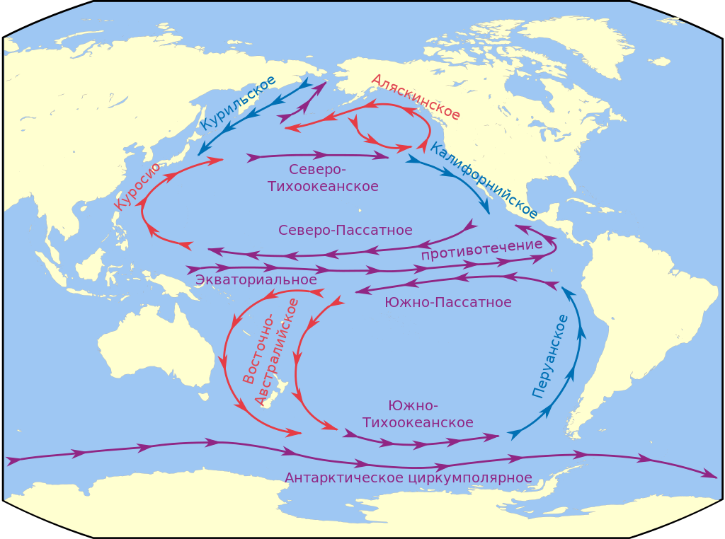
Русский: Течения Тихого океана |
| Date | |
| Source | на основе Map of the Pacific region.svg |
| Auteur |
|
.svg)
|
Ce fichier SVG contient du texte encapsulé pouvant facilement être traduit dans votre langue en utilisant n'importe quel éditeur de fichier SVG ou de texte, ou par l'outil de traduction de fichiers SVG. Pour plus d'informations, voir : A propos de la traduction des fichiers SVG. |
.svg)
| Cette image a été retouchée, ce qui signifie qu'elle a été modifiée par ordinateur et est différente de l'image d'origine. Liste des modifications : +течения. L'image d'origine se trouve ici : Map of the Pacific region.svg:
|
Conditions d’utilisation
Ce fichier est disponible selon les termes de la licence Creative Commons Attribution – Partage dans les Mêmes Conditions 3.0 (non transposée).
- Vous êtes libre :
- de partager – de copier, distribuer et transmettre cette œuvre
- d’adapter – de modifier cette œuvre
- Sous les conditions suivantes :
- paternité – Vous devez donner les informations appropriées concernant l'auteur, fournir un lien vers la licence et indiquer si des modifications ont été faites. Vous pouvez faire cela par tout moyen raisonnable, mais en aucune façon suggérant que l’auteur vous soutient ou approuve l’utilisation que vous en faites.
- partage à l’identique – Si vous modifiez, transformez, ou vous basez sur cette œuvre, vous devez distribuer votre contribution sous la même licence ou une licence compatible avec celle de l’original.
Historique du fichier
Cliquer sur une date et heure pour voir le fichier tel qu'il était à ce moment-là.
| Date et heure | Vignette | Dimensions | Utilisateur | Commentaire | |
|---|---|---|---|---|---|
| actuel | 16 mars 2022 à 12:19 | | 730 × 543 (359 kio) | Ата | File uploaded using svgtranslate tool (https://svgtranslate.toolforge.org/). Added translation for uk. |
| 16 mars 2012 à 07:05 |  | 730 × 543 (355 kio) | Chtototakoe | ||
| 11 mars 2012 à 11:50 |  | 730 × 543 (345 kio) | Chtototakoe | == {{int:filedesc}} == {{Information |Description={{ru|1=Течения Тихого океана}} |Source=на основе Map of the Pacific region.svg |Author=*[[:File:Map of the Pacific region.svg|Map of th... |
Utilisation du fichier
La page suivante utilise ce fichier :
Usage global du fichier
Les autres wikis suivants utilisent ce fichier :
- Utilisation sur avk.wikipedia.org
- Utilisation sur az.wikipedia.org
- Utilisation sur ba.wikipedia.org
- Utilisation sur ce.wikipedia.org
- Utilisation sur fi.wikipedia.org
- Utilisation sur ru.wikipedia.org
- Тихий океан
- Эоцен
- Антарктическое циркумполярное течение
- Южное Пассатное течение
- Североэкваториальное течение
- Восточно-Австралийское течение
- Калифорнийское течение
- Северо-Тихоокеанское течение
- Аляскинское течение
- Шаблон:Течения Тихого океана (карта изображений)
- Экваториальное противотечение
- Проект:Графическая мастерская/Заявки/Архив/2012/05
- Utilisation sur ru.wikibooks.org
- Utilisation sur uk.wikipedia.org
.svg)