
Fichier:Map of the National Roads of South Africa with labels.svg

Taille de cet aperçu PNG pour ce fichier SVG : 684 × 599 pixels. Autres résolutions : 274 × 240 pixels | 548 × 480 pixels | 876 × 768 pixels | 1 168 × 1 024 pixels | 2 337 × 2 048 pixels | 809 × 709 pixels.
Fichier d’origine (Fichier SVG, nominalement de 809 × 709 pixels, taille : 547 kio)
Ce fichier et sa description proviennent de Wikimedia Commons.
Description
| Description |
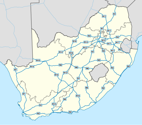
English: Map of South Africa showing the roads of the National Route System, with labels. |
| Date | |
| Source | Geodata from OpenStreetMap |
| Auteur | Htonl |
| Autres versions | File:Map of the National Roads of South Africa.svg, File:Map of the National Roads of South Africa with labels and cities.svg |
| SVG information |
Conditions d’utilisation
Ce fichier est disponible selon les termes de la licence Creative Commons Attribution – Partage dans les Mêmes Conditions 3.0 (non transposée).
- Vous êtes libre :
- de partager – de copier, distribuer et transmettre cette œuvre
- d’adapter – de modifier cette œuvre
- Sous les conditions suivantes :
- paternité – Vous devez donner les informations appropriées concernant l'auteur, fournir un lien vers la licence et indiquer si des modifications ont été faites. Vous pouvez faire cela par tout moyen raisonnable, mais en aucune façon suggérant que l’auteur vous soutient ou approuve l’utilisation que vous en faites.
- partage à l’identique – Si vous modifiez, transformez, ou vous basez sur cette œuvre, vous devez distribuer votre contribution sous la même licence ou une licence compatible avec celle de l’original.
| Ce travail contient des informations issues de OpenStreetMap mises à disposition sous les termes de la Licence Open Database (ODbL).
L'ODbL n'exige aucune licence en particulier pour les cartes produites à partir de données placées sous l'ODbL. Avant le 1er août 2020, les tuiles des cartes produites par la Fondation OpenStreetMap étaient placées sous la licence CC-BY-SA-2.0. Les cartes produites par d'autres personnes peuvent être placées sous des licences différentes. |
Historique du fichier
Cliquer sur une date et heure pour voir le fichier tel qu'il était à ce moment-là.
| Date et heure | Vignette | Dimensions | Utilisateur | Commentaire | |
|---|---|---|---|---|---|
| actuel | 1 février 2014 à 20:45 | | 809 × 709 (547 kio) | Htonl | update w/ simpler labels, roads in neighbouring countries, ODbL data |
| 10 décembre 2010 à 21:51 |  | 757 × 660 (1,08 Mio) | Htonl | use appropriate projection; change basemap style | |
| 21 avril 2010 à 05:19 |  | 1 000 × 786 (1,5 Mio) | Htonl | minor SVG tweak | |
| 21 avril 2010 à 05:11 |  | 1 000 × 786 (1,5 Mio) | Htonl | new version based on OSM data | |
| 23 juillet 2009 à 23:26 |  | 1 000 × 786 (2,14 Mio) | Htonl | minor tweaks | |
| 23 juillet 2009 à 22:25 |  | 1 000 × 786 (2,13 Mio) | Htonl | colours, labels, widths | |
| 6 novembre 2008 à 20:05 |  | 1 000 × 786 (2,08 Mio) | Htonl | {{Information |Description={{en|1=Map of South Africa showing the roads of the National Road System, with labels.}} |Source=Own work by uploader |Author=Htonl |Date=2008-11-06 |Permission= |other_versions=[[:Image:Map of the National Roads |
Utilisation du fichier
La page suivante utilise ce fichier :
Usage global du fichier
Les autres wikis suivants utilisent ce fichier :
- Utilisation sur af.wikipedia.org
- Utilisation sur de.wikipedia.org
- Utilisation sur en.wikipedia.org
- Utilisation sur en.wikivoyage.org
- Utilisation sur fy.wikipedia.org
- Utilisation sur it.wikipedia.org
- Utilisation sur ja.wikipedia.org
- Utilisation sur nl.wikipedia.org
- Utilisation sur ro.wikipedia.org
- Utilisation sur uk.wikipedia.org
- Utilisation sur zu.wikipedia.org