
Fichier:Map of the MENA region in 1798.svg

Taille de cet aperçu PNG pour ce fichier SVG : 800 × 522 pixels. Autres résolutions : 320 × 209 pixels | 640 × 417 pixels | 1 024 × 668 pixels | 1 280 × 835 pixels | 2 560 × 1 669 pixels | 1 543 × 1 006 pixels.
Fichier d’origine (Fichier SVG, nominalement de 1 543 × 1 006 pixels, taille : 528 kio)
Ce fichier et sa description proviennent de Wikimedia Commons.
Description
| Description |
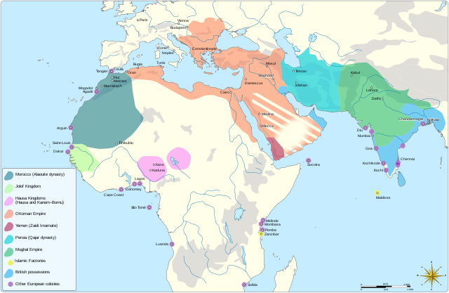
English: Map showing the political entities of the Middle East and North Africa in 1798, namely: the Alaouite dynasty, the Kingdom of Jolof, the Hausa Kingdoms, the Ottoman empire, the Yemeni Zaidi State, the Qajar dynasty and the Mughal Empire. |
| Date | |
| Source |
Travail personnel Information from: |
| Auteur | Goran tek-en, following request by and knowledge from Flaspec |
| Autorisation (Réutilisation de ce fichier) |
Ce fichier est sous la licence Creative Commons Attribution – Partage dans les Mêmes Conditions 4.0 International. Attribution: Goran tek-en
|
| Autres versions |
|
| SVG information | Cette image vectorielle a été créée avec Inkscape. |

| Position de l'objet | | Voir cet endroit et d’autres images sur : OpenStreetMap |
|---|

Historique du fichier
Cliquer sur une date et heure pour voir le fichier tel qu'il était à ce moment-là.
| Date et heure | Vignette | Dimensions | Utilisateur | Commentaire | |
|---|---|---|---|---|---|
| actuel | 4 mai 2021 à 12:03 | | 1 543 × 1 006 (528 kio) | Goran tek-en | Change in legend requested by Flaspec |
| 3 mai 2021 à 11:21 |  | 1 543 × 1 006 (528 kio) | Goran tek-en | {{Information |description ={{en|Map showing the political entities of the Middle East and North Africa in 1798.}} |date =2021-05-03 |source ={{Own}}<br> {{Derived from|امتداد الدولة العلوية سنة 1798م.png|BlankMap-World-Compact.svg}} Information from: * [http://medias.sciences-po.fr/Lexpansion_europeenne_1798/medias/domain2/media0/133-0glgaklmem-whr.jpg 1798] * {{U|Flaspec}} |author =Goran tek-en, following request by... |
Utilisation du fichier
La page suivante utilise ce fichier :
Usage global du fichier
Les autres wikis suivants utilisent ce fichier :
- Utilisation sur ar.wikipedia.org