
Fichier:Map of South Africa with provinces shaded and districts numbered (2011).svg

Taille de cet aperçu PNG pour ce fichier SVG : 684 × 599 pixels. Autres résolutions : 274 × 240 pixels | 548 × 480 pixels | 876 × 768 pixels | 1 168 × 1 024 pixels | 2 337 × 2 048 pixels | 809 × 709 pixels.
Fichier d’origine (Fichier SVG, nominalement de 809 × 709 pixels, taille : 845 kio)
Ce fichier et sa description proviennent de Wikimedia Commons.
.svg?uselang=fr)
W3C-validity not checked.
Description
| Description |
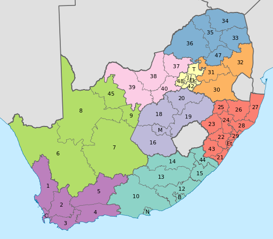
English: Map of South Africa with provincial and district boundaries. The provinces are shaded as follows:
Eastern Cape
Free State
Gauteng
KwaZulu-Natal
Limpopo
Mpumalanga
North West
Northern Cape
Western Cape
The district municipalities are labelled with their code, excluding the letters "DC"; for example, Xhariep District Municipality, which has code DC16, is labelled with a 16. The metropolitan municipalities are labelled with letters. B: Buffalo City; C: City of Cape Town; Ek: Ekurhuleni; Et: eThekwini; J: City of Johannesburg; M: Mangaung; N: Nelson Mandela Bay; T: City of Tshwane. |
| Date | |
| Source | Travail personnel |
| Auteur | Htonl |
| Autres versions | File:Map of South Africa with district borders (2011).svg |
.svg)
Conditions d’utilisation
Moi, en tant que détenteur des droits d’auteur sur cette œuvre, je la publie sous les licences suivantes :
Ce fichier est disponible selon les termes de la licence Creative Commons Attribution – Partage dans les Mêmes Conditions 3.0 (non transposée).
- Vous êtes libre :
- de partager – de copier, distribuer et transmettre cette œuvre
- d’adapter – de modifier cette œuvre
- Sous les conditions suivantes :
- paternité – Vous devez donner les informations appropriées concernant l'auteur, fournir un lien vers la licence et indiquer si des modifications ont été faites. Vous pouvez faire cela par tout moyen raisonnable, mais en aucune façon suggérant que l’auteur vous soutient ou approuve l’utilisation que vous en faites.
- partage à l’identique – Si vous modifiez, transformez, ou vous basez sur cette œuvre, vous devez distribuer votre contribution sous la même licence ou une licence compatible avec celle de l’original.

|
Vous avez la permission de copier, distribuer et modifier ce document selon les termes de la GNU Free Documentation License version 1.2 ou toute version ultérieure publiée par la Free Software Foundation, sans sections inaltérables, sans texte de première page de couverture et sans texte de dernière page de couverture. Un exemplaire de la licence est inclus dans la section intitulée GNU Free Documentation License. |
Vous pouvez choisir l’une de ces licences.
Historique du fichier
Cliquer sur une date et heure pour voir le fichier tel qu'il était à ce moment-là.
| Date et heure | Vignette | Dimensions | Utilisateur | Commentaire | |
|---|---|---|---|---|---|
| actuel | 2 mai 2011 à 13:48 | | 809 × 709 (845 kio) | Htonl | fix numbers |
| 2 mai 2011 à 04:57 |  | 809 × 709 (844 kio) | Htonl | swap FS and GT colours | |
| 16 avril 2011 à 19:49 |  | 809 × 709 (844 kio) | Htonl | {{Information |Description ={{en|1=Map of South Africa with provincial and district boundaries. The provinces are shaded as follows: {{legend|#8DD3C7|Eastern Cape}} {{legend|#FFFFB3|Free State}} {{legend|#BEBADA|Gauteng}} {{legend|#FB8072|KwaZulu-Natal |
Utilisation du fichier
La page suivante utilise ce fichier :
Usage global du fichier
Les autres wikis suivants utilisent ce fichier :
- Utilisation sur af.wikipedia.org
- Utilisation sur de.wikipedia.org
- Utilisation sur en.wikipedia.org
- Utilisation sur es.wikipedia.org
- Utilisation sur hi.wikipedia.org
- Utilisation sur id.wikipedia.org
- Utilisation sur ja.wikipedia.org
- Utilisation sur nl.wikipedia.org
- Utilisation sur tn.wikipedia.org
.svg)