
Fichier:Map of Shootings at Kent State University in 1970.jpg
Taille de cet aperçu : 770 × 600 pixels. Autres résolutions : 308 × 240 pixels | 616 × 480 pixels | 986 × 768 pixels | 1 200 × 935 pixels.
Fichier d’origine (1 200 × 935 pixels, taille du fichier : 364 kio, type MIME : image/jpeg)
Ce fichier et sa description proviennent de Wikimedia Commons.
Description
| Description |
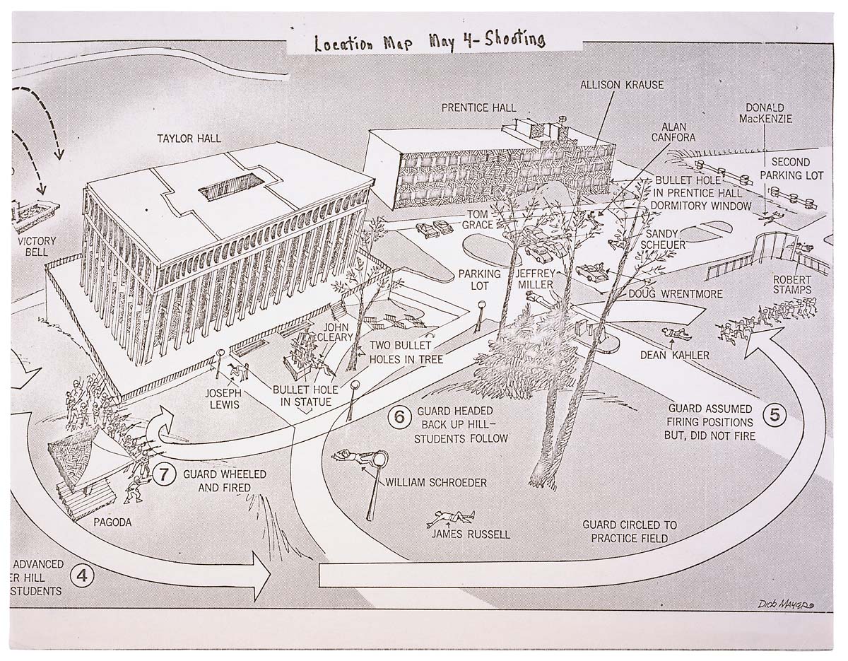
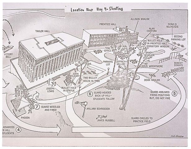
English: This is a printed map detailing the locations of structures, troop movements, bullet hole locations, and locations of casualties at the Kent State shooting of May 4, 1970. |
|||
| Date | 5/04/1970 | |||
| Source | https://catalog.archives.gov/id/596837 | |||
| Auteur | President (1969-1974 : Nixon). President's Commission on Campus Unrest. | |||
| Autorisation (Réutilisation de ce fichier) |
|
Conditions d’utilisation
Ce média est dans le domaine public des États-Unis d’Amérique car son auteur est l’administration américaine comme précisé dans le code fédéral au Titre 17, Chapitre 1, Section 105. Pour en savoir plus : droit d’auteur.
Attention : Ceci ne concerne que le travail du Gouvernement Fédéral et pas celui des États, ou d’une autre subdivision géographique ou politique du pays.
|
 | |
| Ce fichier a été identifié comme étant exempt de restrictions connues liées au droit d’auteur, y compris tous les droits connexes et voisins. | ||
Historique du fichier
Cliquer sur une date et heure pour voir le fichier tel qu'il était à ce moment-là.
| Date et heure | Vignette | Dimensions | Utilisateur | Commentaire | |
|---|---|---|---|---|---|
| actuel | 9 juin 2008 à 03:26 | | 1 200 × 935 (364 kio) | Goldfishbutt | {{Information |Description={{en|1=This is a printed map detailing the locations of structures, troop movements, bullet hole locations, and locations of casualties at the Kent State shooting of May 4, 1970.}} |Source=http://arcweb.archives.gov/arc/arch_res |
Utilisation du fichier
La page suivante utilise ce fichier :
Usage global du fichier
Les autres wikis suivants utilisent ce fichier :
- Utilisation sur af.wikipedia.org
- Utilisation sur de.wikipedia.org
- Utilisation sur en.wikipedia.org
- Utilisation sur en.wikibooks.org
- Utilisation sur en.wikiquote.org
- Utilisation sur he.wikipedia.org
- Utilisation sur it.wikipedia.org
- Utilisation sur ja.wikipedia.org
- Utilisation sur nl.wikipedia.org
- Utilisation sur no.wikipedia.org
- Utilisation sur sv.wikipedia.org
- Utilisation sur zh.wikipedia.org