
Fichier:Map of Poland and Lithuania (1618-1667).svg

Taille de cet aperçu PNG pour ce fichier SVG : 750 × 599 pixels. Autres résolutions : 300 × 240 pixels | 601 × 480 pixels | 961 × 768 pixels | 1 280 × 1 023 pixels | 2 560 × 2 046 pixels | 1 205 × 963 pixels.
Fichier d’origine (Fichier SVG, nominalement de 1 205 × 963 pixels, taille : 116 kio)
Ce fichier et sa description proviennent de Wikimedia Commons.
.svg?uselang=fr)
| Description |
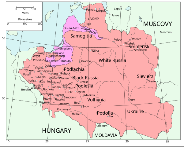
English: Map of Poland and Lithuania following the Union of Lublin in 1569.
|
||
| Date | (UTC) | ||
| Source | Map of Poland and Lithuania after the Union of Lublin (1569).jpg | ||
| Auteur |
|
||
| SVG information | Le code de ce fichier SVG n'est pas valide en raison d'une erreur. Cette carte SVG utilise du texte encapsulé qui peut être traduit facilement à l'aide d'un éditeur de texte.
|
.jpg)
Ce fichier est disponible selon les termes de la licence Creative Commons Attribution – Partage dans les Mêmes Conditions 3.0 (non transposée).
- Vous êtes libre :
- de partager – de copier, distribuer et transmettre cette œuvre
- d’adapter – de modifier cette œuvre
- Sous les conditions suivantes :
- paternité – Vous devez donner les informations appropriées concernant l'auteur, fournir un lien vers la licence et indiquer si des modifications ont été faites. Vous pouvez faire cela par tout moyen raisonnable, mais en aucune façon suggérant que l’auteur vous soutient ou approuve l’utilisation que vous en faites.
- partage à l’identique – Si vous modifiez, transformez, ou vous basez sur cette œuvre, vous devez distribuer votre contribution sous la même licence ou une licence compatible avec celle de l’original.
| File | Type | Details |
|---|---|---|
| File:Polish-Lithuania map (1450-1600).svg | Large SVG | Map showing conflicts and territorial changes on the Polish-Lithuanian—Russian border, 1450–1600 |
| File:Duchy of Prussia.svg | Small SVG | Map of the Duchy of Prussia |
| File:Livonian war map (1558-1560).svg | Small SVG | Map showing campaigns in Livonia, 1558–1560. |
| File:Map of Poland and Lithuania after the Union of Lublin (1569).svg | Large SVG | Map of the w:Polish-Lithuanian Commonwealth after the Union of Lublin in 1569. |
| File:Livonian war map (1570-1577).svg | Small SVG | Map showing areas of Russian and Polish-Lithuanian forces, 1570–1577. |
| File:Campaigns of Stefan Batory.svg | Small SVG | Map of the campaign of Stefan Batory in Livonia (1575–1580). |
| File:Map of Poland and Lithuania in 1600.svg | Small SVG | Map of Livonia in 1600 |
| See also: User:Halibutt/maps, by Halibutt (d · contributions). | ||
.svg)
.svg)
.svg)
.svg)
Journal des téléversements d’origine
This image is a derivative work of the following images:
- Map of Poland and Lithuania after the Union of Lublin (1569).jpg licensed with PD-1923, PD-UK-unknown
- 2011-04-12T13:13:53Z Grandiose 1660x1027 (1008090 Bytes) Improve colouring.
- 2011-04-12T12:58:38Z Grandiose 1660x1027 (402170 Bytes) {{Information |Description ={{en|1=Map of Poland and Lithuania following the Union of Lublin in 1569. Taken from "The Cambridge Modern History Atlas", 1912, London: Cambridge University Press. Editors were Sir Adolphus W
Historique du fichier
Cliquer sur une date et heure pour voir le fichier tel qu'il était à ce moment-là.
| Date et heure | Vignette | Dimensions | Utilisateur | Commentaire | |
|---|---|---|---|---|---|
| actuel | 9 mai 2011 à 18:44 | | 1 205 × 963 (116 kio) | Grandiose | Done my best on the Swedish coastline |
| 14 avril 2011 à 12:29 |  | 1 205 × 963 (116 kio) | Grandiose | A couple more places, Duchy statuses. | |
| 13 avril 2011 à 19:05 |  | 1 205 × 963 (117 kio) | Grandiose | {{Information |Description={{en|1=Map of Poland and Lithuania following the Union of Lublin in 1569. Adapted from "The Cambridge Modern History Atlas", 1912, London: Cambridge University Press. (See source file for more information.)}} |Source=*[[:File:M |
Utilisation du fichier
La page suivante utilise ce fichier :
Usage global du fichier
Les autres wikis suivants utilisent ce fichier :
- Utilisation sur ca.wikipedia.org
- Utilisation sur de.wikipedia.org
- Utilisation sur uk.wikipedia.org
.svg)