
Fichier:Map of Blackford County, Indiana.svg

Taille de cet aperçu PNG pour ce fichier SVG : 600 × 600 pixels. Autres résolutions : 240 × 240 pixels | 480 × 480 pixels | 768 × 768 pixels | 1 024 × 1 024 pixels | 2 048 × 2 048 pixels.
Fichier d’origine (Fichier SVG, nominalement de 768 × 768 pixels, taille : 508 kio)
Ce fichier et sa description proviennent de Wikimedia Commons.
Description
| Description |
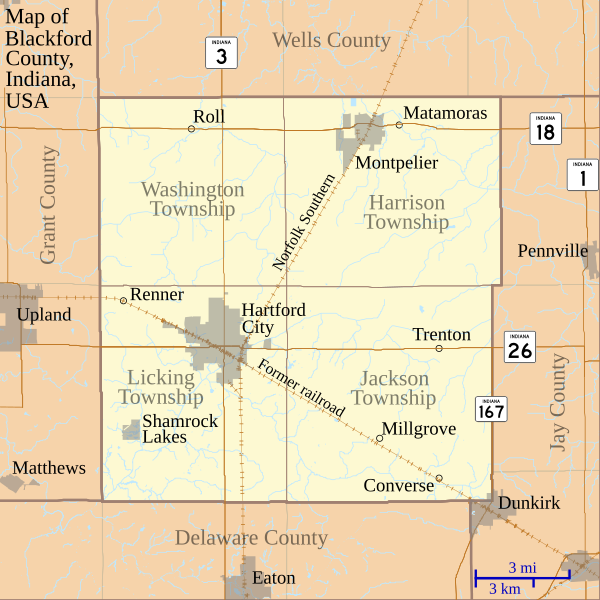
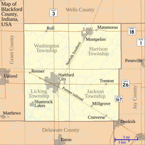
English: This is a map of Blackford County, Indiana, USA which shows settlements, county and township borders, and major transportation routes. |
| Date | |
| Source | My own work, using custom-written MapScript applications with freely-available United States Census Bureau TIGER data |
| Auteur | Omnedon |
Conditions d’utilisation
| Moi, propriétaire des droits d’auteur sur cette œuvre, la place dans le domaine public. Ceci s'applique dans le monde entier. Dans certains pays, ceci peut ne pas être possible ; dans ce cas : J’accorde à toute personne le droit d’utiliser cette œuvre dans n’importe quel but, sans aucune condition, sauf celles requises par la loi. |
Historique du fichier
Cliquer sur une date et heure pour voir le fichier tel qu'il était à ce moment-là.
| Date et heure | Vignette | Dimensions | Utilisateur | Commentaire | |
|---|---|---|---|---|---|
| actuel | 3 juillet 2011 à 00:49 | | 768 × 768 (508 kio) | Omnedon | == {{int:filedesc}} == {{Information |Description={{en|This is a map of Blackford County, Indiana, USA which shows settlements, county and township borders, and major transportation routes.}} |Source=My own work, using cus |
| 20 juin 2011 à 06:14 |  | 768 × 768 (506 kio) | Omnedon | == {{int:filedesc}} == {{Information |Description={{en|This is a map of Blackford County, Indiana, USA which includes incorporated settlement and township borders.}} |Source=My own work, using custom-written [http://www.ma | |
| 18 février 2008 à 01:28 |  | 768 × 768 (29 kio) | Omnedon | {{Information |Description={{en|This is a map of Blackford County, Indiana, USA which shows settlements, townships, roads, railroads, and major rivers.}} |Source=My own work, using freely-available shape data and custom-written MapScript applications |Dat |
Utilisation du fichier
La page suivante utilise ce fichier :
Usage global du fichier
Les autres wikis suivants utilisent ce fichier :
- Utilisation sur ar.wikipedia.org
- Utilisation sur ceb.wikipedia.org
- Utilisation sur en.wikipedia.org
- Blackford County, Indiana
- Converse, Blackford County, Indiana
- Matamoras, Indiana
- Millgrove, Indiana
- Renner, Indiana
- Roll, Indiana
- Trenton, Indiana
- History of Hartford City, Indiana
- First Presbyterian Church (Hartford City, Indiana)
- Hartford City Courthouse Square Historic District
- Blackford County Courthouse
- Module:Location map/data/USA Indiana Blackford County/doc
- Montpelier Carnegie Library
- Module:Location map/data/USA Indiana Blackford County
- Utilisation sur es.wikipedia.org
- Utilisation sur fa.wikipedia.org
- Utilisation sur kn.wikipedia.org
- Utilisation sur nl.wikipedia.org
- Utilisation sur ro.wikipedia.org
- Utilisation sur si.wikipedia.org
- Utilisation sur tr.wikipedia.org
- Utilisation sur war.wikipedia.org