
Fichier:Map of Battle of Cochin (1504) Pass of Cambalão.gif
Taille de cet aperçu : 347 × 599 pixels. Autres résolutions : 139 × 240 pixels | 429 × 740 pixels.
Fichier d’origine (429 × 740 pixels, taille du fichier : 57 kio, type MIME : image/gif)
Ce fichier et sa description proviennent de Wikimedia Commons.
_Pass_of_Cambal%C3%A3o.gif?uselang=fr)
Description
| Description |
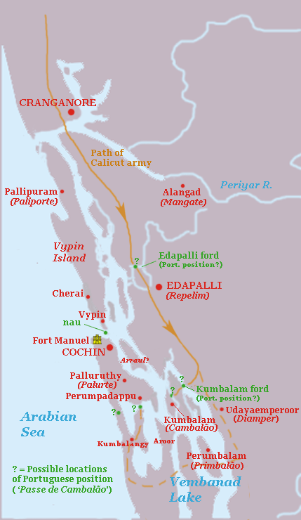
English: Map indicating some possible positions of the ' Pass of Cambalão', the position where the Portuguese force under Duarte Pacheco Pereira held against the Zamorin of Calicut during the Battle of Cochin in April, 1504. The map is highly conjectural, based roughly on the modern geography of Kochi and Vembanad lake, which has probably changed substantially since the 16th C. Green dots = possible locations of the Portuguese position, Straight line = most probable route of Calicut army; Dotted line = alternative longer route for army of Calicut. |
| Date | |
| Source | Travail personnel |
| Auteur | Walrasiad |
Conditions d’utilisation
Moi, en tant que détenteur des droits d’auteur sur cette œuvre, je la publie sous la licence suivante :
Ce fichier est disponible selon les termes de la licence Creative Commons Attribution – Partage dans les Mêmes Conditions 3.0 (non transposée).
- Vous êtes libre :
- de partager – de copier, distribuer et transmettre cette œuvre
- d’adapter – de modifier cette œuvre
- Sous les conditions suivantes :
- paternité – Vous devez donner les informations appropriées concernant l'auteur, fournir un lien vers la licence et indiquer si des modifications ont été faites. Vous pouvez faire cela par tout moyen raisonnable, mais en aucune façon suggérant que l’auteur vous soutient ou approuve l’utilisation que vous en faites.
- partage à l’identique – Si vous modifiez, transformez, ou vous basez sur cette œuvre, vous devez distribuer votre contribution sous la même licence ou une licence compatible avec celle de l’original.
Historique du fichier
Cliquer sur une date et heure pour voir le fichier tel qu'il était à ce moment-là.
| Date et heure | Vignette | Dimensions | Utilisateur | Commentaire | |
|---|---|---|---|---|---|
| actuel | 8 août 2010 à 13:13 | | 429 × 740 (57 kio) | Walrasiad | {{Information |Description={{en|1=Map indicating some possible positions of the ' Pass of Cambalão', the position where the Portuguese force under Duarte Pacheco Pereira held against the Zamorin of Calicut during the Battle of Cochin in April, 1504. |
Utilisation du fichier
La page suivante utilise ce fichier :
Usage global du fichier
Les autres wikis suivants utilisent ce fichier :
- Utilisation sur en.wikipedia.org
- Utilisation sur it.wikipedia.org
_Pass_of_Cambalão.gif)