
Fichier:Map2013.jpg

Taille de cet aperçu : 800 × 549 pixels. Autres résolutions : 320 × 220 pixels | 640 × 439 pixels | 1 094 × 751 pixels.
Fichier d’origine (1 094 × 751 pixels, taille du fichier : 221 kio, type MIME : image/jpeg)
Ce fichier et sa description proviennent de Wikimedia Commons.
Description
| Description |
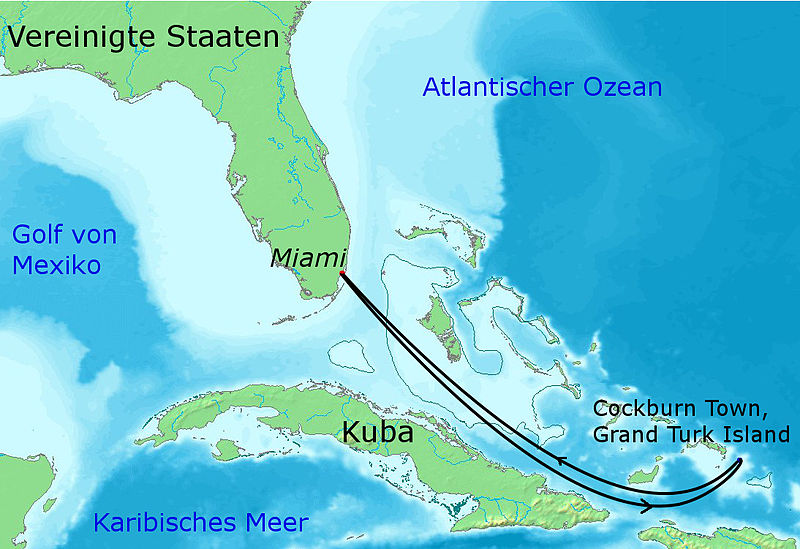
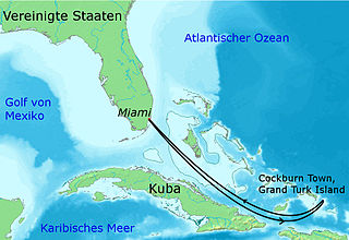
English: Map of the Caribbean showing the route of the Majesty of the Seas at the 70000 Tons of Metal Festival 2013 |
| Date | |
| Source |
Ce fichier est dérivé de : |
| Auteur |
|


| Cette image a été retouchée, ce qui signifie qu'elle a été modifiée par ordinateur et est différente de l'image d'origine. Liste des modifications : composed and route added. L'image d'origine se trouve ici : Topographic30deg N30W60.png:
|
Conditions d’utilisation
Ce fichier est disponible selon les termes de la licence Creative Commons Attribution – Partage dans les Mêmes Conditions 3.0 (non transposée).
- Vous êtes libre :
- de partager – de copier, distribuer et transmettre cette œuvre
- d’adapter – de modifier cette œuvre
- Sous les conditions suivantes :
- paternité – Vous devez donner les informations appropriées concernant l'auteur, fournir un lien vers la licence et indiquer si des modifications ont été faites. Vous pouvez faire cela par tout moyen raisonnable, mais en aucune façon suggérant que l’auteur vous soutient ou approuve l’utilisation que vous en faites.
- partage à l’identique – Si vous modifiez, transformez, ou vous basez sur cette œuvre, vous devez distribuer votre contribution sous la même licence ou une licence compatible avec celle de l’original.
Journal des téléversements d’origine
This image is a derivative work of the following images:
- File:Topographic30deg_N0W60.png licensed with PD-Demis
- 2005-05-26T17:28:09Z Koba-chan 1800x1800 (926487 Bytes) ---- Map created from [http://www2.demis.nl/mapserver/mapper.asp DEMIS Mapserver], which are public domain. [[User:Koba-chan|Koba-chan]] {{GFDL}} [[Category:Topographic maps]] [[Category:Earth]]
- File:Topographic30deg_N0W90.png licensed with Cc-by-sa-3.0-migrated, GFDL
- 2005-05-26T17:23:38Z Koba-chan 1800x1800 (903228 Bytes) ---- Map created from [http://www2.demis.nl/mapserver/mapper.asp DEMIS Mapserver], which are public domain. [[User:Koba-chan|Koba-chan]] {{GFDL}} [[Category:Topographic maps]] [[Category:Earth]]
- File:Topographic30deg_N30W60.png licensed with Cc-by-sa-3.0-migrated, GFDL
- 2005-05-26T17:42:25Z Koba-chan 1800x1800 (885775 Bytes) ---- Map created from [http://www2.demis.nl/mapserver/mapper.asp DEMIS Mapserver], which are public domain. [[User:Koba-chan|Koba-chan]] {{GFDL}} [[Category:Topographic maps]] [[Category:Earth]]
Historique du fichier
Cliquer sur une date et heure pour voir le fichier tel qu'il était à ce moment-là.
| Date et heure | Vignette | Dimensions | Utilisateur | Commentaire | |
|---|---|---|---|---|---|
| actuel | 15 mai 2013 à 17:59 | | 1 094 × 751 (221 kio) | Trollhead | == {{int:filedesc}} == {{Information |Description=== {{en|1=Map of the Caribbean showing the route of the Majesty of the Seas at the 70000 Tons of Metal Festival 2013}} |Source={{Derived from|Topographic30deg_N0W60.png|Topographic30deg_N0W90.png|Topogr... |
Utilisation du fichier
La page suivante utilise ce fichier :
Usage global du fichier
Les autres wikis suivants utilisent ce fichier :
- Utilisation sur de.wikipedia.org
- Utilisation sur en.wikipedia.org
- Utilisation sur es.wikipedia.org
- Utilisation sur hu.wikipedia.org
- Utilisation sur nl.wikipedia.org
- Utilisation sur no.wikipedia.org