
Fichier:Map-position-klaksvikar-kommuna-2008.png

Taille de cet aperçu : 450 × 600 pixels. Autres résolutions : 180 × 240 pixels | 600 × 800 pixels.
Fichier d’origine (600 × 800 pixels, taille du fichier : 32 kio, type MIME : image/png)
Ce fichier et sa description proviennent de Wikimedia Commons.
Description
| Description |
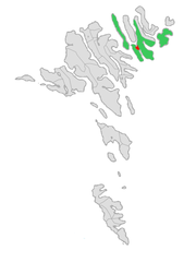
English: Map of the municipality of Klaksvík in the Faroe Islands, updated with the merger between the municipalities of Klaksvík and Svínoy in November 2008.
Norsk bokmål: Kart over kommunen Klaksvík på Færøyene, oppdatert med sammenslåingen mellom kommunene Klaksvík og Svínoy i november 2008. |
| Date | |
| Source | Travail personnel |
| Auteur | Erik Fløan |
| Autres versions |
 |
Conditions d’utilisation
Moi, en tant que détenteur des droits d’auteur sur cette œuvre, je la publie sous les licences suivantes :

|
Vous avez la permission de copier, distribuer et modifier ce document selon les termes de la GNU Free Documentation License version 1.2 ou toute version ultérieure publiée par la Free Software Foundation, sans sections inaltérables, sans texte de première page de couverture et sans texte de dernière page de couverture. Un exemplaire de la licence est inclus dans la section intitulée GNU Free Documentation License. |
Ce fichier est sous licence Creative Commons Attribution – Partage dans les Mêmes Conditions 3.0 (non transposée), 2.5 Générique, 2.0 Générique et 1.0 Générique.
- Vous êtes libre :
- de partager – de copier, distribuer et transmettre cette œuvre
- d’adapter – de modifier cette œuvre
- Sous les conditions suivantes :
- paternité – Vous devez donner les informations appropriées concernant l'auteur, fournir un lien vers la licence et indiquer si des modifications ont été faites. Vous pouvez faire cela par tout moyen raisonnable, mais en aucune façon suggérant que l’auteur vous soutient ou approuve l’utilisation que vous en faites.
- partage à l’identique – Si vous modifiez, transformez, ou vous basez sur cette œuvre, vous devez distribuer votre contribution sous la même licence ou une licence compatible avec celle de l’original.
Vous pouvez choisir l’une de ces licences.
Historique du fichier
Cliquer sur une date et heure pour voir le fichier tel qu'il était à ce moment-là.
| Date et heure | Vignette | Dimensions | Utilisateur | Commentaire | |
|---|---|---|---|---|---|
| actuel | 23 août 2019 à 15:04 | | 600 × 800 (32 kio) | Vman81 | Updated to reflect Húsar kommuna merging with Klaksvík on January 1 2018 |
| 9 décembre 2008 à 19:00 |  | 600 × 800 (33 kio) | Efloean | == Beskrivelse == {{Information |Description={{en|1=Map of the municipality of Klaksvík in the Faroe Islands, updated with the merger between the municipalities of Klaksvík and Svínoy in November 2008.}} {{no|1=Kart over kommunen Klaksvík på Færøye | |
| 9 décembre 2008 à 18:55 |  | 600 × 800 (33 kio) | Efloean | {{Information |Description={{en|1=Map of the municipality of Klaksvík in the Faroe Islands, updated with the merger between the municipalities of Klaksvík and Svínoy in November 2008.}} {{no|1=Kart over kommunen Klaksvík på Færøyene, oppdatert med |
Utilisation du fichier
La page suivante utilise ce fichier :
Usage global du fichier
Les autres wikis suivants utilisent ce fichier :
- Utilisation sur ca.wikipedia.org
- Utilisation sur da.wikipedia.org
- Utilisation sur fa.wikipedia.org
- Utilisation sur fo.wikipedia.org
- Utilisation sur hu.wikipedia.org
- Utilisation sur nl.wikipedia.org
- Utilisation sur pl.wikipedia.org
- Utilisation sur ru.wikipedia.org
- Utilisation sur sco.wikipedia.org
- Utilisation sur sv.wikipedia.org
- Utilisation sur ur.wikipedia.org
- Utilisation sur vi.wikipedia.org
- Utilisation sur www.wikidata.org