
Fichier:Louvre Access Map.png
Taille de cet aperçu : 800 × 533 pixels. Autres résolutions : 320 × 213 pixels | 640 × 427 pixels | 1 024 × 682 pixels | 1 280 × 853 pixels | 2 000 × 1 333 pixels.
Fichier d’origine (2 000 × 1 333 pixels, taille du fichier : 2,17 Mio, type MIME : image/png)
Ce fichier et sa description proviennent de Wikimedia Commons.
Description
| Description |
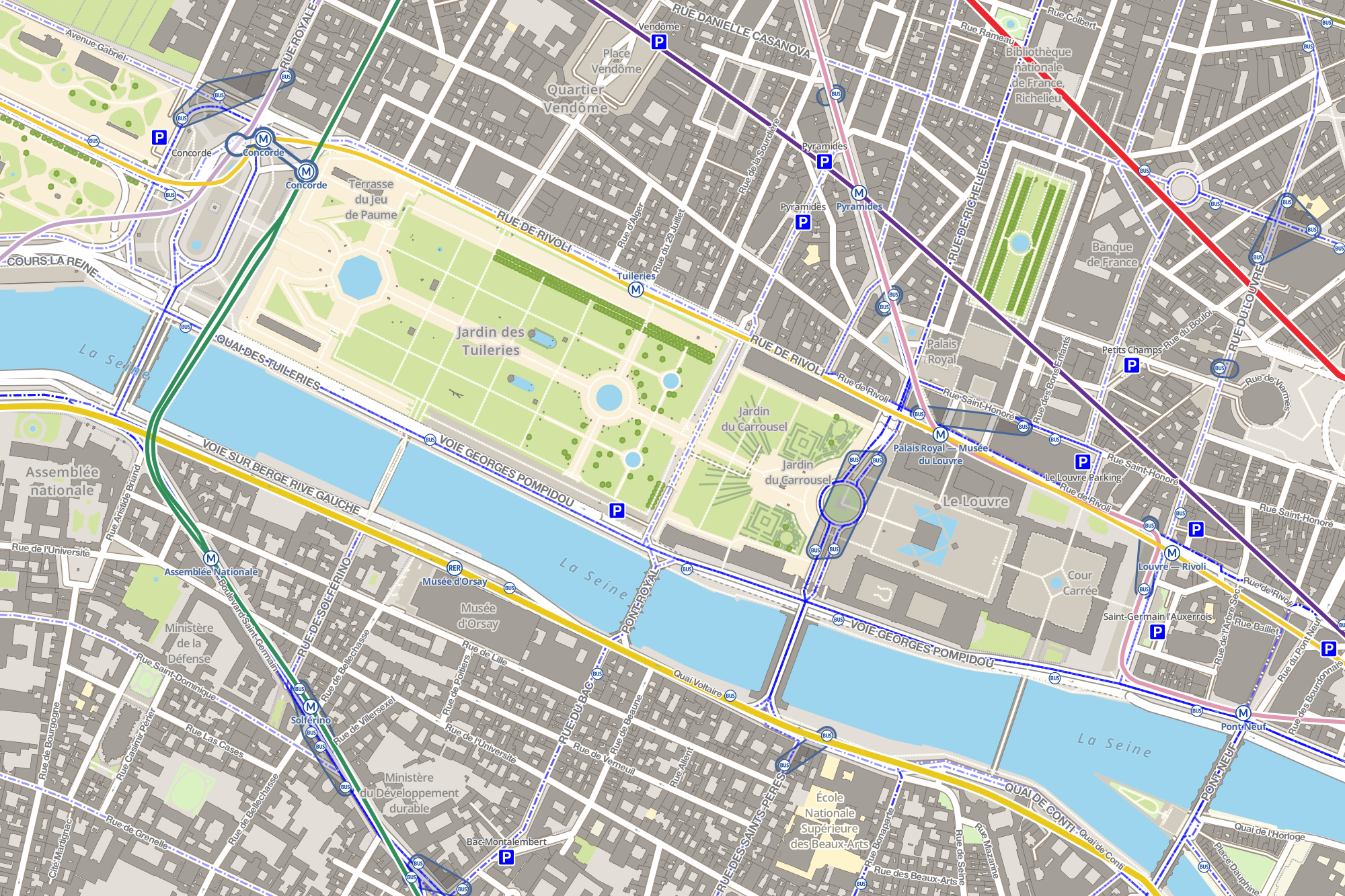
Français : Carte montrant les stations de métro, de bus et les parcs de stationnements autour du musée du Louvre de Paris. Cette carte est réalisée grâce aux données d'OpenStreetMap et grâce aux logiciels libres TileMill, PostgreSQL, PostGIS et osm2pgsql. Les logos RATP de la carte proviennent de File:Metro-M.svg et File:Paris_logo_bus_jms.svg. |
| Date | |
| Source | Travail personnel |
| Auteur | Benh LIEU SONG |
Conditions d’utilisation
Moi, en tant que détenteur des droits d’auteur sur cette œuvre, je la publie sous la licence suivante :
Ce fichier est disponible selon les termes de la licence Creative Commons Attribution – Partage dans les Mêmes Conditions 3.0 (non transposée).
- Vous êtes libre :
- de partager – de copier, distribuer et transmettre cette œuvre
- d’adapter – de modifier cette œuvre
- Sous les conditions suivantes :
- paternité – Vous devez donner les informations appropriées concernant l'auteur, fournir un lien vers la licence et indiquer si des modifications ont été faites. Vous pouvez faire cela par tout moyen raisonnable, mais en aucune façon suggérant que l’auteur vous soutient ou approuve l’utilisation que vous en faites.
- partage à l’identique – Si vous modifiez, transformez, ou vous basez sur cette œuvre, vous devez distribuer votre contribution sous la même licence ou une licence compatible avec celle de l’original.
Historique du fichier
Cliquer sur une date et heure pour voir le fichier tel qu'il était à ce moment-là.
| Date et heure | Vignette | Dimensions | Utilisateur | Commentaire | |
|---|---|---|---|---|---|
| actuel | 30 novembre 2012 à 12:43 | | 2 000 × 1 333 (2,17 Mio) | Benh | Added many missing bus stops (in OpenStreetMap), grouped bus stops with same name, added interchange lines between metro stations with same name. |
| 28 novembre 2012 à 16:50 |  | 2 000 × 1 335 (2,14 Mio) | Benh | Fixed Musée d'Orsay station (metro -> RER) and made text bigger. | |
| 28 novembre 2012 à 15:34 |  | 1 999 × 1 334 (2,12 Mio) | Benh | added metro and RER lines (with color scheme), bus lines (without color scheme to not clutter the map) | |
| 28 novembre 2012 à 02:06 |  | 2 000 × 1 334 (1,98 Mio) | Benh | User created page with UploadWizard |
Utilisation du fichier
La page suivante utilise ce fichier :
Usage global du fichier
Les autres wikis suivants utilisent ce fichier :
- Utilisation sur ar.wikipedia.org
- Utilisation sur ja.wikipedia.org
- Utilisation sur ko.wikipedia.org
- Utilisation sur pt.wikipedia.org