
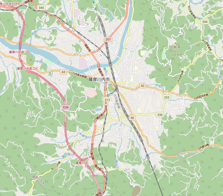
Fichier:Location map Japan Satsumasendai city.png
Taille de cet aperçu : 681 × 600 pixels. Autres résolutions : 273 × 240 pixels | 545 × 480 pixels | 730 × 643 pixels.
Fichier d’origine (730 × 643 pixels, taille du fichier : 491 kio, type MIME : image/png)
Ce fichier et sa description proviennent de Wikimedia Commons.
Description
| Description |
日本語: 薩摩川内市街地地図
English: Map of Satsumasendai city central |
| Date | |
| Source | OpenStreetMap |
| Auteur | OpenStreetMap and contributors |
Conditions d’utilisation
| Ce travail contient des informations issues de OpenStreetMap mises à disposition sous les termes de la Licence Open Database (ODbL).
L'ODbL n'exige aucune licence en particulier pour les cartes produites à partir de données placées sous l'ODbL. Avant le 1er août 2020, les tuiles des cartes produites par la Fondation OpenStreetMap étaient placées sous la licence CC-BY-SA-2.0. Les cartes produites par d'autres personnes peuvent être placées sous des licences différentes. |
Historique du fichier
Cliquer sur une date et heure pour voir le fichier tel qu'il était à ce moment-là.
| Date et heure | Vignette | Dimensions | Utilisateur | Commentaire | |
|---|---|---|---|---|---|
| actuel | 4 février 2021 à 14:56 | | 730 × 643 (491 kio) | Sakoppi | {{Information |description={{ja|1=薩摩川内市街地地図}} {{en|1=Map of Satsumasendai city central}} |date=2021-02-04 |source=OpenStreetMap |author=[http://www.openstreetmap.org OpenStreetMap] and contributors |permission= |other versions= }} =={{int:license-header}}== {{ODbL OpenStreetMap}} Category:OpenStreetMap maps of Japan Category:Location maps of Japan Category:Maps of Kagoshima Prefecture |
Utilisation du fichier
La page suivante utilise ce fichier :
Usage global du fichier
Les autres wikis suivants utilisent ce fichier :
- Utilisation sur ja.wikipedia.org