
Fichier:Link light rail geographic map.svg

Taille de cet aperçu PNG pour ce fichier SVG : 550 × 600 pixels. Autres résolutions : 220 × 240 pixels | 440 × 480 pixels | 705 × 768 pixels | 939 × 1 024 pixels | 1 879 × 2 048 pixels | 1 600 × 1 744 pixels.
Fichier d’origine (Fichier SVG, nominalement de 1 600 × 1 744 pixels, taille : 597 kio)
Ce fichier et sa description proviennent de Wikimedia Commons.
Description

|
Il est attendu que cette image soit la plus récente qui existe. N'hésitez pas à la mettre à jour au besoin.
|
| Description |
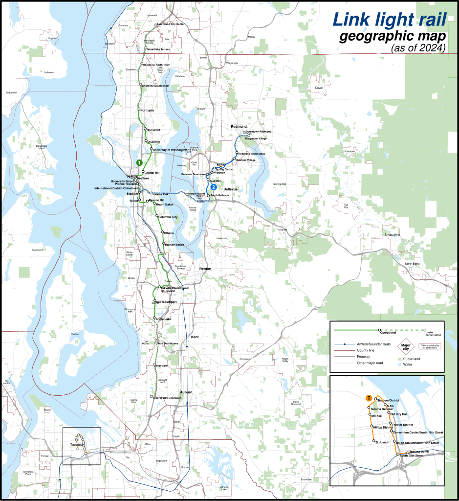
English: A geographically-accurate map of lines of the Link light rail, including parts under construction (dashed in map), overlayed on a basemap containing the Silver Line and commuter rail lines, municipalities, roads, water areas, area landmarks, and green spaces. Shapefiles from the United States Census Bureau, the U.S. Geological Survey (USGS) Gap Analysis Project (GAP), Sound Transit, and OpenStreetMap (© OpenStreetMap contributors), converted with Mapshaper and Inkscape (Mercator projection). |
| Date | |
| Source | Travail personnel |
| Auteur | Twotwofourtysix |
Conditions d’utilisation
Moi, en tant que détenteur des droits d’auteur sur cette œuvre, je la publie sous la licence suivante :
Ce fichier est sous la licence Creative Commons Attribution – Partage dans les Mêmes Conditions 4.0 International.
- Vous êtes libre :
- de partager – de copier, distribuer et transmettre cette œuvre
- d’adapter – de modifier cette œuvre
- Sous les conditions suivantes :
- paternité – Vous devez donner les informations appropriées concernant l'auteur, fournir un lien vers la licence et indiquer si des modifications ont été faites. Vous pouvez faire cela par tout moyen raisonnable, mais en aucune façon suggérant que l’auteur vous soutient ou approuve l’utilisation que vous en faites.
- partage à l’identique – Si vous modifiez, transformez, ou vous basez sur cette œuvre, vous devez distribuer votre contribution sous la même licence ou une licence compatible avec celle de l’original.
Historique du fichier
Cliquer sur une date et heure pour voir le fichier tel qu'il était à ce moment-là.
| Date et heure | Vignette | Dimensions | Utilisateur | Commentaire | |
|---|---|---|---|---|---|
| actuel | 5 mai 2024 à 04:49 | | 1 600 × 1 744 (597 kio) | Twotwofourtysix | Update with opening of line section |
| 4 mai 2024 à 09:58 |  | 1 600 × 1 744 (635 kio) | OrdinaryScarlett | Update date | |
| 4 mai 2024 à 09:01 |  | 1 600 × 1 744 (673 kio) | SounderBruce | Remove CDP "boundaries" that change with every census; cleanup label placement on 2 Line | |
| 1 mai 2024 à 04:41 |  | 1 600 × 1 744 (651 kio) | OrdinaryScarlett | Update 2 Line and Lynnwood and Federal Way Link Extension station names | |
| 19 janvier 2024 à 22:05 |  | 1 600 × 1 744 (690 kio) | SounderBruce | Removing most labels for CDPs, which are arbitrarily assigned by the Census Bureau and change frequently; boundaries should also be deleted at some point | |
| 19 janvier 2024 à 16:18 |  | 1 600 × 1 744 (650 kio) | Twotwofourtysix | Adds legend & title, adjusts colours | |
| 18 janvier 2024 à 17:58 |  | 1 600 × 1 744 (1,76 Mio) | Twotwofourtysix | Uploaded own work with UploadWizard |
Utilisation du fichier
La page suivante utilise ce fichier :
Usage global du fichier
Les autres wikis suivants utilisent ce fichier :
- Utilisation sur ca.wikipedia.org
- Utilisation sur cs.wikipedia.org
- Utilisation sur de.wikipedia.org
- Utilisation sur de.wikivoyage.org
- Utilisation sur en.wikipedia.org
- Utilisation sur es.wikipedia.org
- Utilisation sur fa.wikipedia.org
- Utilisation sur it.wikipedia.org
- Utilisation sur mr.wikipedia.org
- Utilisation sur uk.wikipedia.org
- Utilisation sur www.wikidata.org
- Utilisation sur zh.wikipedia.org