
Fichier:Landsat 8 launch.jpg

Taille de cet aperçu : 480 × 600 pixels. Autres résolutions : 192 × 240 pixels | 384 × 480 pixels | 614 × 768 pixels | 819 × 1 024 pixels | 2 400 × 3 000 pixels.
Fichier d’origine (2 400 × 3 000 pixels, taille du fichier : 994 kio, type MIME : image/jpeg)
Ce fichier et sa description proviennent de Wikimedia Commons.
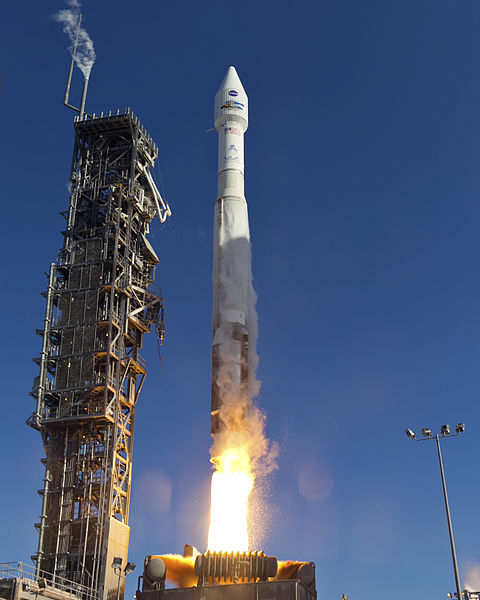
| Description | VANDENBERG AFB, Calif. -- The Landsat Data Continuity Mission spacecraft lifted off on 11 February 2013 at 1:02 p.m. EST (10:02 a.m. PST, 18:02 UTC) atop a United Launch Alliance Atlas V rocket from Space Launch Complex 3 at California's Vandenberg Air Force Base. The Landsat Data Continuity Mission LDCM is the future of Landsat satellites. It will continue to obtain valuable data and imagery to be used in agriculture, education, business, science, and government. The Landsat Program provides repetitive acquisition of high resolution multispectral data of the Earth's surface on a global basis. The data from the Landsat spacecraft constitute the longest record of the Earth's continental surfaces as seen from space. It is a record unmatched in quality, detail, coverage, and value. For more information, visit: http://www.nasa.gov/mission_pages/landsat/main/index.html |
| Date | Prise le 11 février 2013, 18:02 |
| Source | http://mediaarchive.ksc.nasa.gov/detail.cfm?mediaid=64296 (archive link); see also https://images.nasa.gov/details/2013-1435 |
| Auteur | United Launch Alliance/Patrick H. Corkery |
| Autorisation (Réutilisation de ce fichier) |
Per source: "No copyright protection is asserted for this photograph. If a recognizable person appears in this photograph, use for commercial purposes may infringe a right of privacy or publicity. It may not be used to state or imply the endorsement by NASA employees of a commercial product, process or service, or used in any other manner that might mislead. Accordingly, it is requested that if this photograph is used in advertising and other commercial promotion, layout and copy be submitted to NASA prior to release." |
Cette image ou vidéo a été cataloguée par le Kennedy Space Center de la National Aeronautics and Space Administration (NASA) des États-Unis sous Photo ID : KSC-2013-1435.Ce bandeau n’indique rien sur le statut de l’œuvre au regard du droit d'auteur. Un bandeau de droit d’auteur est requis. Voir Commons:À propos des licences pour plus d’informations. Autres langues :
|
Conditions d’utilisation
| Cette œuvre a été placée dans le domaine public par son auteur, United Launch Alliance/Patrick H. Corkery. Ceci s’applique dans le monde entier. Dans certains pays, ceci peut ne pas être possible ; dans ce cas : United Launch Alliance/Patrick H. Corkery accorde à toute personne le droit d’utiliser cette œuvre dans n’importe quel but, sans aucune condition, sauf celles requises par la loi.
|
Historique du fichier
Cliquer sur une date et heure pour voir le fichier tel qu'il était à ce moment-là.
| Date et heure | Vignette | Dimensions | Utilisateur | Commentaire | |
|---|---|---|---|---|---|
| actuel | 12 février 2013 à 16:15 | | 2 400 × 3 000 (994 kio) | WDGraham | {{Information |Description=VANDENBERG AFB, Calif. -- The Landsat Data Continuity Mission spacecraft lifted off at 1:02 p.m. EST, 10:02 a.m. PST) <nowiki>[</nowiki>''sic''<nowiki>]</nowiki> atop a United Launch Alliance Atlas V rocket fr... |
Utilisation du fichier
La page suivante utilise ce fichier :
Usage global du fichier
Les autres wikis suivants utilisent ce fichier :
- Utilisation sur en.wikipedia.org
- Utilisation sur ru.wikipedia.org
- Utilisation sur zh.wikipedia.org