
Fichier:Lakshmi Planum and Siddons Patera PIA00240.jpg

Taille de cet aperçu : 507 × 599 pixels. Autres résolutions : 203 × 240 pixels | 406 × 480 pixels | 650 × 768 pixels | 866 × 1 024 pixels | 1 732 × 2 048 pixels | 3 073 × 3 633 pixels.
Fichier d’origine (3 073 × 3 633 pixels, taille du fichier : 3,76 Mio, type MIME : image/jpeg)
Ce fichier et sa description proviennent de Wikimedia Commons.
Description
| Description |
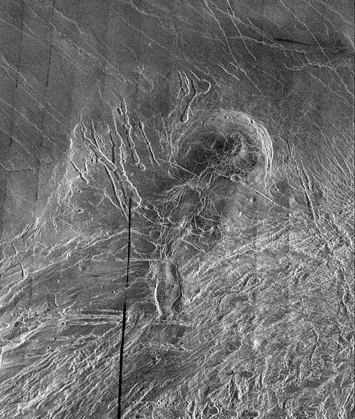
English: This image is a full-resolution mosaic of several Magellan images and is centered at 61 degrees north latitude and 341 degrees east longitude. The image is 250 kilometers wide (150 miles). The radar smooth region in the northern part of the image is Lakshmi Planum, a high plateau region roughly 3.5 kilometers (2.2 miles) above the mean planetary radius. Lakshmi Planum is ringed by intensely deformed terrain, some of which is shown in the southern portion of the image and is called Clotho Tessera. The 64-kilometer (40 mile) diameter circular feature in the image is a depression called Siddons and may be a volcanic caldera. This view is supported by the collapsed lava tubes surrounding the feature. By carefully studying this and other surrounding images scientists hope to discover what tectonic and volcanic processes formed this complex region. The solid black parts of the image represent data gaps that may be filled in by the Magellan extended mission. |
| Source | http://photojournal.jpl.nasa.gov/catalog/PIA00240 |
| Auteur | Galileo probe |
Conditions d’utilisation
| Ce fichier provient de la NASA. Sauf exception, les documents créés par la NASA ne sont pas soumis à copyright. Pour plus d'informations, voir la politique de copyright de la NASA. | ||
 |
Attention :
|
Historique du fichier
Cliquer sur une date et heure pour voir le fichier tel qu'il était à ce moment-là.
| Date et heure | Vignette | Dimensions | Utilisateur | Commentaire | |
|---|---|---|---|---|---|
| actuel | 7 avril 2008 à 07:38 | | 3 073 × 3 633 (3,76 Mio) | Bryan Derksen | {{Information |Description={{en|This image is a full-resolution mosaic of several Magellan images and is centered at 61 degrees north latitude and 341 degrees east longitude. The image is 250 kilometers wide (150 miles). The radar smooth region in the nor |
Utilisation du fichier
Les 2 pages suivantes utilisent ce fichier :
Usage global du fichier
Les autres wikis suivants utilisent ce fichier :
- Utilisation sur be.wikipedia.org
- Utilisation sur bn.wikipedia.org
- Utilisation sur cs.wikipedia.org
- Utilisation sur fi.wikipedia.org
- Utilisation sur hi.wikipedia.org
- Utilisation sur hy.wikipedia.org
- Utilisation sur ja.wikipedia.org
- Utilisation sur nl.wikipedia.org
- Utilisation sur ru.wikipedia.org
- Utilisation sur sr.wikipedia.org
- Utilisation sur ta.wikipedia.org
- Utilisation sur uk.wikipedia.org
- Utilisation sur zh.wikipedia.org