
Fichier:Kashmir Region (2020 skirmish locations).jpg
Taille de cet aperçu : 604 × 599 pixels. Autres résolutions : 242 × 240 pixels | 484 × 480 pixels | 774 × 768 pixels | 1 033 × 1 024 pixels | 1 579 × 1 566 pixels.
Fichier d’origine (1 579 × 1 566 pixels, taille du fichier : 1,27 Mio, type MIME : image/jpeg)
Ce fichier et sa description proviennent de Wikimedia Commons.
.jpg?uselang=fr)
Description
| Description |
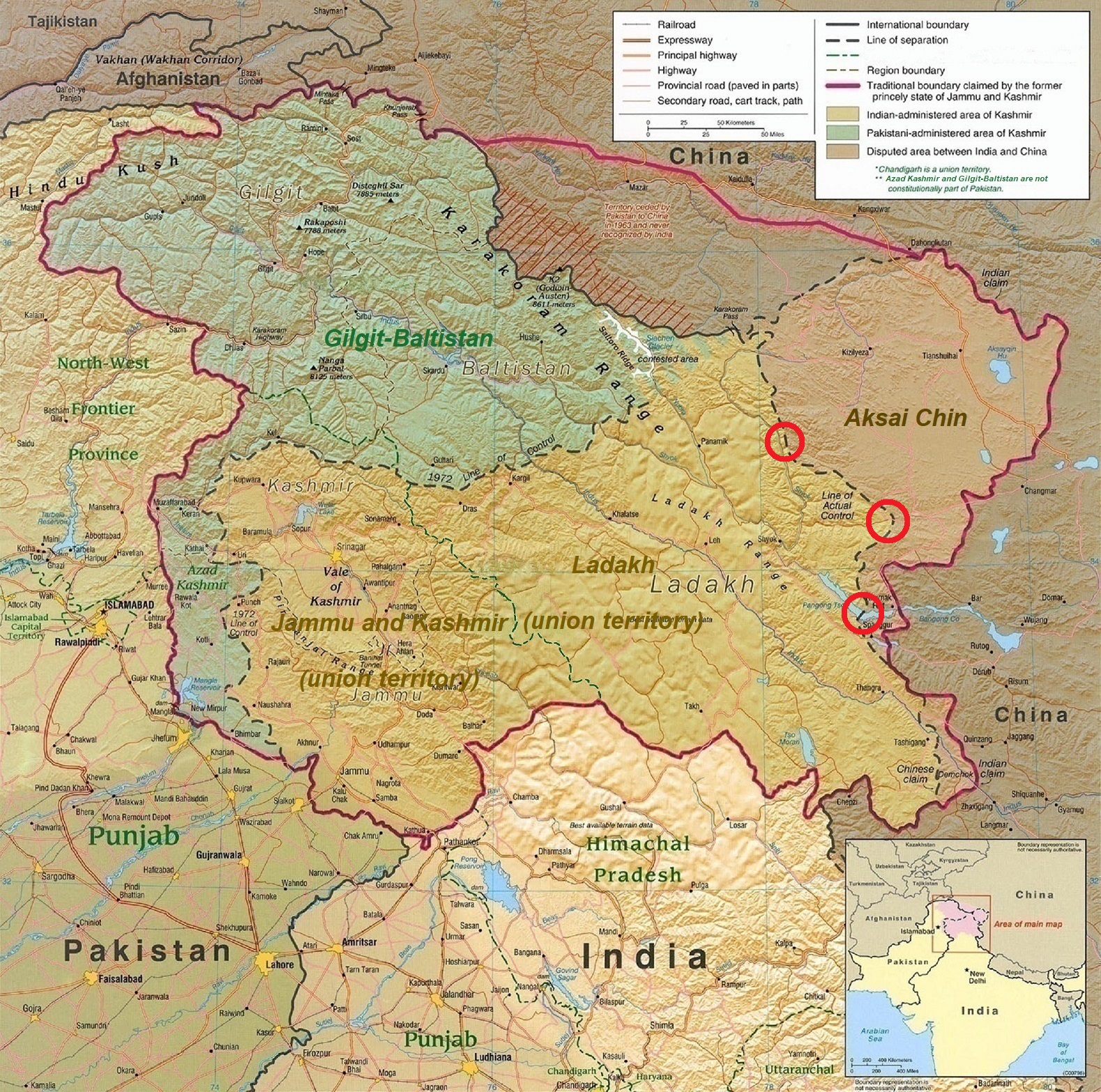
English: A map of the disputed Kashmir region created by the United States CIA in 2004 and hosted by the University of Texas at Austin Perry-Castañeda Library Map Collection; altered to show new jurisdictions by Fowler&fowler in November 2019; altered by to show 2020 skirmish locations by MarkH21 in June 2020. The red circles mark the rough locations of the conflicts at the the Galwan Valley (top), Hot Springs, Chang Chenmo Valley checkpoint (middle), and Pangong Tso (near the bottom). |
| Date | |
| Source | Map of Kashmir region created by the US Central Intelligence Agency, 2004 |
| Auteur | United States Central Intelligence Agency |
| Autres versions |
  |
Conditions d’utilisation
Ce média est dans le domaine public des États-Unis d’Amérique car son auteur est l’administration américaine comme précisé dans le code fédéral au Titre 17, Chapitre 1, Section 105. Pour en savoir plus : droit d’auteur.
Attention : Ceci ne concerne que le travail du Gouvernement Fédéral et pas celui des États, ou d’une autre subdivision géographique ou politique du pays.
|
 | |
| Ce fichier a été identifié comme étant exempt de restrictions connues liées au droit d’auteur, y compris tous les droits connexes et voisins. | ||
| Annotations | Cette image est annotée : Voir les annotations sur Wikimedia Commons |
.jpg)
Historique du fichier
Cliquer sur une date et heure pour voir le fichier tel qu'il était à ce moment-là.
| Date et heure | Vignette | Dimensions | Utilisateur | Commentaire | |
|---|---|---|---|---|---|
| actuel | 24 juin 2020 à 20:45 | | 1 579 × 1 566 (1,27 Mio) | MarkH21 | Removed the Daulat Beg Oldi circle as not being an actual location of conflict; added the Hot Springs, Chang Chenmo Valley circle as an actual location of conflict. |
| 24 juin 2020 à 04:01 |  | 1 579 × 1 566 (1,27 Mio) | MarkH21 | Uploaded a work by United States Central Intelligence Agency, MarkH21 from [https://legacy.lib.utexas.edu/maps/middle_east_and_asia/kashmir_region_2004.jpg Map of Kashmir region] created by the US Central Intelligence Agency, 2004; altered by MarkH21 with UploadWizard |
Utilisation du fichier
La page suivante utilise ce fichier :
Usage global du fichier
Les autres wikis suivants utilisent ce fichier :
- Utilisation sur af.wikipedia.org
- Utilisation sur ca.wikipedia.org
- Utilisation sur en.wikipedia.org
- Utilisation sur es.wikipedia.org
- Utilisation sur fa.wikipedia.org
- Utilisation sur he.wikipedia.org
- Utilisation sur ja.wikipedia.org
- Utilisation sur ka.wikipedia.org
- Utilisation sur ml.wikipedia.org
- Utilisation sur ne.wikipedia.org
- Utilisation sur pnb.wikipedia.org
- Utilisation sur pt.wikipedia.org
- Utilisation sur ru.wikipedia.org
- Utilisation sur simple.wikipedia.org
- Utilisation sur so.wikipedia.org
- Utilisation sur ta.wikipedia.org
- Utilisation sur te.wikipedia.org
- Utilisation sur th.wikipedia.org
- Utilisation sur tr.wikipedia.org
- Utilisation sur uk.wikipedia.org
- Utilisation sur ur.wikipedia.org
- Utilisation sur vi.wikipedia.org
- Utilisation sur www.wikidata.org
- Utilisation sur zh.wikipedia.org
.jpg)