
Fichier:January 2009 Bay of Biscay storm tracker.png
Pas de plus haute résolution disponible.
January_2009_Bay_of_Biscay_storm_tracker.png (650 × 500 pixels, taille du fichier : 173 kio, type MIME : image/png)
Ce fichier et sa description proviennent de Wikimedia Commons.
Description
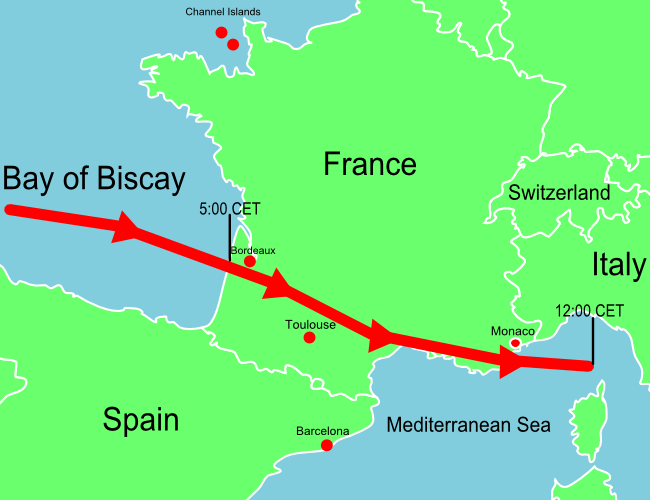
| Description | A map of Europe showing the location of the January 2009 Mediterranean storm. The red line shows the track of the storm. |
| Date | |
| Source | Self-made losely based upon BBC map, but not a derivitive work. |
| Auteur | Jolly Janner |
| Autres versions | The original vector version |
Conditions d’utilisation
| Moi, propriétaire des droits d’auteur sur cette œuvre, la place dans le domaine public. Ceci s'applique dans le monde entier. Dans certains pays, ceci peut ne pas être possible ; dans ce cas : J’accorde à toute personne le droit d’utiliser cette œuvre dans n’importe quel but, sans aucune condition, sauf celles requises par la loi. |
Historique du fichier
Cliquer sur une date et heure pour voir le fichier tel qu'il était à ce moment-là.
| Date et heure | Vignette | Dimensions | Utilisateur | Commentaire | |
|---|---|---|---|---|---|
| actuel | 25 janvier 2009 à 16:07 | 650 × 500 (173 kio) | Jolly Janner | Added Channel Islands and labeled Switzerland | |
| 25 janvier 2009 à 03:11 | 650 × 500 (163 kio) | Jolly Janner | {{Information |Description=A map of Europe showing the location of the January 2009 Mediterranean storm. The red line shows the track of the storm. |Source=Self-made losely based upon [http://newsimg.bbc.co.u |
Utilisation du fichier
La page suivante utilise ce fichier :
Usage global du fichier
Les autres wikis suivants utilisent ce fichier :
- Utilisation sur de.wikinews.org
- Utilisation sur en.wikipedia.org
- Utilisation sur en.wikinews.org
- Utilisation sur es.wikipedia.org
- Utilisation sur eu.wikipedia.org
- Utilisation sur pl.wikipedia.org
- Utilisation sur pl.wikinews.org
- Utilisation sur zh.wikipedia.org