
Fichier:Hainaut centre SNCV openstreetmap.png
Taille de cet aperçu : 426 × 600 pixels. Autres résolutions : 170 × 240 pixels | 341 × 480 pixels | 545 × 768 pixels | 727 × 1 024 pixels | 1 456 × 2 050 pixels.
Fichier d’origine (1 456 × 2 050 pixels, taille du fichier : 2,71 Mio, type MIME : image/png)
Ce fichier et sa description proviennent de Wikimedia Commons.
Description
| Description |
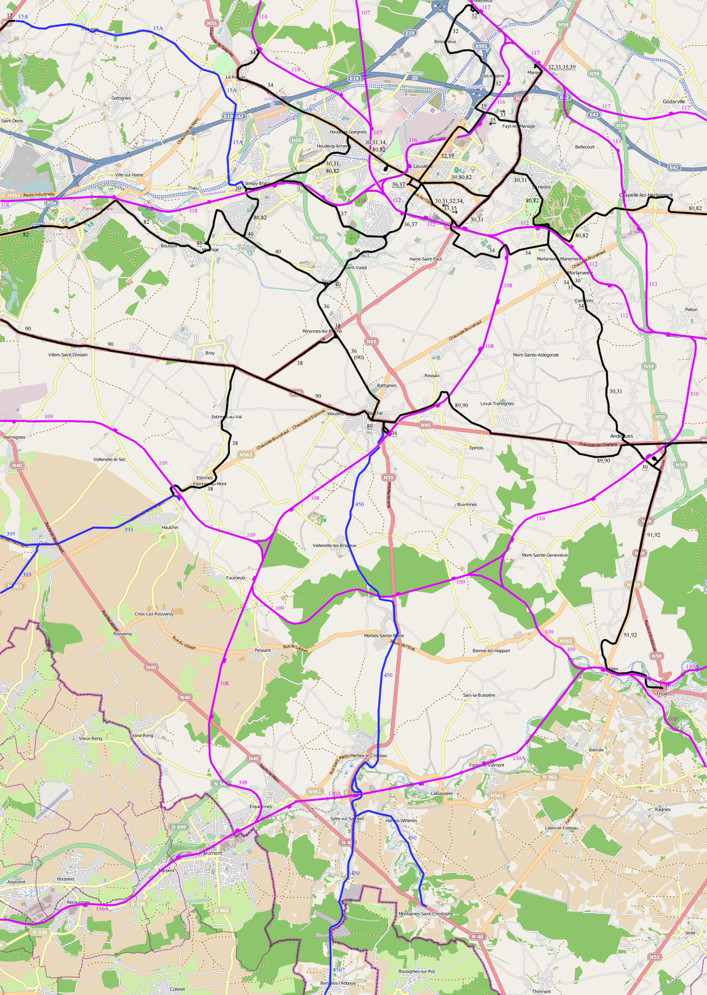
English: Map showing the vicinal tram routes in the Hainaut Centre area at the maximum extent. Not all lines where open at the same time and some routes were changed. The electric lines are as in 1947. This is with a openstreetmap background.
The black lines are electric, the blue lines non-electric lines and the red lines railways.
Nederlands: Kaart die de maximale uitbreiding van het tramnet in de Henegouwen Centre streek toont. Niet alle routes zijn gelijktijdig open en sommige routes zijn gewijzigd. De achtergrond is een openstreetmap.
De zwarte lijnen zijn elektrisch, de blauwe niet-elektrisch en de rode spoorwegen. |
| Date | |
| Source | Travail personnel |
| Auteur | Smiley.toerist |
| Autorisation (Réutilisation de ce fichier) |
All OpenStreetMap data and maps are Creative Commons "CC-BY-SA 2.0" licensed |
| Autres versions | original import: File:Hainaut Centre.png, without openstreet background: File:Hainaut centre SNCV names.png |
Conditions d’utilisation
Moi, en tant que détenteur des droits d’auteur sur cette œuvre, je la publie sous les licences suivantes :

|
Vous avez la permission de copier, distribuer et modifier ce document selon les termes de la GNU Free Documentation License version 1.2 ou toute version ultérieure publiée par la Free Software Foundation, sans sections inaltérables, sans texte de première page de couverture et sans texte de dernière page de couverture. Un exemplaire de la licence est inclus dans la section intitulée GNU Free Documentation License. |
Ce fichier est sous licence Creative Commons Attribution – Partage dans les Mêmes Conditions 3.0 (non transposée), 2.5 Générique, 2.0 Générique et 1.0 Générique.
- Vous êtes libre :
- de partager – de copier, distribuer et transmettre cette œuvre
- d’adapter – de modifier cette œuvre
- Sous les conditions suivantes :
- paternité – Vous devez donner les informations appropriées concernant l'auteur, fournir un lien vers la licence et indiquer si des modifications ont été faites. Vous pouvez faire cela par tout moyen raisonnable, mais en aucune façon suggérant que l’auteur vous soutient ou approuve l’utilisation que vous en faites.
- partage à l’identique – Si vous modifiez, transformez, ou vous basez sur cette œuvre, vous devez distribuer votre contribution sous la même licence ou une licence compatible avec celle de l’original.
Vous pouvez choisir l’une de ces licences.
Historique du fichier
Cliquer sur une date et heure pour voir le fichier tel qu'il était à ce moment-là.
| Date et heure | Vignette | Dimensions | Utilisateur | Commentaire | |
|---|---|---|---|---|---|
| actuel | 15 août 2011 à 15:09 | | 1 456 × 2 050 (2,71 Mio) | Smiley.toerist | Connection line 80 and 82 added + route in Gougnies changed |
| 11 août 2011 à 16:25 |  | 1 456 × 2 050 (2,7 Mio) | Smiley.toerist | {{Information |Description ={{en|1=Map showing the vicinal tram routes in the Hainaut Centre area at the maximum extent. Not all lines where open at the same time and some routes were changed. The electric lines are as in 1947. This is with a openstree |
Utilisation du fichier
Les 11 pages suivantes utilisent ce fichier :
- Ligne de tramway 30 (SNCV Groupe du Centre)
- Ligne de tramway 32 (SNCV Groupe du Centre)
- Ligne de tramway 33/35
- Ligne de tramway 34 (SNCV Groupe du Centre)
- Ligne de tramway 36A
- Ligne de tramway 36 (SNCV Groupe du Centre)
- Ligne de tramway 37 (SNCV Groupe du Centre)
- Ligne de tramway 38 (SNCV Groupe du Centre)
- Ligne de tramway 39 (SNCV Groupe du Centre)
- Ligne de tramway 40 (SNCV Groupe du Centre)
- Lignes de tramway de la SNCV dans la province de Hainaut