
Fichier:FortHarmar.jpg

Fichier d’origine (837 × 489 pixels, taille du fichier : 114 kio, type MIME : image/jpeg)
Ce fichier et sa description proviennent de Wikimedia Commons.
Description
| Description |
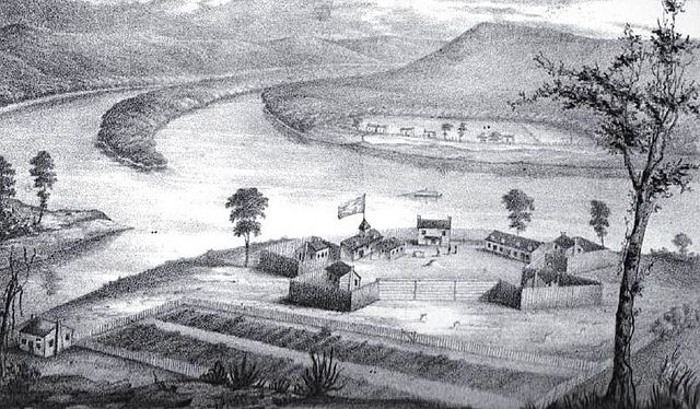
English: Fort Harmar, constructed in the autumn of 1785 at the confluence of the Ohio and Muskingum rivers, on the west side of the mouth of the Muskingum River. “The position was judiciously chosen, as it commanded not only the mouth of the Muskingum, but swept the waters of the Ohio, from a curve in the river for a considerable distance both above and below the fort.” The view of the image is looking forward towards the Ohio, with the mouth of the Muskingum on the left; in the background, across the Ohio River, are houses of the settlement that would later become Williamstown. Buckley Island is located to the upper left in the Ohio River.
The Campus Martius fortification of the Marietta settlement was built on the east side of the Muskingum and upriver from Fort Harmar during 1788, and fully completed in 1791 at the start of the Northwest Indian War. The Picketed Point fortification of Marietta was built directly across the Muskingum from Fort Harmar, on the east side of the mouth, during 1791. Image and quote from the book by S. P. Hildreth: Pioneer History: Being an Account of the First Examinations of the Ohio Valley, and the Early Settlement of the Northwest Territory, H. W. Derby and Co., Cincinnati, Ohio (1848). Illustration plate located between pp. 316-17.
|
| Date | avant 1806 |
| Source | Hildreth, S. P. (1848) Pioneer History: Being an Account of the First Examinations of the Ohio Valley, and the Early Settlement of the Northwest Territory, Cincinnati : H. W. Derby and Co, p. 316 1/2 |
| Auteur | Judge Joseph Gilman (1738-1806) |
Conditions d’utilisation
Ce document est dans le domaine public aux États-Unis. Ceci s'applique aux travaux des États-Unis où le copyright a expiré, souvent parce que sa première publication s'est produite avant le 1er janvier 1929. Voir cette page pour davantage d'explication.
|
 | |
 |
Cette image peut ne pas être dans le domaine public en dehors des États-Unis (ceci s'applique particulièrement au Canada, en Chine (pas Hong Kong, Macao, ni Taïwan), en Allemagne ou en Suisse). Le créateur et l'année de la publication sont l'information essentielle et doivent être fournis.
|
Journal des téléversements d’origine
- 2011-06-29 22:49 ColWilliam 837×489× (116770 bytes) adjust brightness and contrast ~~~~
- 2008-04-11 20:50 ColWilliam 831×493× (75613 bytes) Fort Harmar, constructed in the autumn of 1785 at the confluence of the Ohio and Muskingum rivers, on the west side of the mouth of the Muskingum River. From the book by S. P. Hildreth: ''Pioneer History: Being an Account of the First Examinations of the
| Annotations | Cette image est annotée : Voir les annotations sur Wikimedia Commons |
Historique du fichier
Cliquer sur une date et heure pour voir le fichier tel qu'il était à ce moment-là.
| Date et heure | Vignette | Dimensions | Utilisateur | Commentaire | |
|---|---|---|---|---|---|
| actuel | 28 juin 2014 à 03:12 | | 837 × 489 (114 kio) | OgreBot | (BOT): Reverting to most recent version before archival |
| 28 juin 2014 à 03:12 |  | 831 × 493 (74 kio) | OgreBot | (BOT): Uploading old version of file from en.wikipedia; originally uploaded on 2008-04-11 20:50:13 by ColWilliam | |
| 27 juin 2014 à 17:24 |  | 837 × 489 (114 kio) | Jalo | Transferred from en.wikipedia |
Utilisation du fichier
La page suivante utilise ce fichier :
Usage global du fichier
Les autres wikis suivants utilisent ce fichier :
- Utilisation sur arz.wikipedia.org
- Utilisation sur en.wikipedia.org
- Utilisation sur it.wikipedia.org
- Utilisation sur www.wikidata.org