
Fichier:Flight path of the Libyan MiG-23 crashed on the Sila Mountains.svg

Taille de cet aperçu PNG pour ce fichier SVG : 429 × 599 pixels. Autres résolutions : 172 × 240 pixels | 343 × 480 pixels | 549 × 768 pixels | 733 × 1 024 pixels | 1 465 × 2 048 pixels | 458 × 640 pixels.
Fichier d’origine (Fichier SVG, nominalement de 458 × 640 pixels, taille : 1,05 Mio)
Ce fichier et sa description proviennent de Wikimedia Commons.
Description
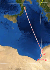
| Description | possible flight path of the Libyan MiG-23 crashed on the Sila Mountains, based on Italian Air Force technical investigations. |
| Date | |
| Source | |
| Auteur | Eric Gaba (Sting - fr:Sting), F l a n k e r |
Conditions d’utilisation
Ce fichier est disponible selon les termes de la licence Creative Commons Attribution – Partage dans les Mêmes Conditions 3.0 (non transposée).
- Vous êtes libre :
- de partager – de copier, distribuer et transmettre cette œuvre
- d’adapter – de modifier cette œuvre
- Sous les conditions suivantes :
- paternité – Vous devez donner les informations appropriées concernant l'auteur, fournir un lien vers la licence et indiquer si des modifications ont été faites. Vous pouvez faire cela par tout moyen raisonnable, mais en aucune façon suggérant que l’auteur vous soutient ou approuve l’utilisation que vous en faites.
- partage à l’identique – Si vous modifiez, transformez, ou vous basez sur cette œuvre, vous devez distribuer votre contribution sous la même licence ou une licence compatible avec celle de l’original.
Historique du fichier
Cliquer sur une date et heure pour voir le fichier tel qu'il était à ce moment-là.
| Date et heure | Vignette | Dimensions | Utilisateur | Commentaire | |
|---|---|---|---|---|---|
| actuel | 27 novembre 2012 à 16:43 | | 458 × 640 (1,05 Mio) | F l a n k e r | clean up and letters for waypoints |
| 27 novembre 2012 à 16:35 |  | 458 × 640 (1,04 Mio) | F l a n k e r | {{Information |Description=possible flight path of the Libyan MiG-23 crashed on the Sila Mountains, based on Italian Air Force technical investigations. |Source= *File:Mediterranean Sea political map-blank.svg *http://www.stragi80.it/documenti/mig... |
Utilisation du fichier
La page suivante utilise ce fichier :
Usage global du fichier
Les autres wikis suivants utilisent ce fichier :
- Utilisation sur it.wikipedia.org