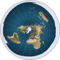
Fichier:Flat earth.png
Flat_earth.png (543 × 543 pixels, taille du fichier : 396 kio, type MIME : image/png)
Historique du fichier
Cliquer sur une date et heure pour voir le fichier tel qu'il était à ce moment-là.
| Date et heure | Vignette | Dimensions | Utilisateur | Commentaire | |
|---|---|---|---|---|---|
| actuel | 25 août 2012 à 03:33 |  | 543 × 543 (396 kio) | AnonMoos | Reverted to version as of 17:17, 12 December 2008 |
| 25 août 2012 à 01:30 |  | 543 × 543 (402 kio) | Rotatebot | Bot: Image rotated by 180° | |
| 12 décembre 2008 à 19:17 |  | 543 × 543 (396 kio) | MathiasRav | {{Information |Description={{en|I made this map myself by creating an azimuthal projection of the entire Earth. A rendered picture of the Flat Earth model. The white around the outside of the globe is an 'Ice Wall', preventing people from falling off the |
Utilisation du fichier
La page suivante utilise ce fichier :
Usage global du fichier
Les autres wikis suivants utilisent ce fichier :
- Utilisation sur ar.wikipedia.org
- Utilisation sur ce.wikipedia.org
- Utilisation sur cs.wikipedia.org
- Utilisation sur cv.wikipedia.org
- Utilisation sur de.wikipedia.org
- Utilisation sur de.wikivoyage.org
- Utilisation sur eml.wikipedia.org
- Utilisation sur en.wikipedia.org
- Utilisation sur et.wikipedia.org
- Utilisation sur eu.wikipedia.org
- Utilisation sur fa.wikipedia.org
- Utilisation sur he.wikipedia.org
- Utilisation sur hy.wikipedia.org
- Utilisation sur inh.wikipedia.org
- Utilisation sur ja.wikipedia.org
- Utilisation sur jv.wikipedia.org
- Utilisation sur ko.wikipedia.org
- Utilisation sur ms.wikipedia.org
- Utilisation sur nl.wikipedia.org
- Utilisation sur pl.wikipedia.org
- Utilisation sur pt.wikipedia.org
- Utilisation sur ru.wikipedia.org
- Utilisation sur uk.wikipedia.org
- Utilisation sur zh.wikipedia.org

