
Fichier:Fertiliser, Farming and Ferry - geograph.org.uk - 1737437.jpg

Taille de cet aperçu : 800 × 591 pixels. Autres résolutions : 320 × 236 pixels | 640 × 473 pixels | 1 024 × 756 pixels | 1 280 × 945 pixels | 2 560 × 1 891 pixels | 3 282 × 2 424 pixels.
Fichier d’origine (3 282 × 2 424 pixels, taille du fichier : 1,68 Mio, type MIME : image/jpeg)
Ce fichier et sa description proviennent de Wikimedia Commons.
Description
| Description |
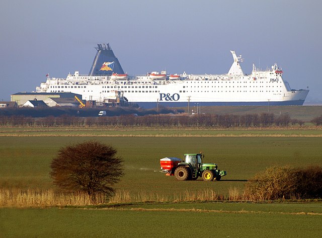
English: Fertiliser, Farming and Ferry, Paull, East Riding of Yorkshire, England. A farmer distributes fertiliser from the back of his John Deere tractor on farmland north of Newton Garth near to the Hedon to Paull road early in the morning. At the same time, North Sea Ferry Pride of York passes on the River Humber just before it berths up outside of King George Dock in Hull. Towards the stern of the boat can be seen Paull Shipyard where a sea-going tug is being built – it is dwarfed by the ferry behind it! The embankment on the side of the Humber hides the river itself, so the ferry looks like a field object in its own right! As a telephoto lens was used for the photograph, the tractor seems to be close to the ferry, but the latter in reality, is well over a mile behind it! The photo was taken from Hedon Flyover |
| Date | |
| Source | From geograph.org.uk |
| Auteur | Andy Beecroft |
| Autorisation (Réutilisation de ce fichier) |
Creative Commons Attribution Share-alike license 2.0 |
| Attribution (imposé par la licence) | Andy Beecroft / Fertiliser, Farming and Ferry / |
| Lieu de la prise de vue | | Voir cet endroit et d’autres images sur : OpenStreetMap |
|---|
Conditions d’utilisation

|
Cette image provient de la collection du projet Geograph British Isles. Pour obtenir les coordonnées du photographe, veuillez consulter cette page de description de l'image sur le site du projet. Les droits d'auteurs sur cette image sont détenus par Andy Beecroft ; l'image est placée sous une licence Creative Commons avec mention de paternité et partage à l'identique (CC-By-SA) en version 2.0.
|
Ce fichier est disponible selon les termes de la licence Creative Commons Attribution – Partage dans les Mêmes Conditions 2.0 Générique
Attribution: Andy Beecroft
- Vous êtes libre :
- de partager – de copier, distribuer et transmettre cette œuvre
- d’adapter – de modifier cette œuvre
- Sous les conditions suivantes :
- paternité – Vous devez donner les informations appropriées concernant l'auteur, fournir un lien vers la licence et indiquer si des modifications ont été faites. Vous pouvez faire cela par tout moyen raisonnable, mais en aucune façon suggérant que l’auteur vous soutient ou approuve l’utilisation que vous en faites.
- partage à l’identique – Si vous modifiez, transformez, ou vous basez sur cette œuvre, vous devez distribuer votre contribution sous la même licence ou une licence compatible avec celle de l’original.
Historique du fichier
Cliquer sur une date et heure pour voir le fichier tel qu'il était à ce moment-là.
| Date et heure | Vignette | Dimensions | Utilisateur | Commentaire | |
|---|---|---|---|---|---|
| actuel | 13 juin 2010 à 02:21 | | 3 282 × 2 424 (1,68 Mio) | File Upload Bot (Magnus Manske) | == {{int:filedesc}} == {{Information |Description={{en|1=Fertiliser, Farming and Ferry, near to Hedon, East Riding of Yorkshire, Great Britain. A farmer distributes fertiliser from the back of his tractor on farmland north of Newton Garth near to the Hedo |
Utilisation du fichier
Les 2 pages suivantes utilisent ce fichier :
Usage global du fichier
Les autres wikis suivants utilisent ce fichier :
- Utilisation sur en.wikipedia.org
- Utilisation sur it.wikipedia.org
- Utilisation sur no.wikipedia.org
- Utilisation sur www.wikidata.org