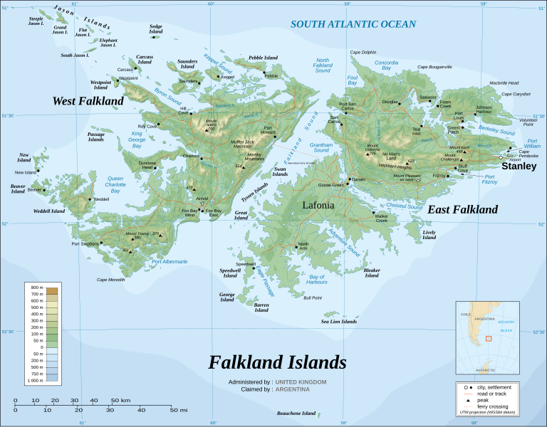
Fichier:Falkland Islands topographic map-en.svg
Apparence

Taille de cet aperçu PNG pour ce fichier SVG : 768 × 599 pixels. Autres résolutions : 308 × 240 pixels | 615 × 480 pixels | 984 × 768 pixels | 1 280 × 999 pixels | 2 560 × 1 998 pixels | 2 550 × 1 990 pixels.
Fichier d’origine (Fichier SVG, nominalement de 2 550 × 1 990 pixels, taille : 1,97 Mio)
Historique du fichier
Cliquer sur une date et heure pour voir le fichier tel qu'il était à ce moment-là.
| Date et heure | Vignette | Dimensions | Utilisateur | Commentaire | |
|---|---|---|---|---|---|
| actuel | 23 août 2021 à 03:51 |  | 2 550 × 1 990 (1,97 Mio) | Praça de Maio | File uploaded using svgtranslate tool (https://svgtranslate.toolforge.org/). Added translation for tr. |
| 23 août 2021 à 03:50 |  | 2 550 × 1 990 (1,97 Mio) | Praça de Maio | File uploaded using svgtranslate tool (https://svgtranslate.toolforge.org/). Added translation for tr. | |
| 6 avril 2017 à 12:54 |  | 2 550 × 1 990 (1,91 Mio) | RaviC | + New Haven Ferry | |
| 19 décembre 2008 à 19:38 |  | 2 550 × 1 990 (1,93 Mio) | Sting | Reverted to version as of 03:38, 14 November 2007: please upload the translated version under a specific name | |
| 19 décembre 2008 à 19:26 |  | 2 550 × 1 990 (1,93 Mio) | Vitek | this is just croatian translation | |
| 14 novembre 2007 à 04:38 |  | 2 550 × 1 990 (1,93 Mio) | Sting | New version more accurate and with shaded relief | |
| 16 juin 2007 à 02:18 |  | 2 550 × 1 990 (1,03 Mio) | Sting | Reverted to earlier revision | |
| 16 juin 2007 à 02:03 |  | 2 550 × 1 990 (2,14 Mio) | Sting | Trying to fix the bug on WP-en #8 | |
| 16 juin 2007 à 01:40 |  | 2 550 × 1 990 (2,01 Mio) | Sting | Trying to fix the bug on WP-en #7 (really boring...) | |
| 16 juin 2007 à 01:29 |  | 2 550 × 1 990 (2,08 Mio) | Sting | Trying to fix the bug on WP-en #6 (OK, the problem comes from the shaded relief raster image) |
Utilisation du fichier
Les 4 pages suivantes utilisent ce fichier :
Usage global du fichier
Les autres wikis suivants utilisent ce fichier :
- Utilisation sur af.wikipedia.org
- Utilisation sur ar.wikipedia.org
- Utilisation sur ast.wikipedia.org
- Utilisation sur azb.wikipedia.org
- Utilisation sur bcl.wikipedia.org
- Utilisation sur bg.wikipedia.org
- Utilisation sur bn.wikipedia.org
- Utilisation sur ca.wikipedia.org
- Utilisation sur ckb.wikipedia.org
- Utilisation sur crh.wikipedia.org
- Utilisation sur cs.wikipedia.org
- Utilisation sur cv.wikipedia.org
- Utilisation sur de.wikipedia.org
- Utilisation sur en.wikipedia.org
- Geography of the Falkland Islands
- Irredentism
- West Falkland
- Lafonia
- List of settlements in the Falkland Islands
- Category talk:Geography
- List of Scottish place names in other countries
- Falkland Islands sovereignty dispute
- Wikipedia:WikiProject Argentina
- Geology of the Falkland Islands
- Portal:Geography/Featured picture archive
- Wikipedia:Featured pictures thumbs/06
- Portal:Maps/Selected picture
- Falkland Islands
- List of Falkland Islands placenames
- Port Albemarle
- King George Bay
- Byron Sound
- MacBride Head
- Keppel Sound
- History of the Special Air Service
- Wikipedia:Featured picture candidates/Falkland Islands topographic map-en.svg
- List of rivers of the Falkland Islands
- Port William, Falkland Islands
- Bay of Harbours
- Adventure Sound
- Queen Charlotte Bay
- Foul Bay, Falkland Islands
- Concordia Bay
- Eagle Passage
Voir davantage sur l’utilisation globale de ce fichier.


