
Fichier:Erebus 360 L257atc-B652R1.jpg

Taille de cet aperçu : 800 × 211 pixels. Autres résolutions : 320 × 84 pixels | 640 × 168 pixels | 1 024 × 270 pixels | 1 280 × 337 pixels | 2 560 × 674 pixels | 22 780 × 5 996 pixels.
Fichier d’origine (22 780 × 5 996 pixels, taille du fichier : 74,36 Mio, type MIME : image/jpeg)
Ce fichier et sa description proviennent de Wikimedia Commons.
| Avertissement | Certains navigateurs peuvent avoir des difficultés à afficher cette image à sa résolution complète : elle possède un nombre de pixels singulièrement élevé et peut ne pas se charger correctement ou faire planter votre navigateur. |
|---|
Description
| Description |
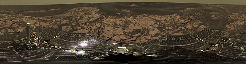
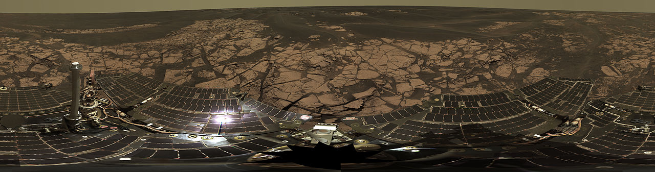
English: This is the Opportunity panoramic camera's "Erebus Rim" panorama, acquired on sols 652 to 663 (Nov. 23 to Dec. 5, 2005 ), as NASA's Mars Exploration Rover Opportunity was exploring sand dunes and outcrop rocks in Meridiani Planum. The panorama originally consisted of 635 separate images in four different Pancam filters, and covers 360 degrees of terrain around the rover and the full rover deck. Since the time that this panorama was acquired, and while engineers have been diagnosing and testing Opportunity's robotic arm, the panorama has been expanded to include more than 1,300 images of this terrain through all of the Pancam multispectral filters. It is the largest panorama acquired by either rover during the mission.
The panorama shown here is an approximate true-color rendering using Pancam's 750 nanometer, 530 nanometer and 430 nanometer filters. It is presented here as a cylindrical projection. Image-to-image seams have been eliminated from the sky portion of the mosaic to better simulate the vista a person standing on Mars would see. This panorama provides the team's highest resolution view yet of the finely-layered outcrop rocks, wind ripples, and small cobbles and grains along the rim of the wide but shallow "Erebus" crater. Once the arm diagnostics and testing are completed, the team hopes to explore other layered outcrop rocks at Erebus and then eventually continue southward toward the large crater known as "Victoria." |
| Date | entre le 23 novembre 2005 et le 5 décembre 2005 |
| Source | http://marsrovers.jpl.nasa.gov/gallery/press/opportunity/20060104a.html / http://photojournal.jpl.nasa.gov/catalog/PIA03270 |
| Auteur | NASA/JPL-Caltech/Cornell |
| 360° | Voir cette photo dans un panorama virtuel.
|
|---|
Cette image ou vidéo a été cataloguée par le Jet Propulsion Lab de la National Aeronautics and Space Administration (NASA) des États-Unis sous Photo ID : PIA03270.Ce bandeau n’indique rien sur le statut de l’œuvre au regard du droit d'auteur. Un bandeau de droit d’auteur est requis. Voir Commons:À propos des licences pour plus d’informations. Autres langues :
|
Conditions d’utilisation
| Ce fichier provient de la NASA. Sauf exception, les documents créés par la NASA ne sont pas soumis à copyright. Pour plus d'informations, voir la politique de copyright de la NASA. | ||
 |
Attention :
|
Historique du fichier
Cliquer sur une date et heure pour voir le fichier tel qu'il était à ce moment-là.
| Date et heure | Vignette | Dimensions | Utilisateur | Commentaire | |
|---|---|---|---|---|---|
| actuel | 22 février 2013 à 08:00 | 22 780 × 5 996 (74,36 Mio) | Huntster | Original super-resolution version of image. | |
| 15 janvier 2006 à 12:50 | 3 000 × 790 (523 kio) | JamesHoadley | w:Erebus crater. From [http://marsrovers.jpl.nasa.gov/gallery/press/opportunity/20060104a.html]. Original caption: <blockquote>'''On the Rim of 'Erebus'''' This is the Opportunity panoramic camera's "Erebus Rim" panorama, acquired on sols 652 to 66 |
Utilisation du fichier
La page suivante utilise ce fichier :
Usage global du fichier
Les autres wikis suivants utilisent ce fichier :
- Utilisation sur ast.wikipedia.org
- Utilisation sur bs.wikipedia.org
- Utilisation sur de.wikipedia.org
- Utilisation sur en.wikipedia.org
- Utilisation sur es.wikipedia.org
- Utilisation sur hi.wikipedia.org
- Utilisation sur it.wikipedia.org
- Utilisation sur ja.wikipedia.org
- Utilisation sur ko.wikipedia.org
- Utilisation sur lb.wikipedia.org
- Utilisation sur mn.wikipedia.org
- Utilisation sur pt.wikipedia.org
- Utilisation sur ro.wikipedia.org
- Utilisation sur ru.wikipedia.org
- Utilisation sur uk.wikipedia.org
- Utilisation sur zh.wikipedia.org