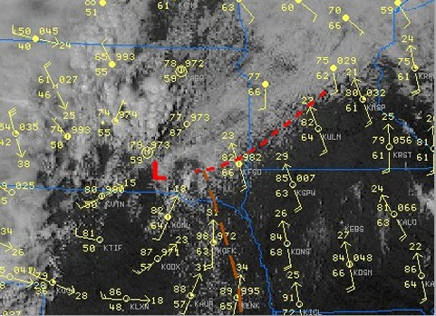
Fichier:Dry line-Satellite view.jpg

Le contenu de la page n’est pas pris en charge dans d’autres langues.
Une page de Wikipédia, l'encyclopédie libre.

Dry_line-Satellite_view.jpg(481 × 348 pixels, taille du fichier : 103 kio, type MIME : image/jpeg)

Ce fichier et sa description proviennent de Wikimedia Commons.

Description Satellite view in visible range of convection along a Dry line (yellow line) and surface station data showing temperature around 86F in the whole sector but dew points in the 60's east of it and in the 50' West of it.
Date
Source National Weather Service (NOAA) in a case Study of the Southeast South Dakota Tornadoes of 16 September 2006
Auteur Pierre cb
Autorisation
(Réutilisation de ce fichier)
Public domain
Cette image est dans le domaine public car son contenu provient de la
National Oceanic and Atmospheric Administration
, réalisé par un employé dans le cadre de ses activités professionnelles.

العربية  čeština  Deutsch  Zazaki  English  español  eesti  suomi  français  hrvatski  magyar  italiano  日本語  한국어  македонски  മലയാളം  Plattdüütsch  Nederlands  polski  português  română  русский  sicilianu  slovenščina  Türkçe  Tiếng Việt  简体中文  繁體中文  +/−

Légendes

Ajoutez en une ligne la description de ce que représente ce fichier

Éléments décrits dans ce fichier

dépeint

Historique du fichier

Cliquer sur une date et heure pour voir le fichier tel qu'il était à ce moment-là.

Date et heureVignetteDimensionsUtilisateurCommentaire
actuel27 juin 2016 à 15:30Vignette pour la version du 27 juin 2016 à 15:30481 × 348 (103 kio)Pierre cbCropped version
19 octobre 2007 à 01:52Vignette pour la version du 19 octobre 2007 à 01:52500 × 493 (152 kio)Pierre cb{{Information |Description=Satellite view in visible range of convection along a Dry line (yellow line) and surface station data showing temperature around 86F in the whole sector but dew points in the 60's east of it and in the 50' West of it. |Source=[h

La page suivante utilise ce fichier :

Usage global du fichier

Les autres wikis suivants utilisent ce fichier :

Métadonnées