
Fichier:DjoudjNASA.jpg
Pas de plus haute résolution disponible.
DjoudjNASA.jpg (560 × 305 pixels, taille du fichier : 79 kio, type MIME : image/jpeg)
Ce fichier et sa description proviennent de Wikimedia Commons.
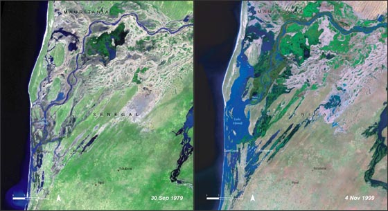
| Description | Lake Djoudj during the Sept. 1979 drought (left) and during the Nov. 1999 flood (right). http://landsat.gsfc.nasa.gov/images/archive/f0011.html In August 2006, the United Nations Environment Programme (UNEP), released an atlas entitled: "Africa's Lakes: Atlas of Our Changing Environment." The atlas relies heavily on Landsat imagery from the past 34 years to show changes in lakes around the African continent. Above, are two Landsat images of the Djoudj Sanctuary in Senegal that are featured in the atlas. The atlas tell us: "Situated in the Senegal river delta, the Djoudj Sanctuary is a wetland of 16 000 ha, comprising a large lake, referred to as Lake Djoudj in this publication, surrounded by streams, ponds and backwaters. These two images show the Djoudj Sanctuary before and after the construction of the Diama Dam." "The image from September 1979 shows the impact of drought on the Djoudj Sanctuary, while the image from November 1999 shows rejuvenation of the sanctuary wetlands due to the significant floods of that year. The two images vividly depict the impact of climate variability on the Djoudj Sanctuary—and demonstrate the broader need for close monitoring of the impacts of climate variability and climate change on lake environments." |
| Date | August 2006 September 1979 November 1999 (5 octobre 2006 (d'après les données Exif)) |
| Source | NASA [1] |
| Auteur | Auteur inconnu |
| Ce fichier provient de la NASA. Sauf exception, les documents créés par la NASA ne sont pas soumis à copyright. Pour plus d'informations, voir la politique de copyright de la NASA. | ||
 |
Attention :
|
Historique du fichier
Cliquer sur une date et heure pour voir le fichier tel qu'il était à ce moment-là.
| Date et heure | Vignette | Dimensions | Utilisateur | Commentaire | |
|---|---|---|---|---|---|
| actuel | 16 août 2007 à 22:03 | | 560 × 305 (79 kio) | Ji-Elle | Lake Djoudj during the Sept. 1979 drought (left) and during the Nov. 1999 flood (right). http://landsat.gsfc.nasa.gov/images/archive/f0011.html In August 2006, the United Nations Environment Programme (UNEP), released an atlas entitled: "Africa's Lakes: |
Utilisation du fichier
La page suivante utilise ce fichier :
Usage global du fichier
Les autres wikis suivants utilisent ce fichier :
- Utilisation sur ar.wikipedia.org
- Utilisation sur az.wikipedia.org
- Utilisation sur ca.wikipedia.org
- Utilisation sur en.wikipedia.org
- Utilisation sur en.wikinews.org
- Utilisation sur hy.wikipedia.org
- Utilisation sur mt.wikipedia.org
- Utilisation sur ru.wikipedia.org
- Utilisation sur ru.wikinews.org
- Utilisation sur www.wikidata.org