
Fichier:Dione PIA08413.jpg

Fichier d’origine (6 204 × 3 522 pixels, taille du fichier : 2,97 Mio, type MIME : image/jpeg)
Ce fichier et sa description proviennent de Wikimedia Commons.
Description
| Description |
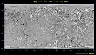
English: This global map of Saturn's moon Dione was created using images taken during Cassini spacecraft flybys, with Voyager images filling in the gaps in Cassini's coverage.
An extensive system of bright ice cliffs created by tectonic fractures adorns the moon's trailing hemisphere. The map is a simple cylindrical (equidistant) projection and has a scale of 614 meters (2,014 feet) per pixel at the equator. The mean radius of Dione used for projection of this map is 562 kilometers (349 miles). This updated map has been shifted west by 0.6 degrees of longitude, compared to the previously released Cassini product (PIA08341), in order to conform to the International Astronomical Union longitude system convention for Dione. The Cassini-Huygens mission is a cooperative project of NASA, the European Space Agency and the Italian Space Agency. The Jet Propulsion Laboratory, a division of the California Institute of Technology in Pasadena, manages the mission for NASA's Science Mission Directorate, Washington, D.C. The Cassini orbiter and its two onboard cameras were designed, developed and assembled at JPL. The imaging operations center is based at the Space Science Institute in Boulder, Colo. |
| Date | |
| Source | http://photojournal.jpl.nasa.gov/catalog/PIA08413 |
| Auteur | NASA/JPL/Space Science Institute |
| Autres versions | Œuvres dérivées de ce fichier : Dione PIA08413 moon only.JPG |
Conditions d’utilisation
| Ce fichier provient de la NASA. Sauf exception, les documents créés par la NASA ne sont pas soumis à copyright. Pour plus d'informations, voir la politique de copyright de la NASA. | ||
 |
Attention :
|
Historique du fichier
Cliquer sur une date et heure pour voir le fichier tel qu'il était à ce moment-là.
| Date et heure | Vignette | Dimensions | Utilisateur | Commentaire | |
|---|---|---|---|---|---|
| actuel | 21 mai 2008 à 00:48 | | 6 204 × 3 522 (2,97 Mio) | Bryan Derksen | {{Information |Description={{en|This global map of Saturn's moon Dione was created using images taken during Cassini spacecraft flybys, with Voyager images filling in the gaps in Cassini's coverage. An extensive system of bright ice cliffs created by tec |
Utilisation du fichier
Aucune page n’utilise ce fichier.
Usage global du fichier
Les autres wikis suivants utilisent ce fichier :
- Utilisation sur ca.wikipedia.org
- Utilisation sur eo.wikipedia.org
- Utilisation sur lv.wikipedia.org
- Utilisation sur pl.wikipedia.org