
Fichier:Confederate States map 1861-12-31 to 1865-05-05 (cropped).png

Fichier d’origine (2 000 × 1 007 pixels, taille du fichier : 314 kio, type MIME : image/png)
Ce fichier et sa description proviennent de Wikimedia Commons.
.png?uselang=fr)
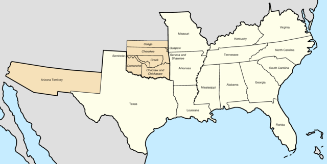
The map shows Kentucky as a Confederate state during the Civil War. More accurately KY was neutral with strong leanings toward the Union position.
This map needs a footnote, the border states of Kentucky and Missouri did not secede from the Union and West Virginia, formerly part of Virginia, achieved statehood in 1863 and joined the Union. Maps depicting that can be found here: https://education.nationalgeographic.org/resource/union-confederacy and here: https://cdn.britannica.com/36/64936-050-CA32EEFC/states-Confederate-States-of-America-fall-members-1863.jpg
Description
| Description |
English: Map of the Confederate States — the 11 states, the two state governments in exile, the one territory, and the 8 allied tribes |
| Date | |
| Source |
Ce fichier est dérivé de : Confederate States map 1861-12-31 to 1865-05-05.png de original author |
| Auteur |
Golbez Vecteur : |
| Autorisation (Réutilisation de ce fichier) |
Ce fichier est sous la licence Creative Commons Attribution – Partage dans les Mêmes Conditions 4.0 International.
|
Historique du fichier
Cliquer sur une date et heure pour voir le fichier tel qu'il était à ce moment-là.
| Date et heure | Vignette | Dimensions | Utilisateur | Commentaire | |
|---|---|---|---|---|---|
| actuel | 25 août 2020 à 12:59 | | 2 000 × 1 007 (314 kio) | Lieutcoluseng | Uploaded a work by {{AutVec|o={{Creator|Golbez|option=collapse}}|Lieutcoluseng|width=125}} from {{ Derived from|Confederate States map 1861-12-31 to 1865-05-05.png| by = {{u|Golbez|'''original''' author}} }} with UploadWizard |
Utilisation du fichier
La page suivante utilise ce fichier :
Usage global du fichier
Les autres wikis suivants utilisent ce fichier :
- Utilisation sur en.wikipedia.org
- Trans-Mississippi Department
- Florida in the American Civil War
- Alabama in the American Civil War
- Mississippi in the American Civil War
- South Carolina in the American Civil War
- Tennessee in the American Civil War
- Texas in the American Civil War
- Georgia in the American Civil War
- North Carolina in the American Civil War
- Virginia in the American Civil War
- Arkansas in the American Civil War
- Louisiana in the American Civil War
- Indian Territory in the American Civil War
- Template:Infobox Confederate State ACW
- Template:Infobox Confederate State ACW/doc
- User:Lucas Duke/Georgia (ACW)
- Template:Infobox Confederate State ACW/sandbox
- List of Confederate states by date of admission to the Confederacy
- Utilisation sur en.wiktionary.org
- Utilisation sur es.wikipedia.org
.png)