
Fichier:Columbiarivermapsnakeriverhighlighted.png
Taille de cet aperçu : 600 × 600 pixels. Autres résolutions : 240 × 240 pixels | 480 × 480 pixels | 768 × 768 pixels | 1 024 × 1 024 pixels | 1 500 × 1 500 pixels.
Fichier d’origine (1 500 × 1 500 pixels, taille du fichier : 3,43 Mio, type MIME : image/png)
Ce fichier et sa description proviennent de Wikimedia Commons.
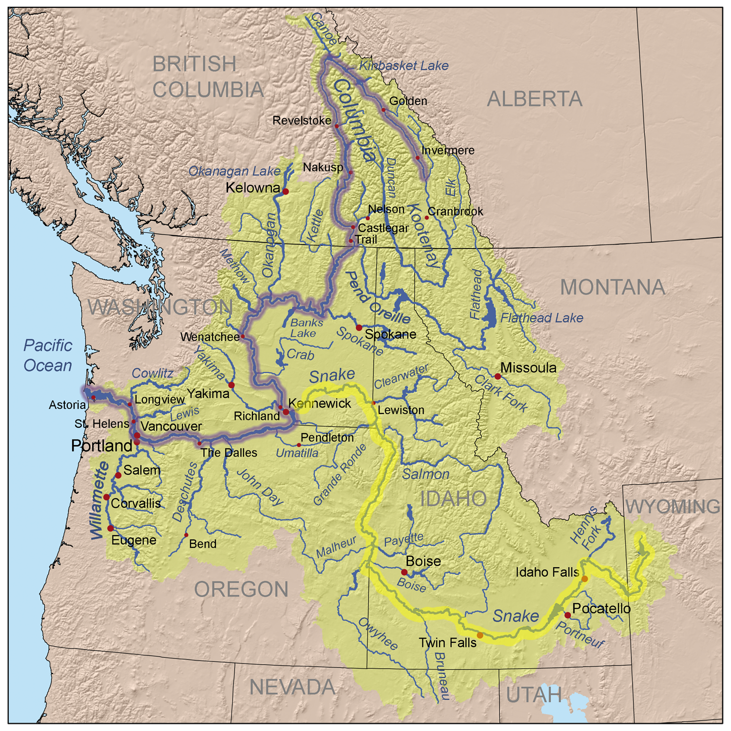
| Description | This is a map of the Columbia River watershed with the Snake River highlighted in yellow and the Columbia River highlighted in blue. |
| Date | (UTC) |
| Source | |
| Auteur |
|
| Cette image a été retouchée, ce qui signifie qu'elle a été modifiée par ordinateur et est différente de l'image d'origine. Liste des modifications : Highlighted the Snake River for use in the Snake River article. L'image d'origine se trouve ici : Columbiarivermap.png:
|
Ce fichier est disponible selon les termes de la licence Creative Commons Attribution – Partage dans les Mêmes Conditions 3.0 (non transposée).
- Vous êtes libre :
- de partager – de copier, distribuer et transmettre cette œuvre
- d’adapter – de modifier cette œuvre
- Sous les conditions suivantes :
- paternité – Vous devez donner les informations appropriées concernant l'auteur, fournir un lien vers la licence et indiquer si des modifications ont été faites. Vous pouvez faire cela par tout moyen raisonnable, mais en aucune façon suggérant que l’auteur vous soutient ou approuve l’utilisation que vous en faites.
- partage à l’identique – Si vous modifiez, transformez, ou vous basez sur cette œuvre, vous devez distribuer votre contribution sous la même licence ou une licence compatible avec celle de l’original.
Journal des téléversements d’origine
This image is a derivative work of the following images:
- File:Columbiarivermap.png licensed with Cc-by-sa-3.0
- 2008-10-14T16:36:55Z Kmusser 1500x1500 (3614755 Bytes) Increased resolution and numerous small additions
- 2008-09-21T01:43:57Z Kmusser 1000x1000 (1640626 Bytes) spelling
- 2008-04-07T19:57:09Z Kmusser 1000x1000 (1585561 Bytes) Added a few more labels.
- 2008-04-07T17:29:20Z Kmusser 1000x1000 (1471006 Bytes) {{Information |Description=This is a map of the [[:en:Columbia River|Columbia River]] watershed with the Columbia River highlighted. |Source=self-made, based on [[:en:USGS|USGS]] and [[:en:Digital Chart of the World|Digital C
Téléversé avec derivativeFX
Historique du fichier
Cliquer sur une date et heure pour voir le fichier tel qu'il était à ce moment-là.
| Date et heure | Vignette | Dimensions | Utilisateur | Commentaire | |
|---|---|---|---|---|---|
| actuel | 9 octobre 2009 à 03:52 | | 1 500 × 1 500 (3,43 Mio) | Shannon1 | {{Information |Description=This is a map of the Columbia River watershed with the Snake River highlighted in yellow and the Columbia River highlighted in blue. |Source=*File:Columbiarivermap.png |Date=2009-10-09 01:47 (UTC) |A |
Utilisation du fichier
Les 4 pages suivantes utilisent ce fichier :
Usage global du fichier
Les autres wikis suivants utilisent ce fichier :
- Utilisation sur da.wikipedia.org
- Utilisation sur de.wikipedia.org
- Utilisation sur en.wikipedia.org
- Utilisation sur es.wikipedia.org
- Utilisation sur fi.wikipedia.org
- Utilisation sur he.wikipedia.org
- Utilisation sur it.wikipedia.org