
Fichier:Colours of Sweden ESA353993.jpg

Fichier d’origine (7 462 × 5 471 pixels, taille du fichier : 91,13 Mio, type MIME : image/jpeg)
Ce fichier et sa description proviennent de Wikimedia Commons.
Description
| Description |
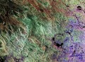
English: This image is a composite of radar scans by Sentinel-1A on different dates of the Siljan Ring, located in the province of Dalarna in central Sweden.
Dalarna, a historical province known for its deep forests, beautiful fishing lakes and lush green landscapes, is a holiday residence for many Swedes and a favourite tourist attraction. Sweden’s sixth largest lake, Siljan covers an area of 290 sq km. Its particular shape comes from the location around the southwestern perimeter of the Siljan Ring, a circular geological formation created almost 400 million years ago by a major meteorite impact. Mainly eroded today, the original crater is estimated to have been some 50 km in diameter. It is the largest known impact crater in Europe and one of the 18 largest known impact craters on Earth. Three scans of the area taken at different dates were overlaid, with different colours assigned to each: red (7 February 2015), green (15 March 2015) and blue (27 March 2015). The colours represent changes on the ground between the various acquisitions. Given the location and the time of year, it is safe to infer that the landscape was dominated by vegetated areas, partly or completely frozen lakes and lots of snow. It is probably also safe to assume that most changes are related to variations in snow cover and snow condition. Focusing on the Siljan Lake, towards the central right part of the image, it is easy to make out the bright red and green lines, which come from changes in the ice edge and cover on the lake, in early spring. Southeast of the lake area, the town of Borlänge is clearly visible along the Dal River, appearing as bright white. Famous for its medieval cathedral of Stora Tuna and its important rail and bus junction, it became a commercial centre for the surrounding agricultural and industrial areas. The town has paper mills, sawmills, engineering works, foundries, printing establishments and factories. The strikingly sharp blue to the east of Borlänge probably represents fresh snow, which fell sometime around the end of March and covered the flat agricultural fields, thus changing the ground properties. Sentinel-1A has been in orbit since 3 April 2014. It is a polar-orbiting, all-weather, day-and-night radar imaging mission for land and ocean services, monitoring the marine environment and mapping water and soil surfaces, among other major applications. This image is also featured on theEarth from Space video Programme. |
| Date | |
| Source | http://www.esa.int/spaceinimages/Images/2016/02/Colours_of_Sweden |
| Auteur | European Space Agency |
| Autorisation (Réutilisation de ce fichier) |
Copernicus Sentinel data (2015)/ESA,CC BY-SA 3.0 IGO |
| Autres versions |
|
| Title | Colours of Sweden |
| Set | Earth observation image of the week |
| System | Copernicus |
| Mission | Sentinel-1 |
| Location | Scandinavia |
| Activity | Observing the Earth |
| Keywords | Satellite image; Snow; Lakes; Forest |
Conditions d’utilisation
- Vous êtes libre :
- de partager – de copier, distribuer et transmettre cette œuvre
- d’adapter – de modifier cette œuvre
- Sous les conditions suivantes :
- paternité – Vous devez donner les informations appropriées concernant l'auteur, fournir un lien vers la licence et indiquer si des modifications ont été faites. Vous pouvez faire cela par tout moyen raisonnable, mais en aucune façon suggérant que l’auteur vous soutient ou approuve l’utilisation que vous en faites.
- partage à l’identique – Si vous modifiez, transformez, ou vous basez sur cette œuvre, vous devez distribuer votre contribution sous la même licence ou une licence compatible avec celle de l’original.

|
This image contains data from a satellite in the Copernicus Programme, such as Sentinel-1, Sentinel-2 or Sentinel-3. Attribution is required when using this image.
Attribution: Contains modified Copernicus Sentinel data {{{year}}}
The use of Copernicus Sentinel Data is regulated under EU law (Commission Delegated Regulation (EU) No 1159/2013 and Regulation (EU) No 377/2014). Relevant excerpts:
Free access shall be given to GMES dedicated data [...] made available through GMES dissemination platforms [...].
Access to GMES dedicated data [...] shall be given for the purpose of the following use in so far as it is lawful:
GMES dedicated data [...] may be used worldwide without limitations in time.
GMES dedicated data and GMES service information are provided to users without any express or implied warranty, including as regards quality and suitability for any purpose. |
Historique du fichier
Cliquer sur une date et heure pour voir le fichier tel qu'il était à ce moment-là.
| Date et heure | Vignette | Dimensions | Utilisateur | Commentaire | |
|---|---|---|---|---|---|
| actuel | 3 janvier 2021 à 03:22 | | 7 462 × 5 471 (91,13 Mio) | StellarHalo | higher resolution |
| 7 mai 2017 à 23:54 |  | 2 000 × 1 466 (6,1 Mio) | Fæ | European Space Agency, Id 353993, http://www.esa.int/spaceinimages/Images/2016/02/Colours_of_Sweden, User:Fæ/Project_list/ESA |
Utilisation du fichier
La page suivante utilise ce fichier :
Usage global du fichier
Les autres wikis suivants utilisent ce fichier :
- Utilisation sur en.wikipedia.org
- Utilisation sur www.wikidata.org