Fichier:Chlorophyll concentration off the Galapagos archipelago during El Niño and La Niña.jpg

Le contenu de la page n’est pas pris en charge dans d’autres langues.
Une page de Wikipédia, l'encyclopédie libre.

Chlorophyll_concentration_off_the_Galapagos_archipelago_during_El_Niño_and_La_Niña.jpg(468 × 535 pixels, taille du fichier : 154 kio, type MIME : image/jpeg)

Ce fichier et sa description proviennent de Wikimedia Commons.

Description

Description
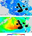
English: El Niño and La Niña, large-scale shifts in winds and currents in the equatorial Pacific, have dramatic effects on the ecosystems of the Galapagos. These satellite maps show chlorophyll concentration (which corresponds with the abundance of microscopic ocean plants, called phytoplankton) during El Niño (top) and La Niña (lower). Blue represents low concentrations, while yellow, orange and red indicate high concentrations. Currents that normally fertilize the phytoplankton reverse during El Niño, resulting in barren oceans. These same currents are strengthened by La Niña resulting in an explosion of ocean life.
Date
Source NASA Earth Observatory
Auteur GSFC Ocean Color team and GeoEye.

Images from the Sea-viewing Wide Field-of-view Sensor (SeaWiFS).

Conditions d’utilisation

Public domain Ce fichier provient de la NASA. Sauf exception, les documents créés par la NASA ne sont pas soumis à copyright. Pour plus d'informations, voir la politique de copyright de la NASA.
Attention :

Légendes

Ajoutez en une ligne la description de ce que représente ce fichier

Éléments décrits dans ce fichier

dépeint

image/jpeg

00144fead23ab88396e766eccc4027c1805d81b2

157 869 octet

535 pixel

468 pixel

Historique du fichier

Cliquer sur une date et heure pour voir le fichier tel qu'il était à ce moment-là.

Date et heureVignetteDimensionsUtilisateurCommentaire
actuel18 juillet 2009 à 11:42Vignette pour la version du 18 juillet 2009 à 11:42468 × 535 (154 kio)Originalwana{{Information |Description={{en|1=El Niño and La Niña, large-scale shifts in winds and currents in the equatorial Pacific, have dramatic effects on the ecosystems of the Galapagos. These satellite maps show chlorophyll concentration (which corresponds w

La page suivante utilise ce fichier :

Usage global du fichier

Les autres wikis suivants utilisent ce fichier :

Métadonnées