
Fichier:California state highways.svg

Taille de cet aperçu PNG pour ce fichier SVG : 514 × 600 pixels. Autres résolutions : 206 × 240 pixels | 411 × 480 pixels | 658 × 768 pixels | 878 × 1 024 pixels | 1 755 × 2 048 pixels | 576 × 672 pixels.
Fichier d’origine (Fichier SVG, nominalement de 576 × 672 pixels, taille : 1,61 Mio)
Ce fichier et sa description proviennent de Wikimedia Commons.
Description
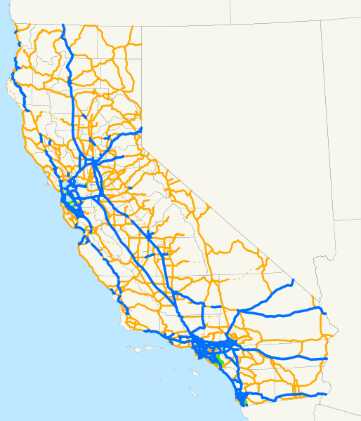
| Description | This is a map of the entire state highway system in California. Email me if you would like a copy of the GIS data I created for the highways. |
| Date | 9 février 2008 (date de téléversement originale) |
| Source | La source n’a pas pu être reconnue automatiquement. « Travail personnel » supposé (étant donné la revendication de droit d’auteur). |
| Auteur | L’auteur n’a pas pu être identifié automatiquement. Il est supposé qu'il s'agit de : NE2 (étant donné la revendication de droit d’auteur). |
Conditions d’utilisation
| Moi, propriétaire des droits d’auteur sur cette œuvre, la place dans le domaine public. Ceci s'applique dans le monde entier. Dans certains pays, ceci peut ne pas être possible ; dans ce cas : J’accorde à toute personne le droit d’utiliser cette œuvre dans n’importe quel but, sans aucune condition, sauf celles requises par la loi. |
Historique du fichier
Cliquer sur une date et heure pour voir le fichier tel qu'il était à ce moment-là.
| Date et heure | Vignette | Dimensions | Utilisateur | Commentaire | |
|---|---|---|---|---|---|
| actuel | 17 octobre 2019 à 21:15 | | 576 × 672 (1,61 Mio) | Jormy | with calcs |
| 9 février 2008 à 03:42 |  | 576 × 672 (1,25 Mio) | NE2 | == Summary == This is a map of the entire state highway system in California. Email me if you would like a copy of the GIS data I created for the highways. Category:State highways in California [[Category:Maps of state highw |
Utilisation du fichier
La page suivante utilise ce fichier :
Usage global du fichier
Les autres wikis suivants utilisent ce fichier :
- Utilisation sur en.wikipedia.org
- Utilisation sur es.wikipedia.org
- Utilisation sur www.wikidata.org