
Fichier:CT 4th Congressional District.png
Pas de plus haute résolution disponible.
CT_4th_Congressional_District.png (640 × 405 pixels, taille du fichier : 62 kio, type MIME : image/png)
Ce fichier et sa description proviennent de Wikimedia Commons.
Description

|
Ce fichier a été transféré sur Commons depuis en.wikipedia, de façon semi-automatique. Toutes les informations d'origine sont encore présentes, et il faut les vérifier. Il peut y avoir des erreurs dans la description, les catégories peuvent ne pas être les bonnes, ne faites pas confiance à cette description tant que ce bandeau est présent. Vous pouvez enlever le bandeau une fois que la description et les catégories ont été vérifiées. Vérifiez maintenant ! |
| Description |
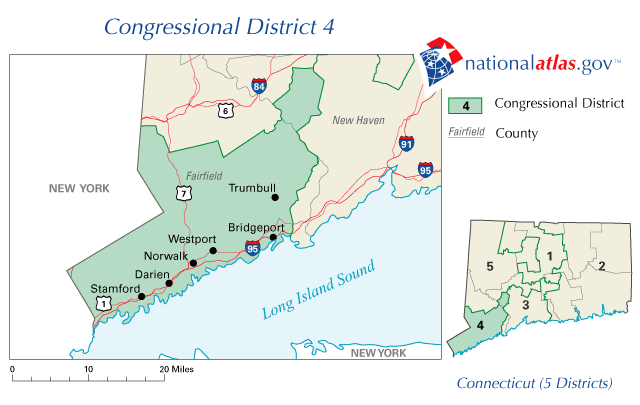
English: Map of Connecticut's 4th congressional district. Downloaded from http://nationalatlas.gov/printable/images/preview/congdist/ct04_109.gif and converted to PNG. |
| Source | Government of the United States |
| Auteur | Government of the United States |
Conditions d’utilisation
Cette carte a été obtenue d'une édition du
National Atlas of the United States . Comme presque toutes les œuvres du gouvernement fédéral des États-Unis d'Amérique, les travaux du National Atlas sont placés dans le domaine public.Version en ligne : NationalAtlas.gov | Édition imprimée de 1970 : Library of Congress, Perry-Castañeda Library
|
Journal des téléversements d’origine
La page de description originale était ici. Tous les noms d'utilisateur qui suivent se rapportent à en.wikipedia.
- 2006-12-22 09:45 Acntx 640×405× (63999 bytes) Map of Connecticut's 4th congressional district. Downloaded from http://nationalatlas.gov/printable/images/preview/congdist/ct04_109.gif and converted to PNG.
Historique du fichier
Cliquer sur une date et heure pour voir le fichier tel qu'il était à ce moment-là.
| Date et heure | Vignette | Dimensions | Utilisateur | Commentaire | |
|---|---|---|---|---|---|
| actuel | 12 janvier 2012 à 22:46 | | 640 × 405 (62 kio) | MGA73bot2 | {{BotMoveToCommons|en.wikipedia|year={{subst:CURRENTYEAR}}|month={{subst:CURRENTMONTHNAME}}|day={{subst:CURRENTDAY}}}} {{Information |Description={{en|Map of Connecticut's 4th congressional district. Downloaded from http://nationalatlas.gov/printable/i |
Utilisation du fichier
La page suivante utilise ce fichier :
Usage global du fichier
Les autres wikis suivants utilisent ce fichier :
- Utilisation sur en.wikipedia.org
- Utilisation sur fa.wikipedia.org