
Fichier:Bougainville Operation map.jpg

Fichier d’origine (562 × 798 pixels, taille du fichier : 158 kio, type MIME : image/jpeg)
Ce fichier et sa description proviennent de Wikimedia Commons.
Description
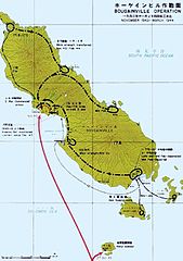
| Description |
English: Map of Japanese troop movements on Bougainville during the fighting on the island between November 1943 and March 1944 |
| Date | Created in or prior to 1950, first published in 1966 |
| Source | Reports of General MacArthur: JAPANESE OPERATIONS IN THE SOUTHWEST PACIFIC AREA. VOLUME II - PART I. Archivé de l'original (4 mars 2016). Accès 9 avril 2012. |
| Auteur | Not stated. The materials were provided to the US Army by the Japanese Demobilization Bureaux. The book was commissioned and published by the US Army |
Conditions d’utilisation
| Selon la Loi japonaise sur le Copyright (octroi du 1er juin 2018), ce travail est maintenant dans le domaine public au Japon car les droits d'auteurs des travaux au nom d'organisations, au Japon expirent 50 ans après leur publication, ou 50 ans après la création si les travaux ne sont pas publiés dans les 50 ans après la création (article 53)
À la personne téléverseuse : Veuillez fournir un nom d'organisation ainsi que l'année et la source de la publication.
Note : L'entrée en vigueur de la loi révisée sur le droit d'auteur le 30 décembre 2018 a porté à 70 ans la durée du droit d'auteur des œuvres dont le droit d'auteur était valable à cette date. N'utilisez pas ce modèle pour les œuvres publiées après 1967. Veuillez noter que le fait d'être dans le domaine public au Japon ne signifie pas automatiquement qu'il l'est également aux États-Unis. Trouvez et ajoutez l'un des bandeaux de licence américaine pour le domaine public pour vous assurer que le fichier est libre aux États-Unis. Typiquement, pour qu'un travail publié soit dans le domaine public aux États-Unis, il doit être publié avant 1946 à cause des droits d'auteur rétablis par l'URAA. Les travaux non publiés doivent satisfaire {{PD-US-unpublished}}.
|

|
Historique du fichier
Cliquer sur une date et heure pour voir le fichier tel qu'il était à ce moment-là.
| Date et heure | Vignette | Dimensions | Utilisateur | Commentaire | |
|---|---|---|---|---|---|
| actuel | 1 avril 2017 à 17:31 | | 562 × 798 (158 kio) | Hohum | Reverted to version as of 15:26, 1 April 2017 (UTC) |
| 1 avril 2017 à 17:27 |  | 562 × 798 (155 kio) | Hohum | Slightly brighter | |
| 1 avril 2017 à 17:26 |  | 562 × 798 (158 kio) | Hohum | Reworked colours | |
| 19 mai 2016 à 17:09 |  | 562 × 798 (152 kio) | Hohum | Cleanup | |
| 9 avril 2012 à 03:48 |  | 562 × 798 (98 kio) | Nick-D | {{Information |Description ={{en|1=Map of Japanese troop movements on Bougainville during the fighting on the island between November 1943 and March 1944}} |Source =http://www.history.army.mil/books/wwii/MacArthur%20Reports/MacArthur%20V2%20... |
Utilisation du fichier
La page suivante utilise ce fichier :
Usage global du fichier
Les autres wikis suivants utilisent ce fichier :
- Utilisation sur de.wikipedia.org
- Utilisation sur en.wikipedia.org
- Utilisation sur hu.wikipedia.org
- Utilisation sur ru.wikipedia.org