
Fichier:Bethesda, Burry Green - geograph.org.uk - 1313145.jpg
Pas de plus haute résolution disponible.
Bethesda,_Burry_Green_-_geograph.org.uk_-_1313145.jpg (640 × 480 pixels, taille du fichier : 83 kio, type MIME : image/jpeg)
Ce fichier et sa description proviennent de Wikimedia Commons.
Description
| Description |
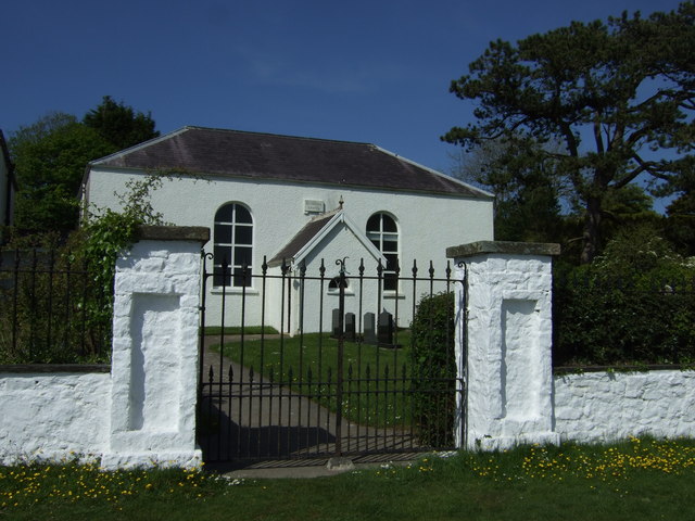
English: Bethesda, Burry Green Bethesda Chapel was built in 1813 or 1814 by Diana, Baroness Barham (d. 1823), who also built and established other chapels and schools in the area. During the first years, the Chapel was supplied by ministers of the Countess of Huntingdon's Connexion, staying for about two months at a time. The Rev. William Griffiths, the 'father' of Calvinistic Methodism in Gower, was appointed minister of the Chapel in 1824 under the patronage of Lord Barham, and remained there until his death.
The Rev. William Griffiths (1788-1861) was a Calvinistic Methodist minister, born at Clydau, Pembrokeshire. In 1807 he was forced to enlist in the militia and was influenced by the Methodists whom he later joined. In 1817, at the request of Lady Barham, he was sent as a missionary to the English-speaking community of Gower where he founded several churches. He is known as the 'Apostle of Gower'. |
| Date | |
| Source | From geograph.org.uk |
| Auteur | ceridwen |
| Attribution (imposé par la licence) | ceridwen / Bethesda, Burry Green / |
| Lieu de la prise de vue | | Voir cet endroit et d’autres images sur : OpenStreetMap |
|---|
_heading:45.00&language=fr)
| Position de l'objet | | Voir cet endroit et d’autres images sur : OpenStreetMap |
|---|
_heading:45.00&language=fr)
Conditions d’utilisation

|
Cette image provient de la collection du projet Geograph British Isles. Pour obtenir les coordonnées du photographe, veuillez consulter cette page de description de l'image sur le site du projet. Les droits d'auteurs sur cette image sont détenus par ceridwen ; l'image est placée sous une licence Creative Commons avec mention de paternité et partage à l'identique (CC-By-SA) en version 2.0.
|
Ce fichier est disponible selon les termes de la licence Creative Commons Attribution – Partage dans les Mêmes Conditions 2.0 Générique
Attribution: ceridwen
- Vous êtes libre :
- de partager – de copier, distribuer et transmettre cette œuvre
- d’adapter – de modifier cette œuvre
- Sous les conditions suivantes :
- paternité – Vous devez donner les informations appropriées concernant l'auteur, fournir un lien vers la licence et indiquer si des modifications ont été faites. Vous pouvez faire cela par tout moyen raisonnable, mais en aucune façon suggérant que l’auteur vous soutient ou approuve l’utilisation que vous en faites.
- partage à l’identique – Si vous modifiez, transformez, ou vous basez sur cette œuvre, vous devez distribuer votre contribution sous la même licence ou une licence compatible avec celle de l’original.
Historique du fichier
Cliquer sur une date et heure pour voir le fichier tel qu'il était à ce moment-là.
| Date et heure | Vignette | Dimensions | Utilisateur | Commentaire | |
|---|---|---|---|---|---|
| actuel | 27 février 2011 à 18:07 | | 640 × 480 (83 kio) | GeographBot | == {{int:filedesc}} == {{Information |description={{en|1=Bethesda, Burry Green Bethesda Chapel was built in 1813 or 1814 by Diana, Baroness Barham (d. 1823), who also built and established other chapels and schools in the area. During the first years, the |
Utilisation du fichier
La page suivante utilise ce fichier :
Usage global du fichier
Les autres wikis suivants utilisent ce fichier :
- Utilisation sur en.wikipedia.org