
Fichier:Benghazi Conflict Detailed Map.svg

Taille de cet aperçu PNG pour ce fichier SVG : 712 × 600 pixels. Autres résolutions : 285 × 240 pixels | 570 × 480 pixels | 912 × 768 pixels | 1 215 × 1 024 pixels | 2 431 × 2 048 pixels | 978 × 824 pixels.
Fichier d’origine (Fichier SVG, nominalement de 978 × 824 pixels, taille : 3,24 Mio)
Ce fichier et sa description proviennent de Wikimedia Commons.
Description
| Description |
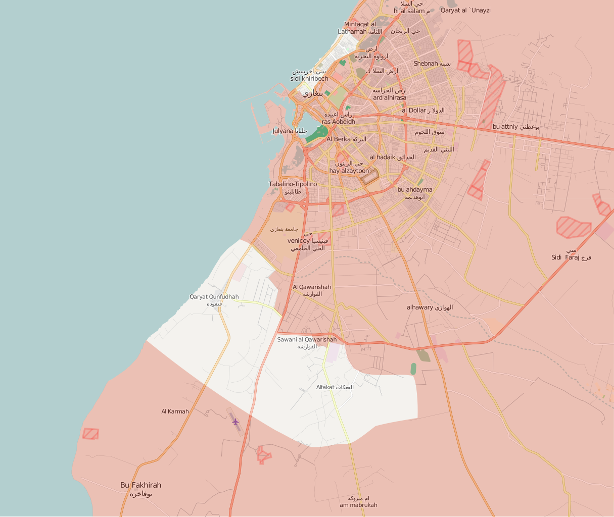
Deutsch:
Unter Kontrolle des Abgeordnetenrats in Tobruk und Verbündeten
Kontrolliert durch Revolutionärer Schura-Rat von Bengasi English:
Under the control of the Tobruk-led Government and Libyan National Army
Controlled by the Shura Council of Benghazi Revolutionaries Italiano:
Sotto il controllo del Governo di Tobruk e Alleati
Controllato dallo Consiglio consultivo dei rivoluzionari di Bengasi |
||||
| Date | |||||
| Source | Travail personnel, after the map from PutItOnAMap, basic map from http://www.openstreetmap.org. | ||||
| Auteur | Ermanarich | ||||
| Autres versions |
|


.svg)

.png)


.svg)


.svg)


_Territory_Change_2014-2016.gif)

_(within_Northern_Syria).svg)


.png)
.svg)


_map.png)
.svg)


.svg)


Conditions d’utilisation
Moi, en tant que détenteur des droits d’auteur sur cette œuvre, je la publie sous la licence suivante :
Ce fichier est sous la licence Creative Commons Attribution – Partage dans les Mêmes Conditions 4.0 International.
- Vous êtes libre :
- de partager – de copier, distribuer et transmettre cette œuvre
- d’adapter – de modifier cette œuvre
- Sous les conditions suivantes :
- paternité – Vous devez donner les informations appropriées concernant l'auteur, fournir un lien vers la licence et indiquer si des modifications ont été faites. Vous pouvez faire cela par tout moyen raisonnable, mais en aucune façon suggérant que l’auteur vous soutient ou approuve l’utilisation que vous en faites.
- partage à l’identique – Si vous modifiez, transformez, ou vous basez sur cette œuvre, vous devez distribuer votre contribution sous la même licence ou une licence compatible avec celle de l’original.
Historique du fichier
Cliquer sur une date et heure pour voir le fichier tel qu'il était à ce moment-là.
| Date et heure | Vignette | Dimensions | Utilisateur | Commentaire | |
|---|---|---|---|---|---|
| actuel | 4 janvier 2018 à 19:14 | | 978 × 824 (3,24 Mio) | MonsterHunter32 | Reverted to version as of 23:43, 22 August 2016 (UTC) so that the readers can see the situation when the battle was occuring. |
| 10 novembre 2017 à 17:00 |  | 1 044 × 879 (3,21 Mio) | Kami888 | Revert - turns out Sidi Akribesh was never captured after all | |
| 10 juillet 2017 à 14:15 |  | 1 044 × 879 (3,21 Mio) | Kami888 | LNA claims last militants are defeated, the battle is over. https://www.libyaherald.com/2017/07/09/breaking-lna-says-tonight-it-has-taken-last-benghazi-militant-positions/ | |
| 7 juillet 2017 à 06:06 |  | 1 044 × 879 (3,21 Mio) | Kami888 | Hospital, hotel, and most of the Sabri district is claimed by LNA. Last militants are holding out in Sidi Akribesh. https://www.libyaherald.com/2017/07/05/breaking-lna-says-benghazis-sabri-has-all-but-fallen/ https://www.libyaherald.com/2017/07/06/lead... | |
| 25 juin 2017 à 05:01 |  | 1 044 × 879 (3,21 Mio) | Kami888 | suddenly... souq al hout and eastern sabri reportedly taken as militants flee. Clashes at Sharif Street in the west and at wahda (sabri branch) bank in the east. https://www.libyaherald.com/2017/06/23/benghazis-suq-al-hout-finally-taken-says-lna-heavin... | |
| 22 juin 2017 à 02:20 |  | 1 044 × 879 (3,21 Mio) | Kami888 | Fish market (Souk al Hout), Erkheis mosque, and much of the Al-Ageeb street is captured. Using a relatively conservative estimate since the capture of the Christian churches has not been reported. https://www.libyaherald.com/2017/06/19/lna-says-it-has-... | |
| 19 juin 2017 à 08:40 |  | 1 044 × 879 (3,21 Mio) | Kami888 | wahda bank & misrata street in souq-al-hout to red https://www.libyaherald.com/2017/06/16/five-lna-soldiers-killed-in-suq-al-hout-offensive/ | |
| 15 juin 2017 à 03:21 |  | 1 044 × 879 (3,21 Mio) | Kami888 | Tahrir square and courthouse captured https://www.libyaherald.com/2017/06/13/benghazis-iconic-tahrir-square-taken-by-lna-as-suq-al-hout-hit-by-airstrikes/ | |
| 13 juin 2017 à 10:51 |  | 1 044 × 879 (3,21 Mio) | Kami888 | Adjusted frontlines based on multiple sources linked in talk page. Also added an unclear area where I just can't figure out what is happening. In line with the similar maps that area is marked in #8080007b. This change does not represent SCBR advance. | |
| 23 mars 2017 à 03:25 |  | 1 044 × 879 (3,24 Mio) | Kami888 | https://www.libyaherald.com/2017/03/18/breaking-ganfouda-12-apartments-complex-finally-taken/ |
Utilisation du fichier
La page suivante utilise ce fichier :
Usage global du fichier
Les autres wikis suivants utilisent ce fichier :
- Utilisation sur ar.wikipedia.org
- Utilisation sur be.wikipedia.org
- Utilisation sur en.wikipedia.org
- Utilisation sur es.wikipedia.org
- Utilisation sur fa.wikipedia.org
- Utilisation sur pt.wikipedia.org
- Utilisation sur ru.wikipedia.org
- Utilisation sur www.wikidata.org