
Fichier:Battle of Wauhatchie map.jpg

Fichier d’origine (2 082 × 2 214 pixels, taille du fichier : 2,77 Mio, type MIME : image/jpeg)
Ce fichier et sa description proviennent de Wikimedia Commons.
Description
| Description |
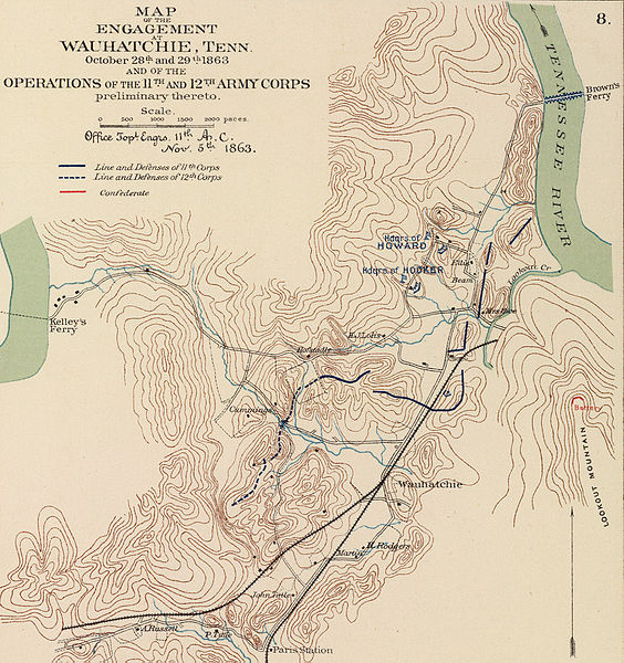
English: Author: Morris, Walter J.; United States. War Department
Date: 1895 Short Title: Army of Missouri campaigns. Publisher: Washington: U.S. Government Printing Office Type: Atlas Map Obj Height cm: 43 Obj Width cm: 70 Scale 1: 2,217,600 Note: Col. map with 7 ancillary maps. Relief in some ancillary maps shown by hachures or form lines. State/Province: Missouri ; Arkansas ; Oklahoma ; Georgia County: Walker County (Ga.) ; Spotsylvania County (Va.) Event: U.S. Civil War Subject: Military Full Title: Map of the fall campaigns of the Army of Missouri, Maj. Gen. Sterling Price, commanding in Sept., Oct., Nov. 1864. Capt. T.J. Mackey, Chf. Engr. (with) No. 2. Map of the battle of Chickamauga showing the positions of the Confederate and Federal armies on the 19th September, 1863 ... by Walter J. Morris ... (with) No. 3. Map of the battle of Chickamauga ... 19th September 1863 ... by Walter J. Morris ... (with Marietta Region, Georgia). Accompanying letter of Maj. Gen. J.M. Scholfield ... (with Peach Tree Creek Region, Georgia) Marked "Thomas" by Gen. Sherman. (with) Mine Run, Va. and vicinity, 1863. (with) No. 1. Map showing the positions of the Confederate Army and that of the Federal Army at midnight on the 18th of September, 1863, the night previous to the general engagements of the 19th and 20th Sept., or the Battle of Chickamauga ... by Walter J. Morris ... (with) Map of the engagement at Wauhatchie, Tenn., October 28th and 29th, 1863 and of the operations of the 11th and 12th Army Corps preliminary thereto. To accompany report of Maj. Gen. Joseph Hooker. Julius Bien & Co., Lith., N.Y. (1891-1895) Engraver or Printer: Julius Bien & Co. ; Price, Sterling ; Mackey, Thomas J. ; Schofield, John M. ; Thomas, George H. ; Sherman, William T. ; Hooker, Joseph Publication Author: United States. War Department; Davis, George B.; Perry, Leslie J.; Kirkley, JAW.; Cowles, Calvin D. Pub Date: 1895 Pub Title: Atlas to accompany the official records of the Union and Confederate armies. Published under the direction of the Hons. Redfield Proctor, Stephen B. Elkins and Daniel S. Lamont, secretaries of war, by Maj. George B. Davis, U.S. Army, Mr. Leslie J. Perry, civilian expert, Mr. Joseph W. Kirkley, civilian expert, Board of Publication. Compiled by Capt. Calvin D. Cowles, 23d U.S. Infantry. Washington: Government Printing Office, 1891-1895. Pub Reference: LC Civil War maps (2nd ed.), 99; Civil War maps in the National Archives, 8; Phillips, 1353; LeGear. Atlases of the United States, 266. http://www.davidrumsey.com/rumsey/download.pl?image=/D0110/1780047.sid (need MrSid viewer) |
| Source | Source inconnue |
| Auteur | Auteur inconnu |
Conditions d’utilisation
|
Ceci est une reproduction photographique fidèle d'une œuvre d'art originale en deux dimensions. L'œuvre d'art elle-même est dans le domaine public pour la raison suivante :
La position officielle de la Fondation Wikimedia est que « les représentations fidèles des œuvres d'art du domaine public en deux dimensions sont dans le domaine public et les exigences contraires sont une attaque contre le concept même de domaine public ». Pour plus de détails, voir Commons:Quand utiliser le bandeau PD-Art.
Cette reproduction photographique est donc également considérée comme étant élevée dans le domaine public. Merci de noter qu'en fonction des lois locales, la réutilisation de ce contenu peut être interdite ou restreinte dans votre juridiction. Voyez Commons:Reuse of PD-Art photographs. |


Journal des téléversements d’origine
| Date et heure | Dimensions | Utilisateur | Commentaire |
|---|---|---|---|
| 2005-04-07 12:12 | 2082×2214× (2900377 bytes) | Brian0918 | Author: Morris, Walter J.; United States. War Department Date: 1895 Short Title: Army of Missouri campaigns. Publisher: Washington: U.S. Government Printing Office Type: Atlas Map Obj Height cm: 43 Obj Width cm: 70 Scale 1: 2,217,600 Note: C |
Historique du fichier
Cliquer sur une date et heure pour voir le fichier tel qu'il était à ce moment-là.
| Date et heure | Vignette | Dimensions | Utilisateur | Commentaire | |
|---|---|---|---|---|---|
| actuel | 3 avril 2016 à 10:00 | | 2 082 × 2 214 (2,77 Mio) | Tikky19 | Transferred from en.wikipedia |
Utilisation du fichier
La page suivante utilise ce fichier :
Usage global du fichier
Les autres wikis suivants utilisent ce fichier :
- Utilisation sur en.wikipedia.org
- Utilisation sur en.wikivoyage.org
- Utilisation sur it.wikipedia.org
- Utilisation sur ru.wikipedia.org
- Utilisation sur www.wikidata.org