
Fichier:Baden Railwaymap 1870.png

Taille de cet aperçu : 429 × 599 pixels. Autres résolutions : 172 × 240 pixels | 344 × 480 pixels | 550 × 768 pixels | 733 × 1 024 pixels | 1 364 × 1 904 pixels.
Fichier d’origine (1 364 × 1 904 pixels, taille du fichier : 247 kio, type MIME : image/png)
Ce fichier et sa description proviennent de Wikimedia Commons.
Description
| Description |
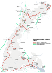
Map of the railway lines in Baden 1870 Deutsch: Plan der Eisenbahnstrecken in Baden 1870 |
| Date | 15 janvier 2006 (date de téléversement) |
| Source | map created by MCMC |
| Auteur | MCMC |
| Autorisation (Réutilisation de ce fichier) |
MCMC puts it under CC-By-SA |
Conditions d’utilisation
Ce fichier est disponible selon les termes de la licence Creative Commons Attribution 2.5 Générique.
- Vous êtes libre :
- de partager – de copier, distribuer et transmettre cette œuvre
- d’adapter – de modifier cette œuvre
- Sous les conditions suivantes :
- paternité – Vous devez donner les informations appropriées concernant l'auteur, fournir un lien vers la licence et indiquer si des modifications ont été faites. Vous pouvez faire cela par tout moyen raisonnable, mais en aucune façon suggérant que l’auteur vous soutient ou approuve l’utilisation que vous en faites.
Historique du fichier
Cliquer sur une date et heure pour voir le fichier tel qu'il était à ce moment-là.
| Date et heure | Vignette | Dimensions | Utilisateur | Commentaire | |
|---|---|---|---|---|---|
| actuel | 15 janvier 2006 à 02:15 | | 1 364 × 1 904 (247 kio) | MCMC | {{Information| |Description = Map of the railway lines in Baden 1870 |Source = map created by MCMC |Date = created 15. Jan. 2006 |Author = Martin Lauer (User MCMC) |Permission = MCMC puts it under CC-By-SA |othe |
Utilisation du fichier
La page suivante utilise ce fichier :
Usage global du fichier
Les autres wikis suivants utilisent ce fichier :
- Utilisation sur als.wikipedia.org
- Utilisation sur de.wikipedia.org
- Utilisation sur en.wikipedia.org
- Utilisation sur ja.wikipedia.org
- Utilisation sur www.wikidata.org