
Fichier:Austria satellite Grosslandschaften markerstyle.png
Taille de cet aperçu : 800 × 429 pixels. Autres résolutions : 320 × 172 pixels | 640 × 343 pixels | 1 024 × 549 pixels | 1 280 × 687 pixels | 2 457 × 1 318 pixels.
Fichier d’origine (2 457 × 1 318 pixels, taille du fichier : 6,11 Mio, type MIME : image/png)
Ce fichier et sa description proviennent de Wikimedia Commons.
| Description |
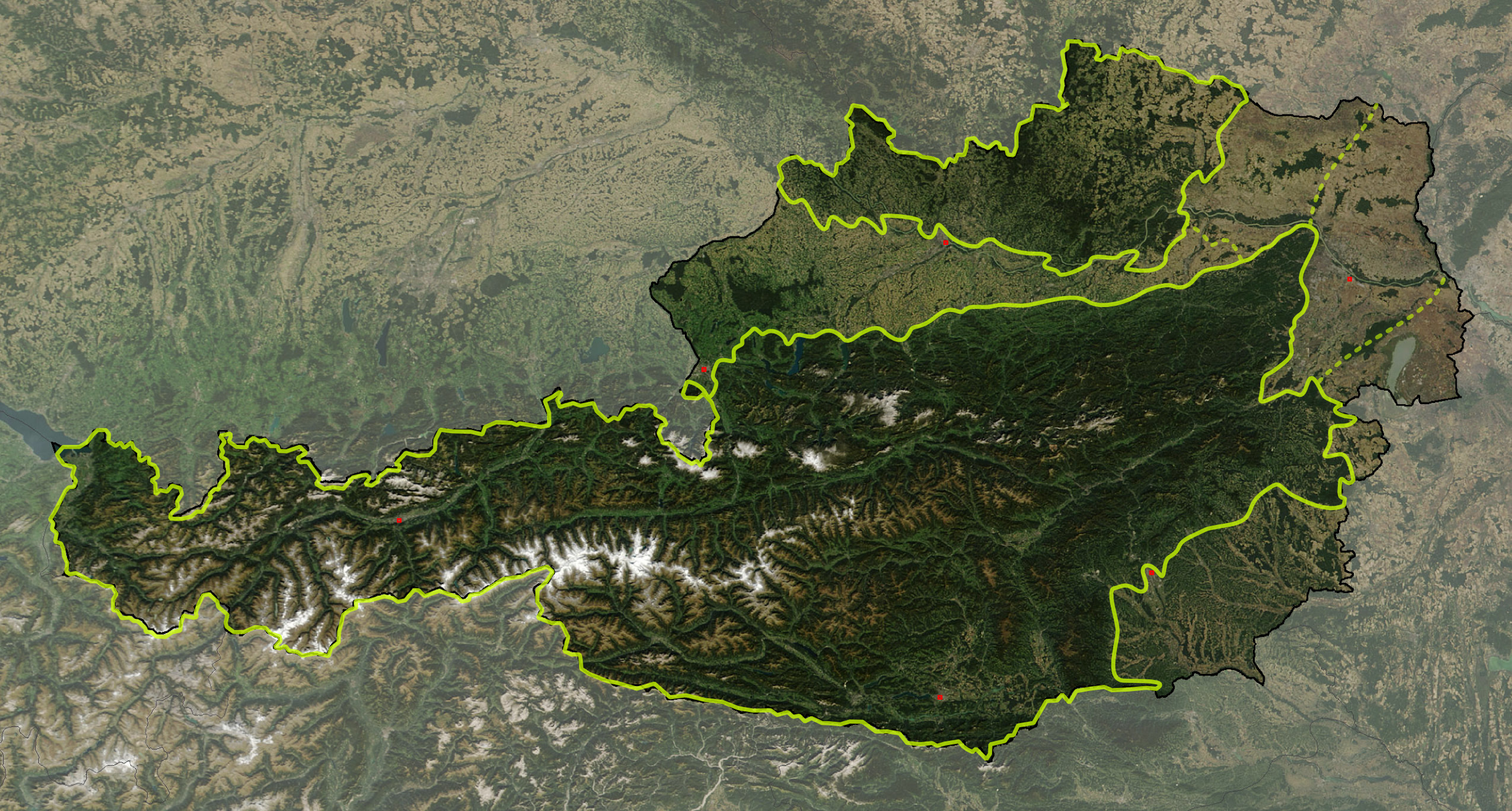
Deutsch: Satellitenbild von Österreich, mit den Großlandschaften: Österreichische Alpen, Vorländer und randalpine Becken, Granit- und Gneishochland
English: Satellite image of Austria with greater landscapes: Austrian Alps, Alpine Forelands and Rim Basins, Granite and Gneiss Highlands |
||
| Date | |||
| Source | The image is based on a satellite image from [1]. Original image: Credit Jeff Schmaltz, MODIS Rapid Response Team, NASA/GSFC. It was cropped and reduced in contrast around Austria by Michael Schmid, which is Image:Austria satellite unannotated.jpg. Borderlines added with Inkscape. | ||
| Auteur | W!B: | ||
| Autorisation (Réutilisation de ce fichier) |
Based on a NASA image, thus in the public domain. | ||
| PNG information |
|
![[1]](http://visibleearth.nasa.gov/images/5947/Italy.A2003262.1005.250m.jpg)
The borders of Austrian greater landscapes are derived from:
- Alps:
- W. Kilian, F. Müller, F. Starlinger: Die forstlichen Wuchsgebiete Österreichs. Eine Naturraumgliederung nach waldökologischen Gesichtspunkten. Forstliche Bundesversuchsanstalt, Wien 1993, ISSN 0374-9037 – online version
- They are slightly simplyfied and adjusted according to local customs, following the Alpenvereinsteilung der Ostalpen and on the NASA MODIS photo.
- The border of Granite and Gneiss Highlands is adjusted to the borders of Bohemian Mass to reflect the area, given in
- K. Ash: The 1:5 Million International Geological Map of Europe and Adjacent Areas., BGR, Hannover 2005
- Geologische Übersichtskarte der Republik Österreich. ed. Geologische Bundesanstalt, Vienna 1999
- Alpine Forelands: The borders between Alpine-Carpathian Forlands, Vienna Basin and Pannonian Basin follows visually the ridgelines of Alpine-Carpathian Cliffzone and Leithagebirge – Little Carpathians
The image is adjusted by some exactly referenced points (eg. capitals, NSEW extrempoints, ..) by geographical coordinate to rectangular othogonal projection, and stored 300 dpi, so it has a slightly different size (2457 x 1318 px) than Michael Schmid's image (2550 x 1381 px) – resizing was quite lossy with Inkscape, I'll fix that sometimes with Photoshop.
- Note, the darker shade of the Alps and the Granite and Gneiss Highlands ist not retouched, but from the original satellite picture: It reflects that these areas are mainly covered by forests (about 60% of Austria), while the Alpine Forelands are primarily agricultural regions – note the Kobernaußerwald/Hausruck forests of central Northern Forlands, Allentsteig region at northeast and Rosalia near Neusiedlersee at the far east)
| Ce fichier provient de la NASA. Sauf exception, les documents créés par la NASA ne sont pas soumis à copyright. Pour plus d'informations, voir la politique de copyright de la NASA. | ||
 |
Attention :
|
Historique du fichier
Cliquer sur une date et heure pour voir le fichier tel qu'il était à ce moment-là.
| Date et heure | Vignette | Dimensions | Utilisateur | Commentaire | |
|---|---|---|---|---|---|
| actuel | 18 mars 2008 à 13:57 | | 2 457 × 1 318 (6,11 Mio) | W!B: | {{Information |Description= |Source=The image is based on a satellite image from [http://visibleearth.nasa.gov/images/5947/Italy.A2003262.1005.250m.jpg]. Original image: Credit Jeff Schmaltz, MODIS Rapid Response Team, NASA/GSFC. It was cropped and reduc |
Utilisation du fichier
La page suivante utilise ce fichier :
Usage global du fichier
Les autres wikis suivants utilisent ce fichier :
- Utilisation sur cs.wikipedia.org
- Utilisation sur de.wikipedia.org
- Utilisation sur hu.wikipedia.org
- Utilisation sur is.wikipedia.org
- Utilisation sur ka.wikipedia.org
- Utilisation sur sv.wikipedia.org
- Utilisation sur www.wikidata.org