
Fichier:Asia Europe transcontinental.png

Taille de cet aperçu : 763 × 599 pixels. Autres résolutions : 306 × 240 pixels | 611 × 480 pixels | 978 × 768 pixels | 1 268 × 996 pixels.
Fichier d’origine (1 268 × 996 pixels, taille du fichier : 46 kio, type MIME : image/png)
Ce fichier et sa description proviennent de Wikimedia Commons.
| Description |
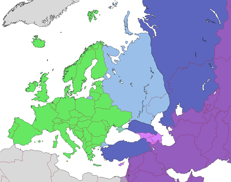
English: Map of Europe, indicating continental boundary (by Britannica and Great Soviet Encyclopedia) and transcontinental states.
States geographically in Europe (excepting overseas possessions)
Transcontinental states, European territory
Transcontinental states, Asian territory
Asian countries, sometimes referred to as Europe according to political, economic, and historical and cultural criteria (Azerbaijan, Armenia, Georgia, Cyprus)
Geographically Asian states (island states of Cyprus and Bahrain usually grouped with Asia geographically)
Asian part of Egypt Русский: Карта Европы с указанием границ частей света (по БСЭ и Британнике) и трансконтинентальных государств.
Государства, расположенные в Европе (за исключением заморских владений)
Трансконтинентальные государства, европейская территория
Трансконтинентальные государства, азиатская территория
Государства Азии, иногда относимые к Европе по политическим, экономическим, и историко-культурным критериям
Государства, расположенные в Азии
Азиатская часть Египта |
| Date | |
| Source | |
| Auteur |
.png)
Conditions d’utilisation
Ce fichier est disponible selon les termes de la licence Creative Commons Attribution – Partage dans les Mêmes Conditions 3.0 (non transposée).
- Vous êtes libre :
- de partager – de copier, distribuer et transmettre cette œuvre
- d’adapter – de modifier cette œuvre
- Sous les conditions suivantes :
- paternité – Vous devez donner les informations appropriées concernant l'auteur, fournir un lien vers la licence et indiquer si des modifications ont été faites. Vous pouvez faire cela par tout moyen raisonnable, mais en aucune façon suggérant que l’auteur vous soutient ou approuve l’utilisation que vous en faites.
- partage à l’identique – Si vous modifiez, transformez, ou vous basez sur cette œuvre, vous devez distribuer votre contribution sous la même licence ou une licence compatible avec celle de l’original.
| Annotations | Cette image est annotée : Voir les annotations sur Wikimedia Commons |
Historique du fichier
Cliquer sur une date et heure pour voir le fichier tel qu'il était à ce moment-là.
| Date et heure | Vignette | Dimensions | Utilisateur | Commentaire | |
|---|---|---|---|---|---|
| actuel | 14 novembre 2022 à 12:23 | | 1 268 × 996 (46 kio) | Рагин1987 | Highlighted with a light purple hue the countries of Asia, sometimes attributed to Europe according to political, economic, and historical and cultural criteria (Transcaucasia, Cyprus). |
| 29 août 2022 à 14:02 |  | 1 268 × 996 (46 kio) | Рагин1987 | Small correction | |
| 18 février 2020 à 09:03 |  | 1 268 × 996 (56 kio) | Insider | fix: mixed color. not dark blue | |
| 18 février 2020 à 08:55 |  | 1 268 × 996 (60 kio) | Insider | Reverted to version as of 07:01, 13 October 2014 (UTC) Crimea that is Europe | |
| 10 février 2020 à 11:04 |  | 1 268 × 996 (84 kio) | Compu wiki | Крым — это Россия. Crimea is Russia. | |
| 13 octobre 2014 à 09:01 |  | 1 268 × 996 (60 kio) | Insider | Reverted to version as of 10:10, 1 July 2014 Crimea that is Europe | |
| 11 octobre 2014 à 14:31 |  | 1 268 × 996 (84 kio) | Michael1238 | Crimea | |
| 1 juillet 2014 à 12:10 |  | 1 268 × 996 (60 kio) | Insider | {{Information |Description={{en|1= Map of Europe, indicating continental boundary and transcontinental states. {{legend|#67e836|States geographically in Europe (excepting overseas possessions; island states UK, Ireland, Iceland and Malta usually group... |
Utilisation du fichier
Aucune page n’utilise ce fichier.
Usage global du fichier
Les autres wikis suivants utilisent ce fichier :
- Utilisation sur hy.wikipedia.org
- Utilisation sur kk.wikipedia.org
- Utilisation sur ru.wikipedia.org