
Fichier:Arctic Ocean bathymetric features.png

Taille de cet aperçu : 725 × 600 pixels. Autres résolutions : 290 × 240 pixels | 581 × 480 pixels | 803 × 664 pixels.
Fichier d’origine (803 × 664 pixels, taille du fichier : 664 kio, type MIME : image/png)
Ce fichier et sa description proviennent de Wikimedia Commons.
Description
| Description |
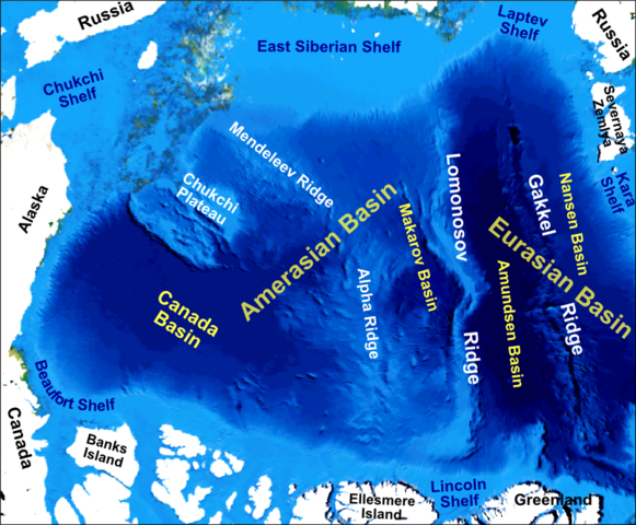
English: Main bathymetric features of the Arctic Ocean, taken mainly from Weber 1983 'Maps of the Arctic Basin Sea Floor: A History of Bathymetry and its Interpretation' on a base of a screenshot taken from the NASA WorldWind software |
| Date | |
| Source | Travail personnel |
| Auteur | Mikenorton |
Conditions d’utilisation
Moi, en tant que détenteur des droits d’auteur sur cette œuvre, je la publie sous la licence suivante :
Ce fichier est disponible selon les termes de la licence Creative Commons Attribution – Partage dans les Mêmes Conditions 3.0 (non transposée).
- Vous êtes libre :
- de partager – de copier, distribuer et transmettre cette œuvre
- d’adapter – de modifier cette œuvre
- Sous les conditions suivantes :
- paternité – Vous devez donner les informations appropriées concernant l'auteur, fournir un lien vers la licence et indiquer si des modifications ont été faites. Vous pouvez faire cela par tout moyen raisonnable, mais en aucune façon suggérant que l’auteur vous soutient ou approuve l’utilisation que vous en faites.
- partage à l’identique – Si vous modifiez, transformez, ou vous basez sur cette œuvre, vous devez distribuer votre contribution sous la même licence ou une licence compatible avec celle de l’original.
Historique du fichier
Cliquer sur une date et heure pour voir le fichier tel qu'il était à ce moment-là.
| Date et heure | Vignette | Dimensions | Utilisateur | Commentaire | |
|---|---|---|---|---|---|
| actuel | 10 novembre 2012 à 02:12 | | 803 × 664 (664 kio) | Mikenorton | The 'Fram Basin' is now known as the 'Amundsen Basin' and the location of the two basins either side of the Gakkel Ridge has now been corrected |
| 2 octobre 2011 à 13:21 |  | 2 408 × 1 993 (1,42 Mio) | Mikenorton |
Utilisation du fichier
Les 7 pages suivantes utilisent ce fichier :
Usage global du fichier
Les autres wikis suivants utilisent ce fichier :
- Utilisation sur ar.wikipedia.org
- Utilisation sur az.wikipedia.org
- Utilisation sur be.wikipedia.org
- Utilisation sur ca.wikipedia.org
- Utilisation sur cs.wikipedia.org
- Utilisation sur de.wikipedia.org
- Utilisation sur en.wikipedia.org
- Gakkel Ridge
- Lomonosov Ridge
- Litke Deep
- Mendeleev Ridge
- Alpha Ridge
- Siberian Shelf
- Eurasian Basin
- Amerasia Basin
- Chukchi Shelf
- Arctic Basin
- Arctic policy of Canada
- Talk:Arctic policy of Canada
- Canada Basin
- Makarov Basin
- Template:Did you know nominations/Geology of the Pacific Ocean
- Chukchi Plateau
- Gakkel Ridge Caldera
- Utilisation sur en.wikiversity.org
- Utilisation sur eo.wikipedia.org
- Utilisation sur es.wikipedia.org
- Utilisation sur fa.wikipedia.org
Voir davantage sur l’utilisation globale de ce fichier.