
Fichier:Arabia Armistice Mudros.png

Fichier d’origine (3 242 × 3 572 pixels, taille du fichier : 1,12 Mio, type MIME : image/png)
Ce fichier et sa description proviennent de Wikimedia Commons.
Description
| Description |
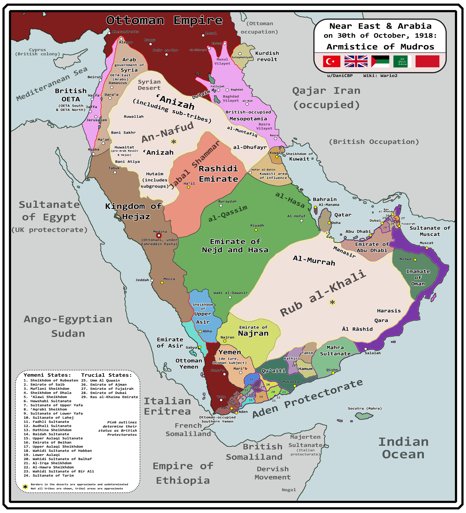
English: Map of Arabia and the Near East at the end of World War I, in October 30th, 1918, day of the Armistice of Mudros. |
| Date | |
| Source |
Travail personnel + Ashkenazi, T. (1948). The ’Anazah Tribes. Southwestern Journal of Anthropology, 4(2), 222–239. http://www.jstor.org/stable/3628713 H. St. J. B. Philby. (1920). Southern Najd. The Geographical Journal, 55(3), 161–185. https://doi.org/10.2307/1781600 Haines, S. B. (1839). Memoir, to Accompany a Chart of the South Coast of Arabia from the Entrance of the Red Sea to Misenát, in 50° 43′ 25″ E. The Journal of the Royal Geographical Society of London, 9, 125–156. https://doi.org/10.2307/1797718 Helfritz, H. (1935). The First Crossing of Southwestern Arabia. Geographical Review, 25(3), 395–407. https://doi.org/10.2307/209308 Thomas, B. (1929). Among Some Unknown Tribes of South Arabia. The Journal of the Royal Anthropological Institute of Great Britain and Ireland, 59, 97–111. https://doi.org/10.2307/2843560 Anderson, S. (2014). Lawrence in Arabia: War, Deceit, Imperial Folly and the Making of the Modern Middle East. Atlantic Books Ltd. Boxberger, L. (2012). On the Edge of Empire: Hadhramawt, Emigration, and the Indian Ocean, 1880s–1930s. SUNY Press. J. E. Peterson. (1976) "The Revival of the Ibadi Imamate in Oman and the Threat to Muscat, 1913–20," Arabian Studies 3 Al-Maghafi, Fadhl (2012). "MORE THAN JUST A BOUNDARY DISPUTE: THE REGIONAL GEOPOLITICS OF SAUDI-YEMENI RELATIONS" (PDF). eprints.soas.ac.uk Bang, Anne (1997). The Idrisi State in Asir 1906–1934. Hurst Publishers. pp. 111–114. ISBN 9781850653066. Eskander, S. "Britain's Policy Towards The Kurdish Question, 1915-1923" (PDF). etheses.lse.ac.uk. |
| Auteur | Wario2 |
Conditions d’utilisation
- Vous êtes libre :
- de partager – de copier, distribuer et transmettre cette œuvre
- d’adapter – de modifier cette œuvre
- Sous les conditions suivantes :
- paternité – Vous devez donner les informations appropriées concernant l'auteur, fournir un lien vers la licence et indiquer si des modifications ont été faites. Vous pouvez faire cela par tout moyen raisonnable, mais en aucune façon suggérant que l’auteur vous soutient ou approuve l’utilisation que vous en faites.
Historique du fichier
Cliquer sur une date et heure pour voir le fichier tel qu'il était à ce moment-là.
| Date et heure | Vignette | Dimensions | Utilisateur | Commentaire | |
|---|---|---|---|---|---|
| actuel | 13 mars 2024 à 12:18 | | 3 242 × 3 572 (1,12 Mio) | Wario2 | Uploaded own work with UploadWizard |
Utilisation du fichier
La page suivante utilise ce fichier :
Usage global du fichier
Les autres wikis suivants utilisent ce fichier :
- Utilisation sur ar.wikipedia.org
- Utilisation sur en.wikipedia.org
- Utilisation sur es.wikipedia.org
- Utilisation sur mt.wikipedia.org