
Fichier:Antarctica Farthest Souths.svg

Taille de cet aperçu PNG pour ce fichier SVG : 532 × 599 pixels. Autres résolutions : 213 × 240 pixels | 426 × 480 pixels | 682 × 768 pixels | 909 × 1 024 pixels | 1 818 × 2 048 pixels | 1 144 × 1 289 pixels.
Fichier d’origine (Fichier SVG, nominalement de 1 144 × 1 289 pixels, taille : 63 kio)
Ce fichier et sa description proviennent de Wikimedia Commons.
Description
| Description |
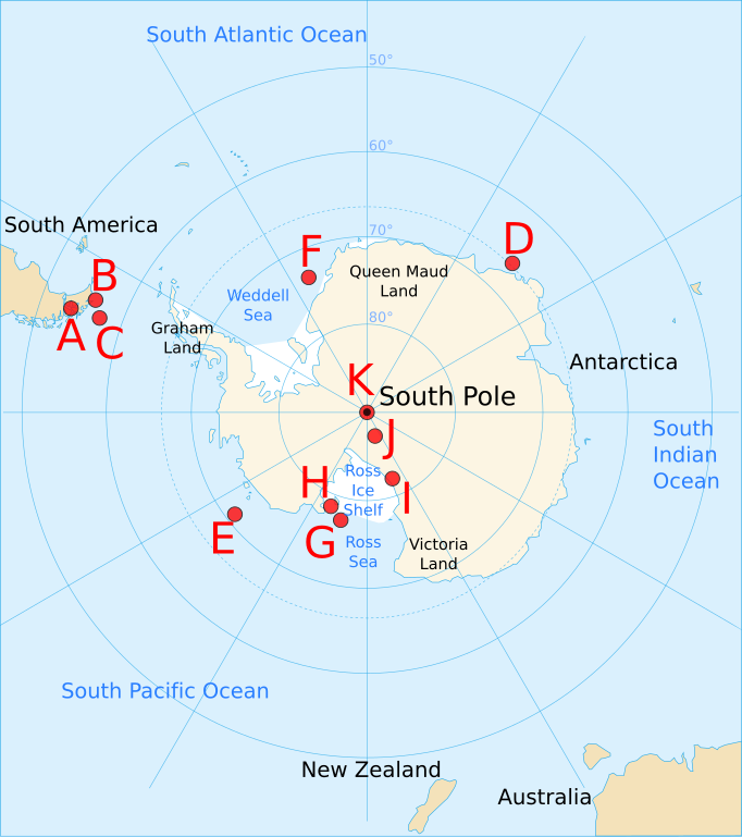
English: Map of Antarctica and the southern hemisphere for the w:Farthest South article, showing farthest south records from 1521 to 1911, as follows:
|
| Date | |
| Source | Based on Image:Antarctica blank.svg, Image:Antarctica Map.png, and Image:Farthest South map.png |
| Auteur | Jappalang |
| Autres versions |
Image:Farthest South map.png — based on this PNG version
|


Cette image vectorielle SVG non W3C-spécifiée a été créée avec Inkscape .
Conditions d’utilisation
Moi, en tant que détenteur des droits d’auteur sur cette œuvre, je la publie sous les licences suivantes :
Ce fichier est disponible selon les termes de la licence Creative Commons Attribution – Partage dans les Mêmes Conditions 3.0 (non transposée).
- Vous êtes libre :
- de partager – de copier, distribuer et transmettre cette œuvre
- d’adapter – de modifier cette œuvre
- Sous les conditions suivantes :
- paternité – Vous devez donner les informations appropriées concernant l'auteur, fournir un lien vers la licence et indiquer si des modifications ont été faites. Vous pouvez faire cela par tout moyen raisonnable, mais en aucune façon suggérant que l’auteur vous soutient ou approuve l’utilisation que vous en faites.
- partage à l’identique – Si vous modifiez, transformez, ou vous basez sur cette œuvre, vous devez distribuer votre contribution sous la même licence ou une licence compatible avec celle de l’original.

|
Vous avez la permission de copier, distribuer et modifier ce document selon les termes de la GNU Free Documentation License version 1.2 ou toute version ultérieure publiée par la Free Software Foundation, sans sections inaltérables, sans texte de première page de couverture et sans texte de dernière page de couverture. Un exemplaire de la licence est inclus dans la section intitulée GNU Free Documentation License. |
Vous pouvez choisir l’une de ces licences.
Historique du fichier
Cliquer sur une date et heure pour voir le fichier tel qu'il était à ce moment-là.
| Date et heure | Vignette | Dimensions | Utilisateur | Commentaire | |
|---|---|---|---|---|---|
| actuel | 2 octobre 2008 à 14:01 | | 1 144 × 1 289 (63 kio) | Jappalang | Corrected some locations (with respect to latitude) and added latitude labels |
| 2 octobre 2008 à 06:11 |  | 1 144 × 1 289 (62 kio) | Jappalang | Corrected size and added labels | |
| 2 octobre 2008 à 02:50 |  | 804 × 804 (52 kio) | Jappalang | {{Information |Description={{en|1=Map of Antarctica and the southern hemisphere for the w:Farthest South article, showing farthest south records from 1521 to 1911, as follows: :A Magellan 54°S, 71°W (approx, - longitude wasn't understood then) :B |
Utilisation du fichier
La page suivante utilise ce fichier :
Usage global du fichier
Les autres wikis suivants utilisent ce fichier :
- Utilisation sur ang.wikipedia.org
- Utilisation sur en.wikipedia.org
- Utilisation sur it.wikipedia.org
- Utilisation sur ja.wikipedia.org
- Utilisation sur pt.wikipedia.org