
Fichier:Anglo-Romance Language World.PNG
Taille de cet aperçu : 800 × 370 pixels. Autres résolutions : 320 × 148 pixels | 640 × 296 pixels | 1 199 × 555 pixels.
Fichier d’origine (1 199 × 555 pixels, taille du fichier : 158 kio, type MIME : image/png)
Ce fichier et sa description proviennent de Wikimedia Commons.
Description

|
Cette image (de type linguistic map) devrait être recréée dans un format vectoriel, en tant que fichier SVG. Cela offrirait plusieurs avantages : voir Commons:Media for cleanup pour plus d'informations. Si une version SVG de cette image est déjà disponible, merci de bien vouloir l'envoyer. Après cela, remplacez ce modèle par {{vector version available|nouveau nom d'image.svg}}.
|
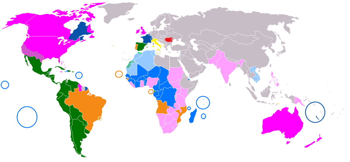
| Description | A combination of Image:Map-Romance Language World.png (Romance languages) and Image:Anglospeak.svg |
| Date | |
| Source | Travail personnel |
| Auteur | 16@r |
Conditions d’utilisation
| Moi, propriétaire des droits d’auteur sur cette œuvre, la place dans le domaine public. Ceci s'applique dans le monde entier. Dans certains pays, ceci peut ne pas être possible ; dans ce cas : J’accorde à toute personne le droit d’utiliser cette œuvre dans n’importe quel but, sans aucune condition, sauf celles requises par la loi. |
Historique du fichier
Cliquer sur une date et heure pour voir le fichier tel qu'il était à ce moment-là.
| Date et heure | Vignette | Dimensions | Utilisateur | Commentaire | |
|---|---|---|---|---|---|
| actuel | 29 novembre 2018 à 14:53 | | 1 199 × 555 (158 kio) | Memnone di Rodi | Added Italian in Corsica and Nice |
| 29 novembre 2018 à 14:50 |  | 1 199 × 555 (158 kio) | Memnone di Rodi | Change colour of lands where Italian is widely spoken but not official, used shapes for Spanish in the USA and Belize, because there's widely spoken English too - setting the "widely spoken" limit to 10% of total population, Libya is eliminated by lands where Italian is widely spoken, while the Brazilian communities of Santa Teresa and Vila Velha are added | |
| 3 avril 2018 à 15:36 |  | 1 357 × 628 (39 kio) | Maphobbyist | Montenegro border | |
| 3 avril 2018 à 15:11 |  | 1 357 × 628 (39 kio) | Maphobbyist | Striped darker green because Spanish is an official language of Polisario in W. Sahara, light blue because is French is spoken by the settler majority living there and is used as a working language in Western Sahara under Moroccan rule. Light green for N. Morocco where Spanish is spoken. | |
| 9 juillet 2011 à 02:12 |  | 1 357 × 628 (51 kio) | Maphobbyist | South Sudan has become independent on July 9, 2011. Sudan and South Sudan are shown with the new international border between them. The coloring stays the same as English has offical use in the new country as well. | |
| 10 mars 2011 à 17:16 |  | 1 357 × 628 (51 kio) | Maphobbyist | Changed coloring: In South Africa, only 8.2% speak English as their mother language. In Jamaica and the Bahamas, English is the official and main language. In Lesotho and Swaziland English is a co-official language. | |
| 27 janvier 2008 à 17:00 |  | 1 357 × 628 (50 kio) | 16@r | {{Information |Description=A combination of Image:Map-Romance Language World.png and Image:Anglospeak.svg |Source=self-made |Date=January 26, 2008 |Author= 16@r |Permission= |other_versions= }} |
Utilisation du fichier
Aucune page n’utilise ce fichier.