
Fichier:Airports in Norway map.svg

Taille de cet aperçu PNG pour ce fichier SVG : 501 × 526 pixels. Autres résolutions : 229 × 240 pixels | 457 × 480 pixels | 731 × 768 pixels | 975 × 1 024 pixels | 1 951 × 2 048 pixels.
Fichier d’origine (Fichier SVG, nominalement de 501 × 526 pixels, taille : 166 kio)
Ce fichier et sa description proviennent de Wikimedia Commons.
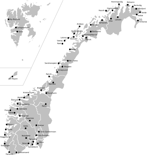
| Description | Map of Norway with all current and former public and military airports. This excludes private airports without scheduled services. Note: Svalbard and Jan Mayen are not to scale, and not geographically correctly located in relation to each other and mainland Norway. The accuracy of the map makes accurate placement of the airports sometimes a little off. |
| Date | (UTC) |
| Source | |
| Auteur |
|
Ce fichier est disponible selon les termes de la licence Creative Commons Attribution – Partage dans les Mêmes Conditions 3.0 (non transposée).
- Vous êtes libre :
- de partager – de copier, distribuer et transmettre cette œuvre
- d’adapter – de modifier cette œuvre
- Sous les conditions suivantes :
- paternité – Vous devez donner les informations appropriées concernant l'auteur, fournir un lien vers la licence et indiquer si des modifications ont été faites. Vous pouvez faire cela par tout moyen raisonnable, mais en aucune façon suggérant que l’auteur vous soutient ou approuve l’utilisation que vous en faites.
- partage à l’identique – Si vous modifiez, transformez, ou vous basez sur cette œuvre, vous devez distribuer votre contribution sous la même licence ou une licence compatible avec celle de l’original.
Journal des téléversements d’origine
This image is a derivative work of the following images:
- File:Norway_counties_blank.svg licensed with Cc-by-sa-2.5
- 2008-07-16T09:52:07Z ZorroIII 256x256 (84546 Bytes) Correct county code for Telemark
- 2007-09-21T21:39:11Z Marmelad 256x256 (84546 Bytes) added information about regions
- 2007-09-21T21:24:01Z Marmelad 256x256 (84348 Bytes) forgot to remove example colouring
- 2007-09-21T21:23:01Z Marmelad 256x256 (84340 Bytes) {{Information |Description=Blank map of Norwegian counties, used e.g. to create locator maps. |Source=Based on [[:Image:Norway counties.svg]] |Date=2007-09-21 |Author=[[User:Marmelad|Marmelad]] |Permission= {{cc-by-sa-2.5}}
- File:Svalbard_outline.svg licensed with PD-self
- 2009-04-28T10:05:31Z Arsenikk 200x265 (39847 Bytes) {{Information |Description={{en|1=Vector outline map of Svalbard, Norway.}} |Source=Own work by uploader |Author=[[User:Arsenikk|Arsenikk]] |Date=2009-04-29 |Permission= |other_versions= }} [[Category:Maps of Svalbard]] [[C
- File:Jan_Mayen_outline.svg licensed with PD-self
- 2009-09-12T10:29:46Z Arsenikk 294x267 (8401 Bytes) {{Information |Description=Blank map of Jan Mayen (Norway) |Source=*[[:File:Jan_Mayen_blank.jpg|]] |Date=2009-09-12 10:28 (UTC) |Author=*[[:File:Jan_Mayen_blank.jpg|]]: Alfanje *derivative work: ~~~ |Permission=see below |oth
Téléversé avec derivativeFX
Historique du fichier
Cliquer sur une date et heure pour voir le fichier tel qu'il était à ce moment-là.
| Date et heure | Vignette | Dimensions | Utilisateur | Commentaire | |
|---|---|---|---|---|---|
| actuel | 2 mai 2021 à 13:23 | | 501 × 526 (166 kio) | BIL | I moved some airports slightly to reflect their actual position |
| 12 septembre 2009 à 14:15 |  | 501 × 526 (170 kio) | Arsenikk | {{Information |Description=Map of Norway with all current and former public and military airports. This excludes private airports without scheduled services. Note: Svalbard and Jan Mayen are not to scale, and not geographically correctly located in relati |
Utilisation du fichier
La page suivante utilise ce fichier :
Usage global du fichier
Les autres wikis suivants utilisent ce fichier :
- Utilisation sur en.wikipedia.org
- Utilisation sur fa.wikipedia.org
- Utilisation sur it.wikipedia.org
- Utilisation sur no.wikipedia.org
- Utilisation sur uk.wikipedia.org
- Utilisation sur zh.wikipedia.org