
Fichier:Adygea districts.png

Taille de cet aperçu : 785 × 600 pixels. Autres résolutions : 314 × 240 pixels | 628 × 480 pixels | 1 013 × 774 pixels.
Fichier d’origine (1 013 × 774 pixels, taille du fichier : 56 kio, type MIME : image/png)
Ce fichier et sa description proviennent de Wikimedia Commons.
Description
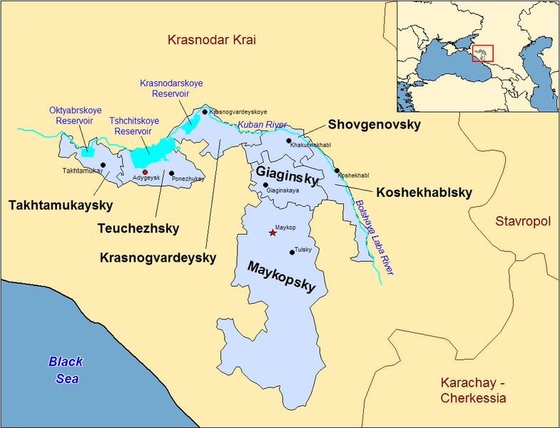
| Description | Map of the districts of the Adygea republic of Russia. Created by Rarelibra 13:10, 30 March 2007 (UTC) for public domain use, using MapInfo Professional v8.5 and various mapping resources. |
| Date | 30 mars 2007 (date de téléversement originale) |
| Source | La source n’a pas pu être reconnue automatiquement. « Travail personnel » supposé (étant donné la revendication de droit d’auteur). |
| Auteur | L’auteur n’a pas pu être identifié automatiquement. Il est supposé qu'il s'agit de : Rarelibra (étant donné la revendication de droit d’auteur). |
Previous summary and history (en.wikipedia)
Map of the districts of the Republic of Adygea (federal subject of Russia). Created by Rarelibra 20:52, 20 December 2006 (UTC) for public domain use, using MapInfo Professional v8.5 and various mapping resources. Special thanks to w:User:Ezhiki for both his patience and input to help complete this map for his wiki project.
- 16:06, April 3, 2007 . . Rarelibra (Talk | contribs | block) . . 1056×816 (58,397 bytes) (Updated version)
- 17:35, March 27, 2007 . . Rarelibra (Talk | contribs | block) . . 823×752 (50,852 bytes) (Updated map)
- 22:34, December 20, 2006 . . Rarelibra (Talk | contribs | block) . . 1281×878 (48,913 bytes) (Map of the districts of the Republic of Adygea (a federal subject of Russia). Created by ~~~~ for public domain use with attribution under GNU. Created using MapInfo Professional v8.5 and various mapping resources. Special thanks to User:Ezhiki for hi)
- 20:52, December 20, 2006 . . Rarelibra (Talk | contribs | block) . . 1281×878 (43,557 bytes) (Map of the districts of the Republic of Adygea (federal subject of Russia). Created by ~~~~ for public domain use, using MapInfo Professional v8.5 and various mapping resources. Special thanks to User:Ezhiki for both his patience and input to help com)
Conditions d’utilisation
| Moi, propriétaire des droits d’auteur sur cette œuvre, la place dans le domaine public. Ceci s'applique dans le monde entier. Dans certains pays, ceci peut ne pas être possible ; dans ce cas : J’accorde à toute personne le droit d’utiliser cette œuvre dans n’importe quel but, sans aucune condition, sauf celles requises par la loi. |
Historique du fichier
Cliquer sur une date et heure pour voir le fichier tel qu'il était à ce moment-là.
| Date et heure | Vignette | Dimensions | Utilisateur | Commentaire | |
|---|---|---|---|---|---|
| actuel | 1 janvier 2024 à 00:53 | | 1 013 × 774 (56 kio) | User-duck | Cropped border using CropTool with lossless mode. |
| 23 avril 2007 à 15:18 |  | 1 056 × 816 (57 kio) | Rarelibra | Reverted to earlier revision | |
| 21 avril 2007 à 17:54 |  | 1 056 × 816 (46 kio) | David Kernow~commonswiki | ||
| 3 avril 2007 à 18:04 |  | 1 056 × 816 (57 kio) | Rarelibra | Updated version | |
| 30 mars 2007 à 15:10 |  | 823 × 752 (50 kio) | Rarelibra | Map of the districts of the Adygea republic of Russia. Created by ~~~~ for public domain use, using MapInfo Professional v8.5 and various mapping resources. |
Utilisation du fichier
La page suivante utilise ce fichier :
Usage global du fichier
Les autres wikis suivants utilisent ce fichier :
- Utilisation sur af.wikipedia.org
- Utilisation sur azb.wikipedia.org
- Utilisation sur ca.wikipedia.org
- Utilisation sur cy.wikipedia.org
- Utilisation sur de.wikipedia.org
- Utilisation sur el.wikipedia.org
- Utilisation sur en.wikipedia.org
- Utilisation sur fa.wikipedia.org
- Utilisation sur fi.wikipedia.org
- Utilisation sur frr.wikipedia.org
- Utilisation sur incubator.wikimedia.org
- Utilisation sur io.wikipedia.org
- Utilisation sur it.wikipedia.org
- Utilisation sur krc.wikipedia.org
- Utilisation sur lv.wikipedia.org
- Utilisation sur mn.wikipedia.org
- Utilisation sur nl.wikipedia.org
- Utilisation sur pl.wikipedia.org
- Utilisation sur pl.wiktionary.org
- Utilisation sur pt.wikipedia.org
- Utilisation sur ru.wikivoyage.org