
Fichier:20110406 PIA13809 D2011 0404 D036 cropped-full.jpg
Fichier d’origine (1 290 × 1 571 pixels, taille du fichier : 853 kio, type MIME : image/jpeg)
Ce fichier et sa description proviennent de Wikimedia Commons.
Description
| Description |
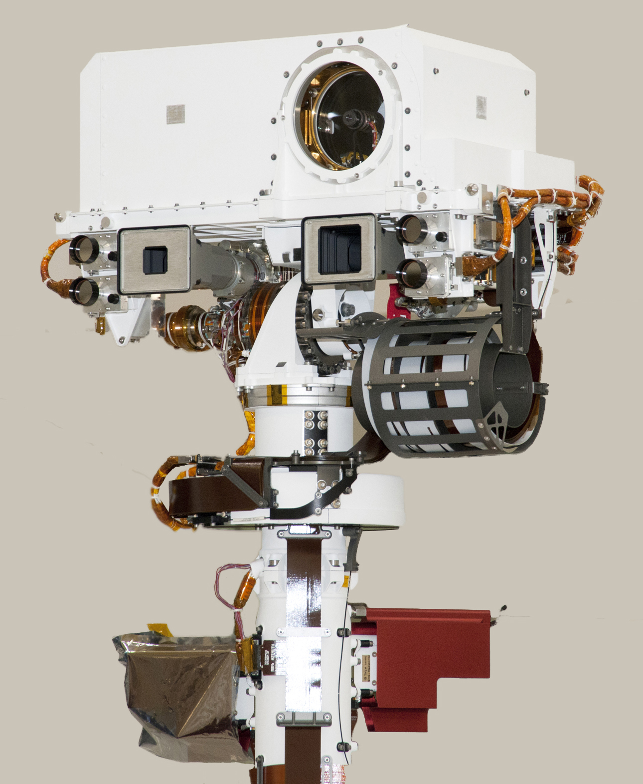
English: Top of Mars Rover Curiosity's Remote Sensing Mast
The remote sensing mast on NASA Mars rover Curiosity holds two science instruments for studying the rover's surroundings and two stereo navigation cameras for use in driving the rover and planning rover activities. This view of the top of the mast was taken April 4, 2011, inside the Spacecraft Assembly Facility at NASA's Jet Propulsion Laboratory, Pasadena, Calif. For scale, the width of the white box at the top is about 0.4 meter (16 inches). The circle in the white box is the laser and telescope of an instrument named Chemistry and Camera, or ChemCam. The instrument can pulse its laser at a rock up to about 7 meters (23 feet) away and determine the rock's composition by examining the resulting spark with the telescope and spectrometers. Just below that circle is the square opening for a wide-angle camera that is paired with a telephoto camera (the smaller square opening to the left) in the rover's Mast Camera, or Mastcam, which can take high-definition, full-color video with both "eyes." Each of the two Mastcam camera heads has a wheel of filters that can be used for studying geological targets at specific visible-light and infrared wavelengths. Farther outward from each of the Mastcam cameras are circular lens openings for the rover's stereo navigation camera and its backup twin. ChemCam was conceived, designed and built by a U.S.-French team led by Los Alamos National Laboratory in Los Alamos, N. M.; the Centre National d'Études Spatiales (the French government space agency); the Centre d'Étude Spatiale des Rayonnements at the Observatoire Midi-Pyrénées, Toulouse, France; and JPL. Malin Space Science Systems, San Diego, provided Mastcam. JPL, a division of the California Institute of Technology in Pasadena, manages the Mars Science Laboratory mission for the NASA Science Mission Directorate, Washington. This mission will land Curiosity on Mars in August 2012. Researchers will use the tools on the rover to study whether the landing region has had environmental conditions favorable for supporting microbial life and favorable for preserving clues about whether life existed.Polski: Najwyższy element należącego do NASA łazika Curiosity - zdalnie sterowany maszt. Zdalnie sterowany maszt łazika Curiosity podtrzymuje dwa naukowe instrumenty (w formie kamer), w celu studiowania otoczenia łazika, oraz dwie kamery stereo nawigacyjne, użyteczne w kierowaniu łazikiem, a także w planowaniu jego przyszłego wykorzystania. Zdjęcie masztu wykonano 4 kwietnia 2011r. wewnątrz hali montażu statku kosmicznego w Jet Propulsion Laboratory w Pasadenie w Kaliforni. Szerokość białej skrzynki na szczycie masztu wynosi około 0.4 metra. Koło w białej skrzynce jest otworem wyjściowym lasera i lunety, nazywanych Chemia i Kamera ang. ChemCam. Urządzenie wysyła serie impulsów laserowych do skał marsjańskich oddalonych maksymalnie do 7 metrów i określa skład chemiczny badanych skał przy użyciu lunety i spektroskopu, poprzez analizę wytworzonej kropelki plazmy. Poniżej owalnego okienka znajduje się okienko kwadratowe dla szerokokątnej kamery sparowanej z kamerą wyposażoną w teleobiektyw (mniejsze kwadratowe okienko z lewej strony). Obydwie kamery tworzą kolorowe, o wysokiej rozdielczości, stereoskopowe oczy łazika Curiosity. Każda ze stereoskopowych głowic kamer masztowych posiada tarczę z filtrami, które mogą być używane do studiowania geologicznych obiektów w specyficznym zakresie długości fal światła widzialnego, lub w podczerwieni. Dalej na zewnątrz kamer masztowych znajdują się okrągłe otwory przez które patrzą stereoskopowe, nawigacyjne obiektywy i ich zapasowi bliźniacy. Naukowcy będą używać narzędzi zgromadzonych na Curiosity do oceny czy wybrany region lądowania jest korzystny do wspierania mikrobiologicznego życia i czy jest przychylny do zachowania ewentualnych wskazówek o tym, że życie tam kiedyś istniało. |
| Date | |
| Source | http://marsprogram.jpl.nasa.gov/msl/multimedia/images/?ImageID=3487 |
| Auteur | NASA |
Conditions d’utilisation
| Ce fichier provient de la NASA. Sauf exception, les documents créés par la NASA ne sont pas soumis à copyright. Pour plus d'informations, voir la politique de copyright de la NASA. | ||
 |
Attention :
|
Historique du fichier
Cliquer sur une date et heure pour voir le fichier tel qu'il était à ce moment-là.
| Date et heure | Vignette | Dimensions | Utilisateur | Commentaire | |
|---|---|---|---|---|---|
| actuel | 16 mars 2013 à 22:23 | | 1 290 × 1 571 (853 kio) | Whaledad | Cropped and background removed |
| 24 juin 2011 à 00:12 |  | 2 500 × 1 693 (2,27 Mio) | Pline |
Utilisation du fichier
La page suivante utilise ce fichier :
Usage global du fichier
Les autres wikis suivants utilisent ce fichier :
- Utilisation sur bn.wikipedia.org
- Utilisation sur ca.wikipedia.org
- Utilisation sur de.wikipedia.org
- Utilisation sur en.wikipedia.org
- Utilisation sur es.wikipedia.org
- Utilisation sur fa.wikipedia.org
- Utilisation sur ja.wikipedia.org
- Utilisation sur kk.wikipedia.org
- Utilisation sur ko.wikipedia.org
- Utilisation sur pl.wikipedia.org
- Utilisation sur ru.wikipedia.org
- Utilisation sur sr.wikipedia.org
- Utilisation sur test.wikipedia.org
- Utilisation sur uk.wikipedia.org
- Utilisation sur zh.wikipedia.org