
Fichier:2010 Haiti earthquake USAID intensity map 2.svg

Taille de cet aperçu PNG pour ce fichier SVG : 744 × 533 pixels. Autres résolutions : 320 × 229 pixels | 640 × 458 pixels | 1 024 × 734 pixels | 1 280 × 917 pixels | 2 560 × 1 834 pixels.
Fichier d’origine (Fichier SVG, nominalement de 744 × 533 pixels, taille : 1,52 Mio)
Ce fichier et sa description proviennent de Wikimedia Commons.
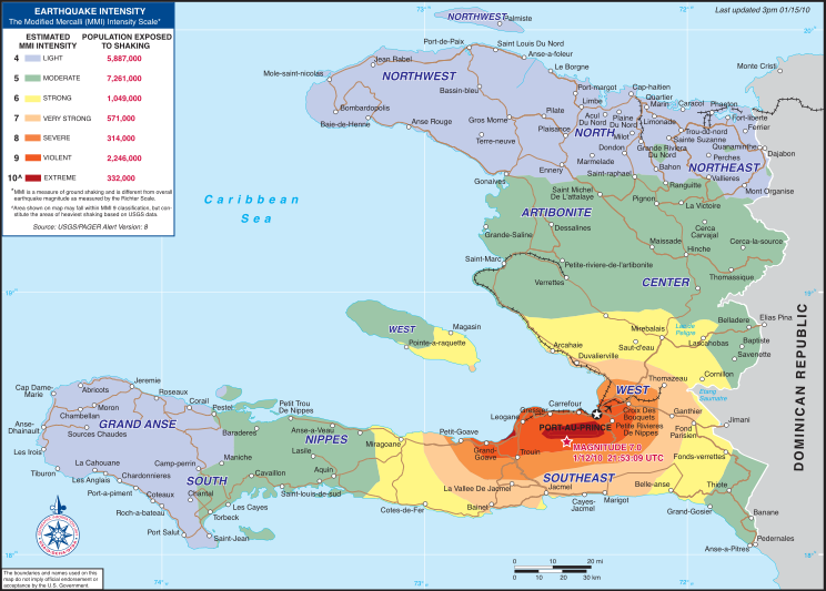
| Description | Intensity map for the 2010 Haiti earthquake | |||
| Date | ||||
| Source | USAID Haiti earthquake page (direct PDF URL [1]) | |||
| Auteur | USAID | |||
| Autorisation (Réutilisation de ce fichier) |
|

Historique du fichier
Cliquer sur une date et heure pour voir le fichier tel qu'il était à ce moment-là.
| Date et heure | Vignette | Dimensions | Utilisateur | Commentaire | |
|---|---|---|---|---|---|
| actuel | 16 janvier 2010 à 11:37 | | 744 × 533 (1,52 Mio) | Clindberg | {{Information |Description=Intensity map for the 2010 Haiti earthquake |Source=[http://www.usaid.gov/locations/latin_america_caribbean/country/haiti/eq/ USAID Haiti earthquake page] (direct PDF URL [http://www.usaid.gov/locatio |
Utilisation du fichier
Les 4 pages suivantes utilisent ce fichier :
Usage global du fichier
Les autres wikis suivants utilisent ce fichier :
- Utilisation sur ar.wikipedia.org
- Utilisation sur ast.wikipedia.org
- Utilisation sur es.wikipedia.org
- Utilisation sur gl.wikipedia.org
- Utilisation sur qu.wikipedia.org
- Utilisation sur ro.wikipedia.org
- Utilisation sur sl.wikipedia.org
- Utilisation sur sr.wikipedia.org