
Fichier:1951 CIA map of Syria – principal Arab and Kurdish tribes, 1951.jpg

Taille de cet aperçu : 737 × 600 pixels. Autres résolutions : 295 × 240 pixels | 590 × 480 pixels | 944 × 768 pixels | 1 258 × 1 024 pixels | 2 516 × 2 048 pixels | 5 868 × 4 776 pixels.
Fichier d’origine (5 868 × 4 776 pixels, taille du fichier : 2,5 Mio, type MIME : image/jpeg)
Ce fichier et sa description proviennent de Wikimedia Commons.
Description
| Description |
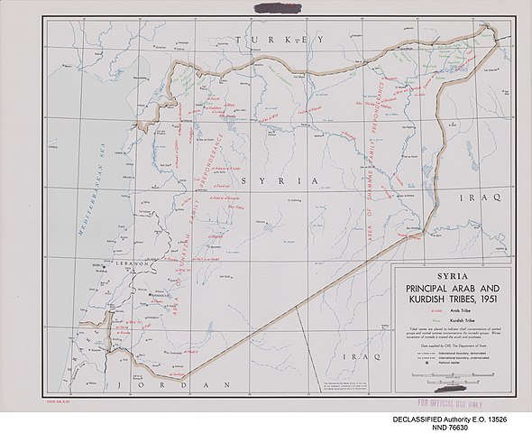
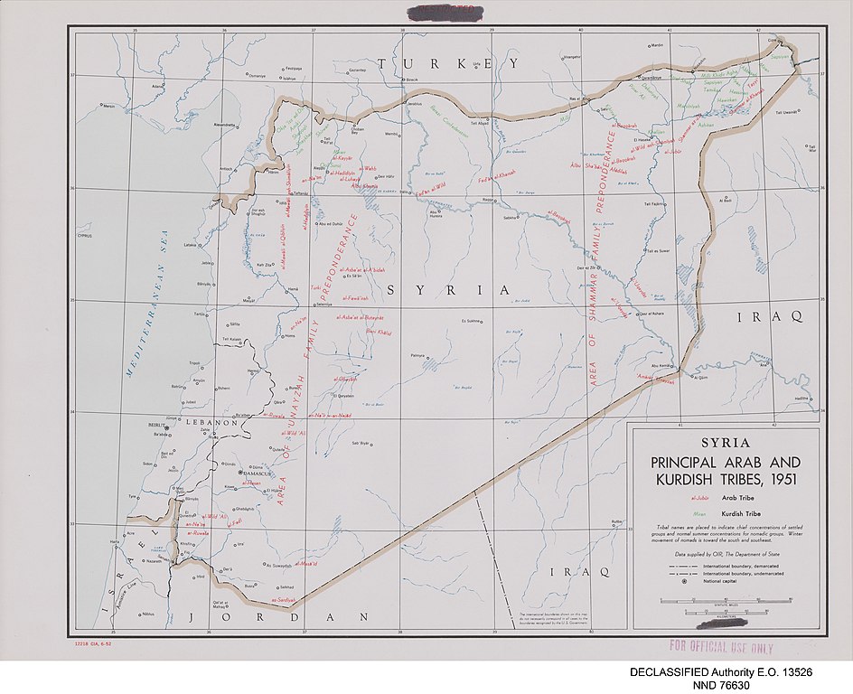
English: Map of Syria prepared by the United States Central Intelligence Agency's Map Branch in 1951. Names of Arab tribes are written in red; names of Kurdish tribes are in green. Marked in red at bottom left: "12218 CIA, 6-52", and top centre: "RESTRICTED" and "SECURITY INFORMATION" (struck through). Stamped "FOR OFFICIAL USE ONLY" in red, bottom right. In the map area itself, the word "RESTRICTED" in red has been deleted from the legend at the bottom right. In the bottom centre is printed: "The international boundaries shown on this map do not necessarily correspond in all cases to the boundaries recognized by the U.S. Government." Digitally added to the image, beneath the map: "DECLASSIFIED Authority E.O. 13526" and "NND 76630". |
| Date | |
| Source |
United States National Archives Published Maps, 1947–2015 Record Group 263: Records of the Central Intelligence Agency, 1894–2002 https://catalog.archives.gov/id/175515101 (National Archives Identifier: 175515101) |
| Auteur | Map Service Center, Central Intelligence Agency, United States National Security Council |
| Autres versions |
.jpg)
.jpg)
.jpg)
.jpg)
.jpg)
Conditions d’utilisation
| Cette image est une œuvre d'un employé de la Central Intelligence Agency, réalisée dans le cadre des tâches officielles de cette personne. En tant qu’œuvre du Gouvernement des États-Unis d'Amérique, ce document est placé dans le domaine public aux États-Unis d'Amérique.
|

|
Historique du fichier
Cliquer sur une date et heure pour voir le fichier tel qu'il était à ce moment-là.
| Date et heure | Vignette | Dimensions | Utilisateur | Commentaire | |
|---|---|---|---|---|---|
| actuel | 24 mai 2021 à 06:32 | | 5 868 × 4 776 (2,5 Mio) | GPinkerton | Uploaded a work by Map Service Center, Central Intelligence Agency, United States National Security Council from United States National Archives Published Maps, 1947–2015 Record Group 263: Records of the Central Intelligence Agency, 1894–2002 https://catalog.archives.gov/id/175515101 (National Archives Identifier: 175515101) with UploadWizard |
Utilisation du fichier
Aucune page n’utilise ce fichier.