
Fichier:1784 Bocage Map of the City of Athens in Ancient Greece - Geographicus - AthensPlan2-white-1793.jpg
Taille de cet aperçu : 739 × 599 pixels. Autres résolutions : 296 × 240 pixels | 592 × 480 pixels | 947 × 768 pixels | 1 263 × 1 024 pixels | 2 515 × 2 040 pixels.
Fichier d’origine (2 515 × 2 040 pixels, taille du fichier : 1,06 Mio, type MIME : image/jpeg)
Ce fichier et sa description proviennent de Wikimedia Commons.
| Jean-Denis Barbié du Bocage : Athens
( |
||||||||||||||||||||||||
|---|---|---|---|---|---|---|---|---|---|---|---|---|---|---|---|---|---|---|---|---|---|---|---|---|
| Artiste |
|
|||||||||||||||||||||||
| Titre |
Athens |
|||||||||||||||||||||||
| Description |
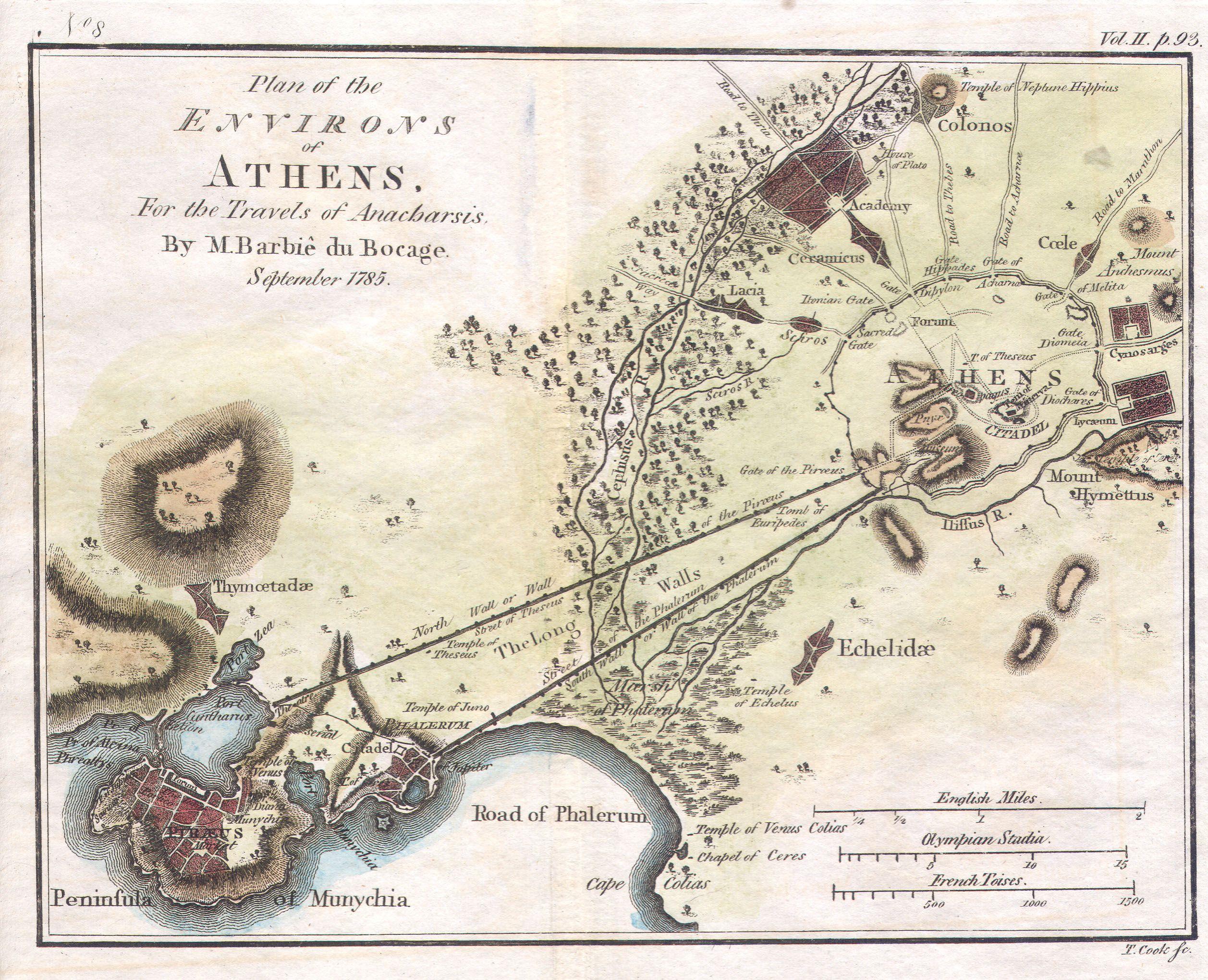
English: This lovely little map or city plan of Athens in Ancient Greece, was prepared by M. Barbie de Bocage in 1784 for the “Travels of Anarcharsis”. Athens, capital of the Athenian Empire, was the heart of Ancient Greek culture and the quintessential Ancient Greek city state. This plan of Athens, based on excavations and ancient sources offers impressive and accurate detail. |
|||||||||||||||||||||||
| Date | 1784 | |||||||||||||||||||||||
| Dimensions | hauteur : 9 pouces (22,8 cm) ; largeur : 13 pouces (33 cm) | |||||||||||||||||||||||
| Numéro d’inventaire |
liens Geographicus : AthensPlan2-white-1793 |
|||||||||||||||||||||||
| Source / photographe |
|
|||||||||||||||||||||||
| Autorisation (Réutilisation de ce fichier) |
|
|||||||||||||||||||||||

Historique du fichier
Cliquer sur une date et heure pour voir le fichier tel qu'il était à ce moment-là.
| Date et heure | Vignette | Dimensions | Utilisateur | Commentaire | |
|---|---|---|---|---|---|
| actuel | 12 mars 2011 à 14:21 | | 2 515 × 2 040 (1,06 Mio) | BotMultichill | {{subst:User:Multichill/Geographicus |link=http://www.geographicus.com/P/AntiqueMap/AthensPlan2-white-1793 |product_name=1784 Bocage Map of the City of Athens in Ancient Greece |map_title=Athens |description=This lovely little map or city plan of Athens i |
Utilisation du fichier
La page suivante utilise ce fichier :
Usage global du fichier
Les autres wikis suivants utilisent ce fichier :
- Utilisation sur ca.wikipedia.org
- Utilisation sur el.wikipedia.org
- Utilisation sur et.wikipedia.org
- Utilisation sur fi.wikipedia.org
- Utilisation sur it.wikipedia.org
- Utilisation sur ru.wikipedia.org
- Utilisation sur www.wikidata.org